Atlantic hurricane season ends, reaching ‘hyperactive’ level despite missing forecast targets
The "hyperactive" designation comes from the season’s tally of Accumulated Cyclone Energy – a measurement that accounts for the strength and amount of time tropical storms and/or hurricanes are active in the basin.
Hurricane season reaches 'hyperactive' criteria even if it quite reach lofty forecasts
There were 18 named storms this year and 11 hurricanes -- both well above average.
FORT COLLINS, Colo. – As the 2024 Atlantic hurricane season ends Saturday, it will indeed go down in the books as a "hyperactive" season that, despite not quite reaching the lofty forecasts for record-breaking activity given in the spring, still reached well-above-average levels, according to researchers at Colorado State University (CSU).
The "hyperactive" designation comes from the season’s tally of Accumulated Cyclone Energy (ACE) – a measurement that accounts for the strength and amount of time tropical storms and/or hurricanes are active in the basin.
The 2024 season finished with an ACE value of 162 – above the "hyperactive" threshold of 159.6 and 23% above average, but still short of the initial CSU forecast of 210, which was increased to 230 later in the season.
HURRICANES HELENE AND MILTON, LIKE DOZENS OF OTHERS, ENERGIZED BY CLIMATE CHANGE, REPORT SAYS
CSU forecasters also predicted 23 named storms this season with a brief forecast increase to 25 named storms in their July 9 update. The season instead netted 18 named storms, which was short of the forecast but still above the average of 14-15.
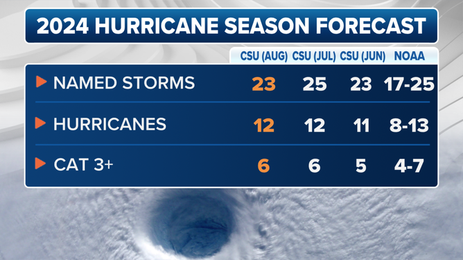
This graphic shows the updated 2024 Atlantic hurricane season forecast as of Aug. 6, 2024.
(CSU / FOX Weather)
"Our April and June seasonal forecasts performed best for all metrics," wrote Dr. Phil Klotzbach and his team at CSU. "The slight increase in overall activity that we predicted with our July and August updates did not verify. We characterize our forecasts for 2024 as a modest over-forecast of overall activity."
CSU did predict 11-12 hurricanes this season, matching the 11 observed.
Unexpected midseason lull weighed on seasonal forecast accuracy
Multiple factors in play led to the aggressive forecast. Water temperatures in the Atlantic, Caribbean and Gulf of Mexico were at or near record warmth. Wind shear was weak, dropping to the lowest levels on record between August and October, CSU said.
The front and back edges of the season were very active, with Hurricane Beryl setting records for the earliest Category 5 storm on record, and 10 named storms between Sept. 9 and Oct. 31 – with three more in November. Leslie, Milton and Kirk became the first time a trio of hurricanes were active in the Atlantic Basin after September, according to NOAA. Seven hurricanes forming since Sept. 25 was also a record.
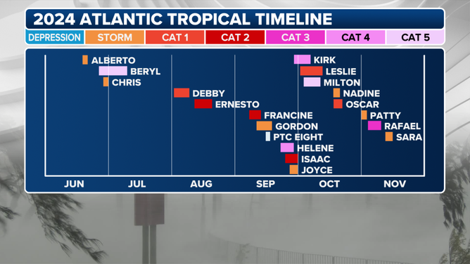
Hurricane season 2024 summary.
(FOX Weather)
2004: A HURRICANE SEASON THAT FLORIDA NEVER WANTS TO REPEAT
But an unexpected weeks-long lull came from late August into late September, which is usually among the most active periods of the season. Klotzbach and his team attributed the lull to a combination of factors. Among them include a northward shift in storm tracks coming off Africa that put systems in drier air, an anomalously warm upper atmosphere, and too much wind shear in the heart of the Atlantic. The gap in newly named storms from Aug. 13 to Sept. 8 was the first time since 1968.
The lull led to the season totals coming in less than forecast. But even with the fewer number of storms, it was still a powerful season.
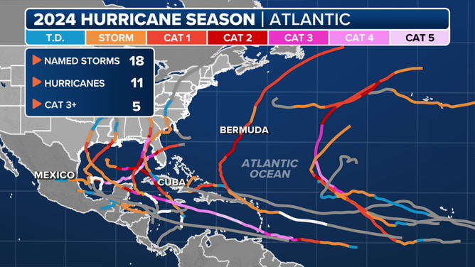
2024 Hurricane Season
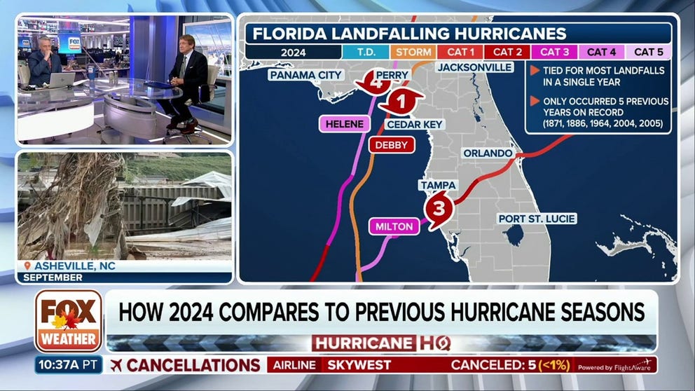
Five hurricanes reached the U.S. shores, including Beryl, Debby, Francine, Helene and Milton.
Just the last two made landfall in Florida within two weeks and caused widespread devastation across the state and into the Southeast, killing over 250 people and causing an estimated $200 billion in damage.
Still plenty of unprecedented tropical activity
Despite the number of tropical cyclones coming up short of seasonal forecasts, CSU says there were a number of events and observations that put this season well above a typical hurricane season:
- The 11 hurricanes in the Atlantic Basin tied for fifth place for most hurricanes in a season.
- Five hurricanes reaching U.S. shores tied with 1893, 2004 and 2005 for second-most U.S. landfalls in a season, behind the six in 1886, 1985 and 2020.
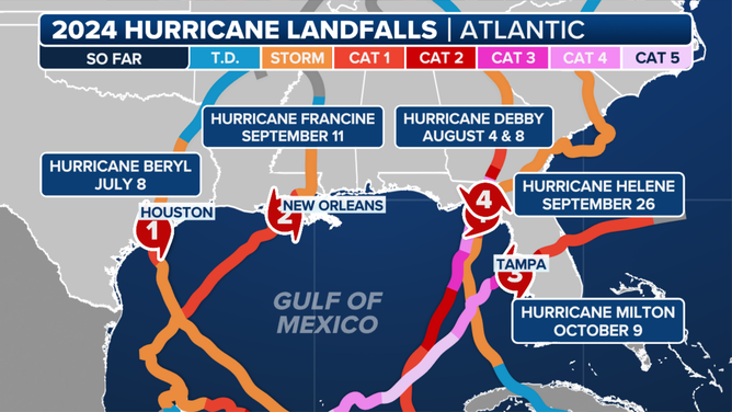
2024 Atlantic Landfalls
(FOX Weather)
- Four major hurricanes formed in the Atlantic since Sept. 26 – the second most in that period behind the five that formed in 2020.
- The ACE value of 162 in 2024 is the 11th "hyperactive" season since the satellite era began in 1966. The 100 ACE produced since Sept. 24 was the second most generated from that time forward, just behind 1878's ACE of 109.
- Hurricanes Kirk and Leslie set records for the easternmost formation of a hurricane in October.
- Hurricane Beryl set records for the earliest Category 5 storm, the greatest rapid intensification before July (63 mph in 24 hours), and 165-mph peak wind speed was the strongest hurricane prior to August.
- Hurricane Milton's peak wind speed of 180 mph was the strongest in the Gulf of Mexico since Hurricane Rita in 2005, and its minimum central pressure of 897 mb was the lowest for a hurricane since Wilma in 2005.
- Hurricane Rafael was only the second time a major hurricane has formed in the Gulf of Mexico in November, aside from Kate in 1985.
