New National Hurricane Center map aims to highlight deadly rip current risks
These hidden dangers form when waves break near the shoreline, pile up water and form a narrow stream that flows quickly away from shore. Experts say it is that extra pull that can panic swimmers, which can lead to fatigue and eventually drowning.
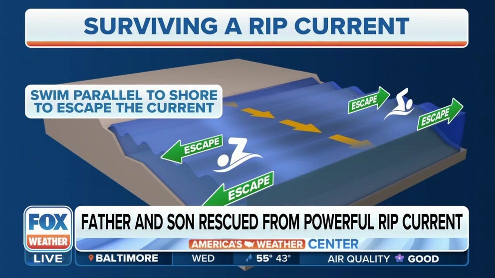
Staying safe around rip currents during beach season
American Lifeguard Association spokesperson Wyatt Werneth provides the best rip current safety tips after a father and son were rescued in Florida.
New during the 2025 tropical cyclone season, the National Hurricane Center will release maps highlighting where the greatest rip current risks exist when tropical weather events approach the U.S. coastline.
This new initiative aims to bring more visibility to a hidden hazard that annually kills more people in coastal areas than any other weather-related event.
According to the NHC, the rip current risk maps will not rely on new data or forecasts but will instead pull information already produced by local National Weather Service offices.
Local weather offices have long issued rip current statements, but the information is often difficult to find - leaving the public unaware of the dangers posed by the ocean.
The goal of the new NHC maps is to centralize and simplify these alerts, making it easier for the public to understand the risks associated with tropical systems, even those located hundreds of miles offshore.
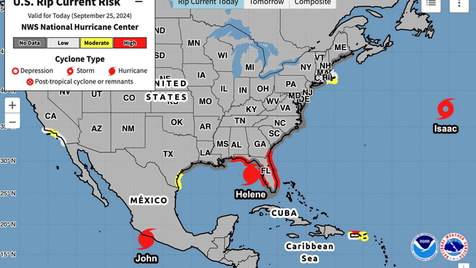
A prototype of the U.S. rip risk map from the National Hurricane Center.
(NOAA)
2025 ATLANTIC HURRICANE SEASON GUIDE: HERE’S WHAT TO KNOW ABOUT THE TROPICS THIS YEAR
Forecasters say the maps will display rip current threats along the East and Gulf Coasts, as well as often-overlooked coastal communities such as in Puerto Rico, the U.S. Virgin Islands and parts of California.
For example, of the 18 tropical cyclones that formed during the 2024 hurricane season, at least half came close enough to stir up ocean motion, leading to potential rip current risks.
Under the new products, those events would have triggered the NHC to display rip current forecasts - potentially raising public awareness of the beach hazards.
One such case was Hurricane Ernesto, which caused at least three surf-related deaths along the U.S. East Coast despite passing more than 500 miles east of the Carolinas.
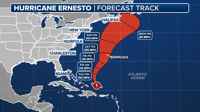
The forecast cone for Ernesto in 2024.
(FOX Weather)
Each year, rip currents claim around 100 lives in the United States, and according to the United States Lifesaving Association, rip currents are responsible for about 80% of all beach rescues.
These hidden dangers form when waves break near the shoreline, pile up water, and create a narrow stream that flows quickly away from the shore.
Experts say it’s the sudden outward pull that often causes swimmers to panic - leading to exhaustion and, in some cases, drowning.
IS THERE A WEATHER PHENOMENON KNOWN AS THE ATLANTIC NINA?
Most Rip Current Deaths Not Linked to Hurricanes
The NHC has not revealed what specifically prompted the development of the new map, especially since most rip current deaths are not associated with tropical cyclones.
Nevertheless, the move reflects a broader trend within the agency to improve public communication through enhanced forecasting products.
Just last year, the NHC began releasing inland watch and warning maps to better inform people living away from the coast about tropical threats.
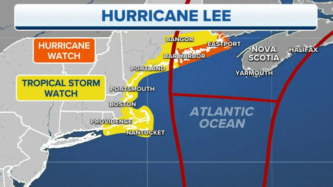
Hurricane Lee forecast cone
(FOX Weather)
Forecasters hope that changing public perception of the various risks posed by tropical cyclones, including rip currents, could ultimately save lives.
It’s worth noting that rip current advisories and forecasts are not new products.
FOX Weather found that some of the earliest rip current statements were issued along Florida’s east coast in the 1990s.
Since then, the number of participating NWS offices has grown significantly, now covering thousands of miles of coastline, including the Great Lakes.
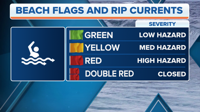
This graphic provides information on beach flags and rip currents.
(FOX Weather)