Winter storm blasts Pacific Northwest leading to chaos on multiple highways around Portland
Ice Storm Warnings cover more than 1 million people in the central and southern Willamette Valley, including Eugene and Salem, for as much as 0.2-0.3 inches of ice accretion. Freezing rain will likely be falling by the Thursday morning commute, making glazed roads a danger. Power outages from ice-coated trees and power lines could follow.

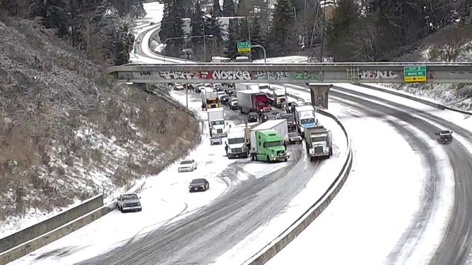
20-30 car pileup reported east of Portland, Oregon on Interstate 84
Winter weather conditions led to a 20-30 car pileup near Portland Thursday. The interstate is expected to be closed for some time as first responders work to clear the crash in the conditions.
Fast Facts:
- Dangerous freezing rain event triggered Ice Storm Warnings for more than 1 million people across much of Oregon's Willamette Valley.
- A 20- to 30-car pileup shut down a stretch of Interstate 84 in Multnomah County, east of Portland.
- Crashes also occurred along the southern border of Washington and the western border of Idaho.
PORTLAND, Ore. – A potent winter storm that is part of a 1,500-mile system which has pummeled the West Coast brought snow and freezing rain across a swath of the Pacific Northwest, including the Portland, Oregon, area.
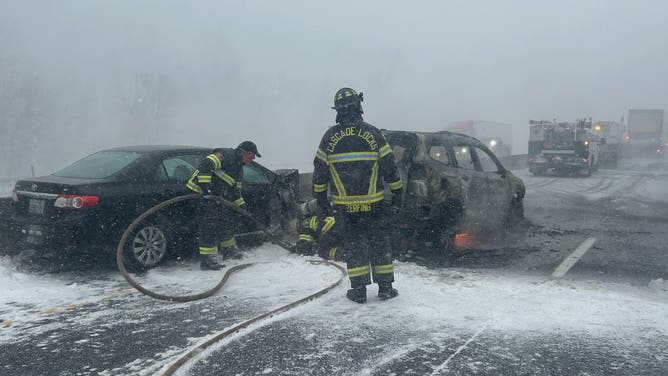
A significant crash involving 20-30 vehicles occurred in the westbound lanes of Interstate 84 just east of Portland on Thursday morning in what deputies described as whiteout conditions, according to the Multnomah County Sheriff's Office.
(Multnomah County Sheriff's Office / FOX Weather)
The agency originally reported more than 100 vehicles were involved in the crash. They later corrected the tally to 20-30 vehicles, saying whiteout conditions made the initial count difficult to distinguish which vehicles were involved in a collision or just stuck in the backup.
The crash was one of eight Oregon State Troopers responded to on I-84 on Thursday. Officials noted that four people were sent to the hospital for minor injuries.
I-84 reopened in that area Friday, but Oregon's Department of Transportation is still encouraging people to stay off the roads. This is as local law enforcement has responded to an unknown number of crashes elsewhere in Multnomah County.
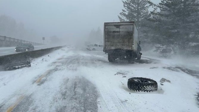
Accident at Hood River on I-84.
(Oregon DOT / FOX Weather)
Elsewhere in Oregon's most populous county, a snow-covered road led to multiple crashes involving more than 20 vehicles, according to the county sheriff’s office.
Hazardous road conditions spread to Washington and Idaho
Across the border in Washington, the weather was no better.
Multiple semis and vehicles collided in the snow-covered southbound lanes of Interstate 5 in Castle Rock, about 60 miles north of Portland, blocking the main artery connecting Seattle and Portland.
CALIFORNIA ATMOSPHERIC RIVER’S RELENTLESS RAINS TURN BURN SCARS INTO ROARING TORRENTS OF MUD
![Crash in Southwestern Washington]() Image 1 of 3
Image 1 of 3A multi-vehicle crash in the southbound lanes of I-5 in Castle Rock, Wash. (WSDOT)
![Crash in Southwestern Washington]() Image 2 of 3
Image 2 of 3A multi-vehicle crash in the southbound lanes of I-5 in Castle Rock, Wash. (WSDOT)
![Crash in Southwestern Washington]() Image 3 of 3
Image 3 of 3A multi-vehicle crash in the southbound lanes of I-5 in Castle Rock, Wash. (WSDOT)

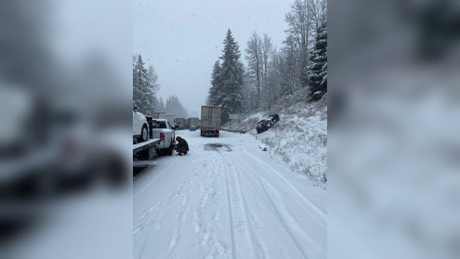

"We're seeing about 10 miles of backups, so avoid the area!" Washington State Department of Transportation officials warned early Thursday afternoon.
Officials in Clark County, home to Vancouver, Washington, also reported multiple crashes, as the snow was causing low visibility and slick roads, according to WSDOT.
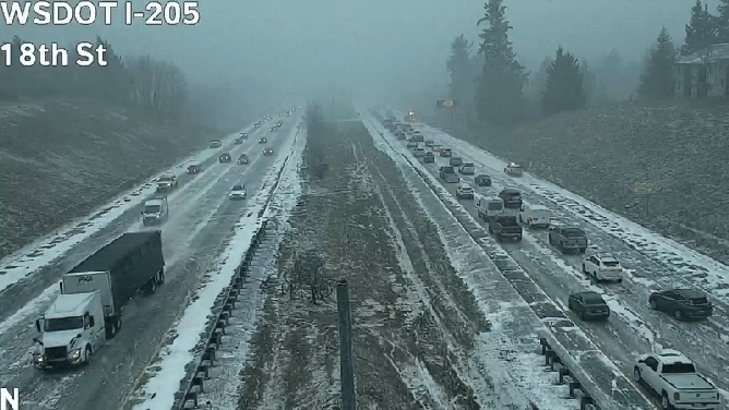
Slowdown on I-205 in southwest Washington.
(WSDOT Southwest / X / FOX Weather)
WSDOT officials noted that snowfall has caused multiple collisions and vehicles sliding on State Route 14, Interstate 205 and I-5.
Spinouts along I-5 in Vancouver, WA
(WSDOT / FOX Weather)
Issues on I-84 extended to Idaho near the Oregon border. Idaho State Police said at least two crashes were reported on that part of the interstate on Thursday. Much like the crashes farther west in Oregon's Multnomah County, the crashes were due to whiteout conditions.
Freezing rain concerns remain
Power outages from ice-coated trees and power lines have begun to occur. Nearly 8,500 customers in Washington are without power as of Thursday afternoon, according to FindEnergy.com. In Oregon, almost 1,900 customers were without power at the height of the storm. Most outages have since been restored.

(FOX Weather)
This event is the result of an area of low pressure swirling off the Pacific coast that is connected to an atmospheric river storm that brought torrential rains to California on Thursday.
The storm is carrying relatively mild air, but cold air is deeply entrenched in western Oregon, which has been in a week-long arctic chill.
As the warm rain pushes in over the freezing surface, it’s a classic recipe for freezing rain – and a lot of it.
Ice Storm Warnings cover more than one million people in the central and southern Willamette Valley, including Eugene and Salem in Oregon, for as much as 0.2-0.4 inches of ice accretion.

(FOX Weather)
Snow accumulations around Portland are expected to top out around 1-3 inches before the change to freezing rain, which is forecast to accrete to 0.1-0.2 inches. A Winter Storm Warning is in effect there through late Friday morning.
HOW MUCH ICE IS NEEDED TO KNOCK OUT POWER, DAMAGE TREES?

(FOX Weather)
In addition, strong easterly winds could reach 45- to 60-mph gusts in the eastern Portland suburbs along the cold outflow of the Columbia River Gorge, extending freezing rain threats and dropping wind chills into the teens.
WHAT IS THE DIFFERENCE BETWEEN SNOW, SLEET, AND FREEZING RAIN
What comes after the storm
The freezing rain threat lasts into about midday Friday before the storm pushes off to the east and the region temporarily dries out. Light snow up to about an inch could reach as far north as the southern Puget Sound region south of Seattle before drier air works its way there too.
However, another storm heading into the Northwest for the weekend may present a renewed ice threat in the eastern Portland area near the Columbia Gorge outflow until much milder air sweeps into the Northwest and ends any lowland wintry weather threat.