Invest 91L could develop into tropical depression or tropical storm as early as Thursday afternoon, NHC says
According to the National Hurricane Center, Invest 91L in the northeastern Gulf of Mexico has a high chance of development, with the odds currently placed at 70% over the next two days.
Tropical Depression or Storm may form in the Gulf of Mexico, NHC says
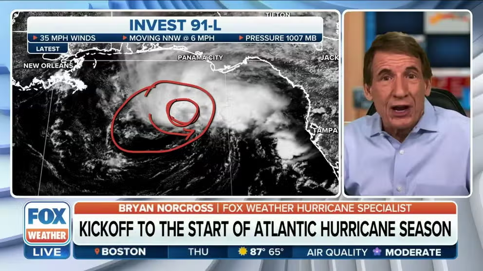
The National Hurricane Center has increased their risk of formation for the area of thunderstorms in the Gulf of Mexico. FOX Weather's Bryan Norcross has the latest forecast.
4:30 P.M. UPDATE: Tropical Depression Two has formed in the Gulf of Mexico. Check here for the latest on Tropical Depression Two.
Invest 91L, which is currently spinning in the Gulf of Mexico off the coast of Florida, has a high chance of developing into a tropical depression or tropical storm as early as Thursday afternoon, according to the latest update from the National Hurricane Center (NHC).
Recent satellite wind data, along with buoy and ship observations, has indicated the tropical disturbance has a broad but well-defined circulation with maximum sustained winds of 35 mph, the NHC said.
In addition, the NHC said shower and thunderstorm activity associated with Invest 91L is also showing signs of organization.
"Environmental conditions remain marginally favorable for additional development, and if these trends continue, a short-lived Tropical Depression or storm is likely to form as soon as this afternoon," the NHC said.
If the system does develop into a tropical storm, it would be named Arlene.
The NHC has dubbed this disturbance Invest 91L. An invest is simply a designation used by the NHC to identify an area of weather that is being investigated for possible tropical development.
According to the NHC, Invest 91L in the northeastern Gulf of Mexico has a high chance of development, with the odds currently placed at 70% over the next two days.
HERE ARE THE NAMES THAT WILL BE USED DURING THE 2023 ATLANTIC HURRICANE SEASON

(FOX Weather)
The Hurricane Hunters said Wednesday they plan to begin flying into the storm on Thursday, with the first mission scheduled to depart at 1:45 p.m. EDT. A second mission is scheduled to take off at 6:15 a.m. EDT Friday.
Regardless of how this system develops, Florida will get plenty of rain and wind as a result. Upwards of 3 inches of rain is possible across parts of the Florida Peninsula by the weekend.
The 2023 Atlantic hurricane season officially began Thursday.
Where is Invest 91L going?

(FOX Weather)
Computer forecast models show the various tracks that Invest 91L could take in the days ahead.
However, the consensus is that through Tuesday morning, Invest 91L will likely spin off to the south and eventually to the southeast and brush the coast of Cuba before making a turn to the northeast between Cuba and South Florida.
That expected track, though, will likely be adjusted over the coming hours and days, so be sure to check back with FOX Weather for updates.
Tropical mischief in June is common in the Gulf of Mexico
The Gulf of Mexico, northwestern Caribbean Sea and western Atlantic are the climatologically favored regions for tropical development in early June.
The FOX Forecast Center said due to marginal atmospheric conditions, tropical cyclones usually never reach hurricane status and remain either a tropical depression or tropical storm during their lifecycle.
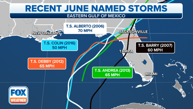
The last named storm to make landfall during June along Florida's west coast was Tropical Storm Colin in 2016.
The first named storm typically forms around June 20, according to NHC data.
WHY ATLANTIC HURRICANE SEASON RUNS FROM JUNE TO NOVEMBER

Recent June named storms
(FOX Weather)
How much rain will fall in Florida this week?
The highest rainfall amounts are expected to fall across portions of Central and South Florida from the Tampa and Orlando areas south through Melbourne, Fort Pierce, West Palm Beach and Miami.
Through the weekend, higher rain totals are expected across the southern half of the state. Most of Central and South Florida could see an inch or two, but many areas could see even higher totals.
Areas like West Palm Beach and Miami on the eastern side of the state could see 2 to 3 inches of rain through Sunday, with some spots seeing locally higher amounts.

(FOX Weather)
Florida faces flash flood threat
With the copious amounts of rain expected, the Sunshine State will be facing a flash flood threat through at least Sunday.
Flash flooding will be possible across much of the state on Thursday, including cities such as Cedar Key, Orlando, Tampa, Melbourne, Naples, West Palm Beach and Miami.
PEAK FLASH FLOOD SEASON IN US BEGINS IN JUNE

(FOX Weather)
Because of the heavy rain that’s expected, the NWS has issued a Flood Watch for several areas in South Florida that will remain in effect through at least Friday afternoon.
Those Flood Watches are in effect from Clewiston and West Palm Beach south through Fort Lauderdale, Miami and Homestead.

(FOX Weather)
Will the rain help drought conditions in Florida?
Recent rain in Florida has helped to reduce some of the drought conditions in the state, but most of the rain has been centered across southwestern areas, while areas on the Sunshine State's west coast are still extremely dry.
"I mean, look at Tampa, Sarasota, the St. Petersburg area," FOX Weather meteorologist Jason Frazer said, noting the extensive drought in the region. "You are on a Category 4 out of 5 (drought). And whenever we talk about a Category 4 out of 5 here, I mean, we’re talking about some of the worst here."
Frazer said Tampa needs about 2 to 3 inches of additional rain to ease a lot of the drought conditions in that area.
WHAT TO EXPECT IN THE TROPICS AS ATLANTIC HURRICANE SEASON BEGINS

(FOX Weather)
