

Hurricane Isaias could make landfall as a monster Cat 3 storm as conditions worsen along Gulf Coast
The National Hurricane Center said weather conditions are deteriorating quickly and urged Gulf Coast residents to seek shelter immediately.
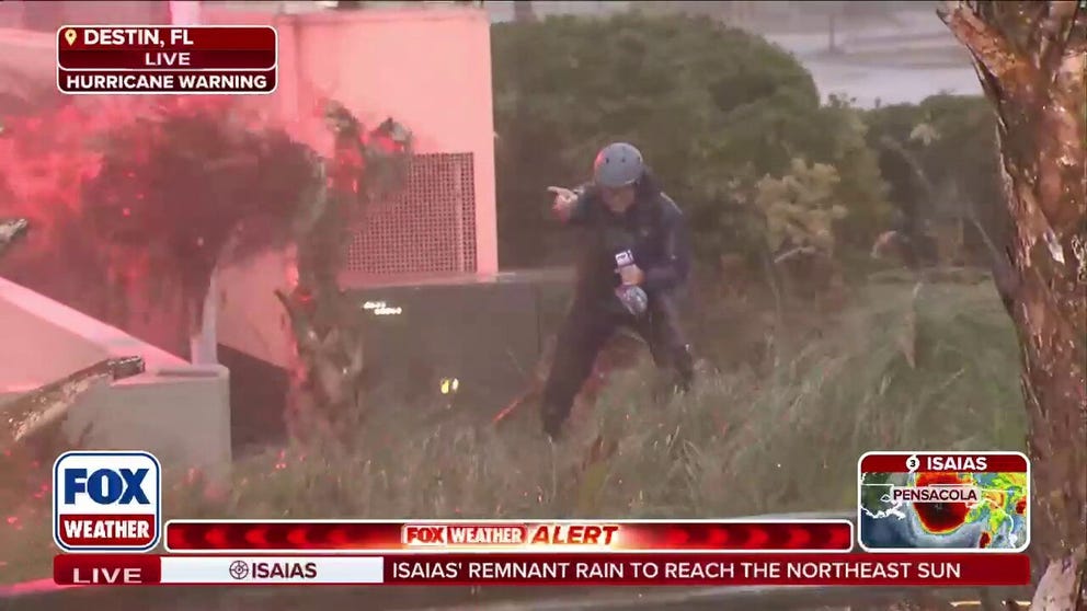
Robert Ray battles hurricane winds in Florida ahead of landfall
Hurricane Isaias is unleashing brutal conditions along Florida’s Gulf Coast, where FOX Weather Senior Correspondent Robert Ray is battling powerful winds and driving rain ahead of the Category 3 hurricane’s landfall.
Hurricane Isaias remains a monster Category 3 storm as it bears down on the northern Gulf Coast and could maintain major hurricane strength at landfall somewhere between Pensacola and Destin, Florida, late Friday.
More than 30 million people across Florida, Alabama, Mississippi, Louisiana and Georgia are expected to experience the worst of Isaias' impacts, while rain from the storm’s remnants will spread across more than 15 states in the eastern U.S. after landfall this weekend.
HURRICANE ISAIAS THREATENS MORE THAN COASTLINE WITH IMPACTS TO PUSH INLAND ACROSS SOUTH
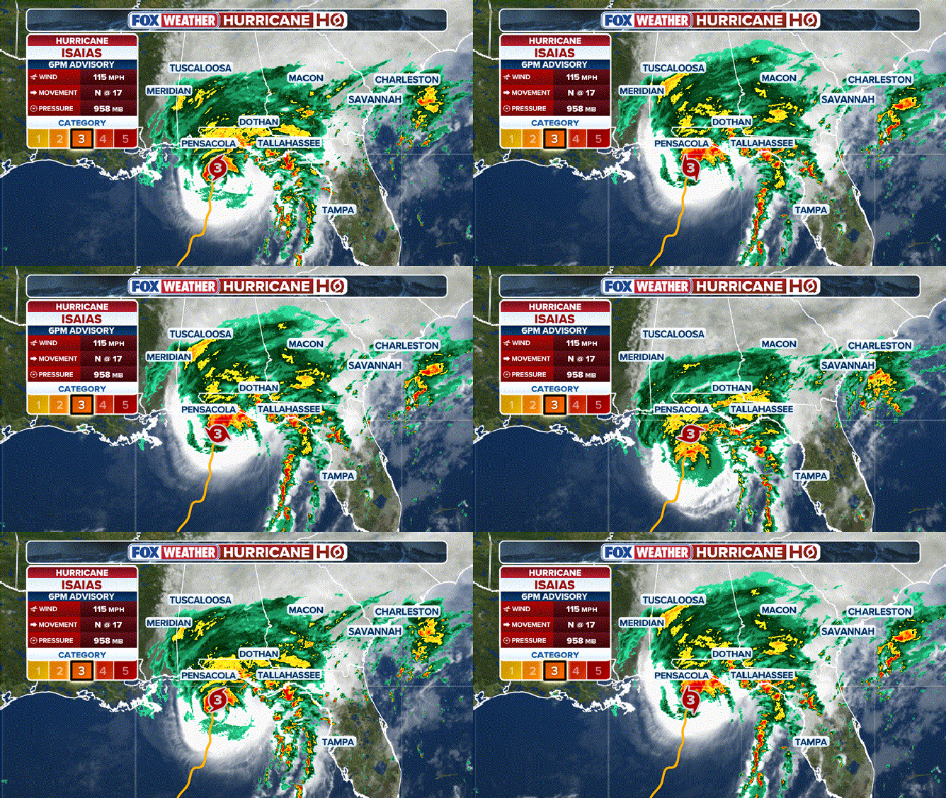
Hurricane Isaias as of 6 p.m. ET NHC update.
(FOX Weather)
Isaias is currently a Category 3 hurricane about 55 miles south of Pensacola, Florida, with sustained winds of 115 mph as it moves north at 18 mph.
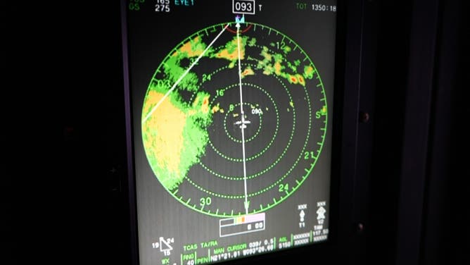
An investigation into the storm by NOAA and Air Force planes earlier on Friday found the hurricane's pressure had dropped, an obvious sign of ongoing atmospheric organization and possible intensification in the final hours before landfall.
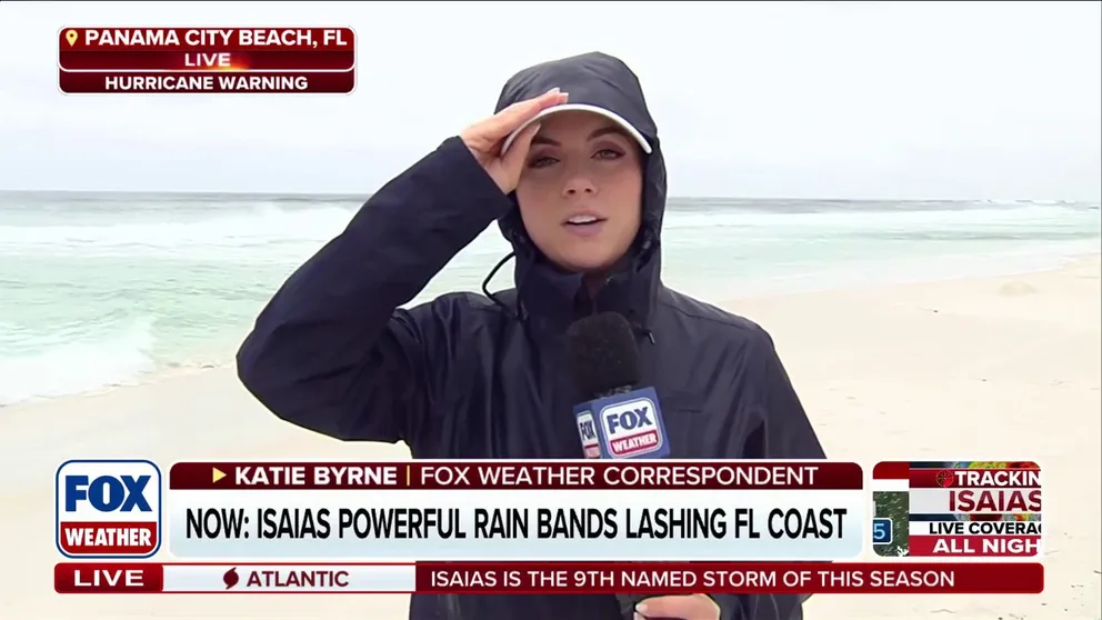
Panama City residents preparing for Hurricane Isaias' life-threatening storm surge
Surfers are taking advantage of the rough waves before conditions get too dangerous in Panama City. Residents are in full preparation mode ahead of Hurricane Isaias' landfall tonight. FOX Weather Correspondent Katie Byrne brings us the latest on emergency preparations as well as beach conditions.
The National Hurricane Center (NHC) said weather conditions are deteriorating rapidly and urged Gulf Coast residents to seek shelter immediately.
Rain has been lashing parts of the coast for several hours ahead of the storm.
Water levels are rising around Panama City and Apalachicola, Florida, while a storm surge blowout is underway in Mobile Bay, Alabama.
TROPICAL STORM RACHEL TARGETS THE WEST COAST WITH FLOODING RAIN AND GUSTY WINDS
Meanwhile, hurricane-force wind gusts are already battering the Gulf Coast, with weather stations reporting gusts of 72 mph in Orange Beach, Alabama, and 96 mph at Pensacola Bay, Florida.
The Storm Prediction Center has issued a Tornado Watch effective until 9:00 p.m. ET (8:00 p.m. CT) for the Florida Panhandle, extreme southern Georgia, and southeast Alabama.
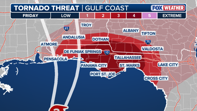
Friday tornado outlook
Florida Gov. Ron DeSantis, Alabama Gov. Kay Ivey and Georgia Gov. Brian Kemp have declared states of emergency ahead of the storm.
In a Friday news conference, DeSantis urged residents to follow evacuation orders due to storm surge.
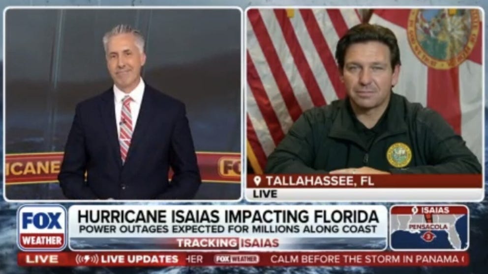
Florida Governor Ron DeSantis joins FOX Weather with an update on Hurricane Isaias
Hurricane Isaias has already started to impact several states along the Gulf Coast including Florida. Governor Ron DeSantis joins FOX Weather Meteorologist Bob Van Dillen to provide an update on how his state is preparing for this dangerous storm.
"The surge is really what puts a lot of people's lives in jeopardy if they haven't heeded evacuation orders and does the most significant damage from these storms," DeSantis said.
"Preparations to protect life and property from storm surge and damaging winds should be rushed to completion in the warning area," the NHC said.
Over a dozen Florida and Alabama counties have canceled school through the end of the week, and multiple colleges have closed their campuses.
Meanwhile, evacuation orders have been issued across parts of Alabama and Florida, including Dauphin Island, Alabama, and Okaloosa and Escambia counties in Florida.
Mandatory evacuation orders have also been issued in Walton County, Florida.
![Hurricane Isaias preparations in Destin, Florida.]() Image 1 of 9
Image 1 of 9Hurricane Isaias preparations in Destin, Florida. (Jarrod Maloney | FOX Weather)
![Hurricane Isaias preparations in Destin, Florida.]() Image 2 of 9
Image 2 of 9Hurricane Isaias preparations in Destin, Florida. (Jarrod Maloney | FOX Weather)
![Blood orange sunset over Pensacola Beach, Florida, on Oct. 8, 2026, a day before the expected landfall of Hurricane Isaias.]() Image 3 of 9
Image 3 of 9Blood orange sunset over Pensacola Beach, Florida, on Oct. 8, 2026, a day before the expected landfall of Hurricane Isaias. (Jarrod Maloney | FOX Weather)
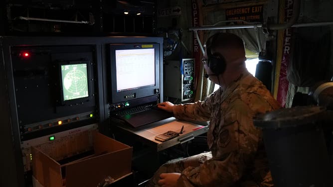
![FOX Weather Correspondent Brandy Campbell joins Hurricane Hunters on reconnaissance mission into then-Tropical Storm Isaias on Oct. 7, 2026.]() Image 4 of 9
Image 4 of 9FOX Weather Correspondent Brandy Campbell joins Hurricane Hunters on reconnaissance mission into then-Tropical Storm Isaias on Oct. 7, 2026. (FOX Weather Correspondent Brandy Campbell)
![FOX Weather Correspondent Brandy Campbell joins Hurricane Hunters on reconnaissance mission into then-Tropical Storm Isaias on Oct. 7, 2026.]() Image 5 of 9
Image 5 of 9FOX Weather Correspondent Brandy Campbell joins Hurricane Hunters on reconnaissance mission into then-Tropical Storm Isaias on Oct. 7, 2026. (FOX Weather Correspondent Brandy Campbell)
![FOX Weather Correspondent Brandy Campbell joins Hurricane Hunters on reconnaissance mission into then-Tropical Storm Isaias on Oct. 7, 2026.]() Image 6 of 9
Image 6 of 9FOX Weather Correspondent Brandy Campbell joins Hurricane Hunters on reconnaissance mission into then-Tropical Storm Isaias on Oct. 7, 2026. (FOX Weather Correspondent Brandy Campbell)
![]() Image 7 of 9
Image 7 of 9Donald Knapp places plywood over the windows of his Islander Ice Cream restaurant as he prepares for the possible arrival of Hurricane Isaias on October 08, 2026 in Gulf Breeze, Florida. (Joe Raedle/Getty Images)
![]() Image 8 of 9
Image 8 of 9David Schisle, Courtney Head, and Donald Knapp place plywood over the windows of Mr. Knapp's Islander Ice Cream restaurant as they prepare for the possible arrival of Hurricane Isaias on October 08, 2026, in Gulf Breeze, Florida. (Joe Raedle/Getty Images)
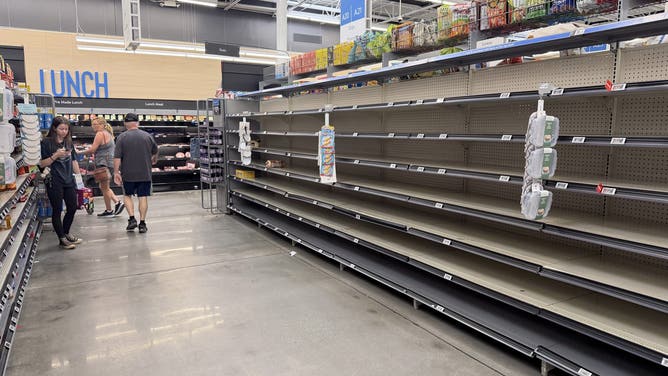
![]() Image 9 of 9
Image 9 of 9The bread aisle in a Walmart store is empty as people stock up ahead of the possible arrival of Hurricane Isaias on October 08, 2026 in Gulf Breeze, Florida. (Joe Raedle/Getty Images)
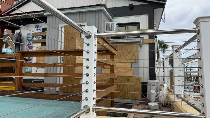
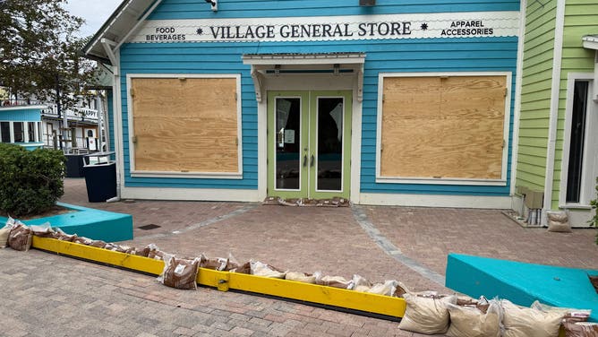
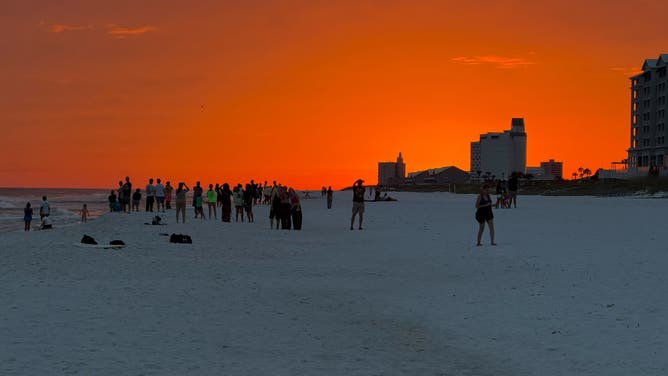



Orange Beach, Alabama, has also issued mandatory evacuations.
"In anticipation of the expected impacts from Tropical Storm Isaias, the cities of Gulf Shores and Orange Beach are encouraging all non‑residents, and residents living in low-lying, flood prone areas to voluntarily evacuate," a statement from city officials said. "City officials urge all individuals who are not permanent residents to leave the area immediately and relocate to a safer location."
Both Shell and Chevron have instituted shut-in production procedures across five of their offshore oil facilities in the Gulf and removed non-essential workers, respectively.
BP said it was also removing non-essential personnel and securing offshore facilities Thursday. ExxonMobil operations are currently normal, but said they are monitoring the forecast closely.
HURRICANE ISAIAS CHURNS IN GULF AS OIL RIGS PREPARE FOR POTENTIALLY DANGEROUS CONDITIONS
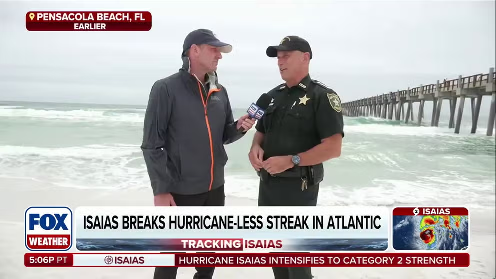
Isaias barrels toward Gulf Coast as dangerous conditions threaten Florida
Hurricane Isaias is barreling toward the Gulf Coast as a powerful Category 2 storm, bringing damaging wind gusts, heavy rain and potentially life-threatening flash flooding. FOX Weather Senior Correspondent Robert Ray is live from Pensacola Beach, Florida, with the ground truth on what residents can expect as the storm approaches.
Hurricane Isaias strengthened from Tropical Storm Isaias late Wednesday night.
WHAT’S THE DIFFERENCE BETWEEN A TROPICAL DEPRESSION, TROPICAL STORM AND HURRICANE?
Isaias rapidly intensified from a tropical storm into a Category 1 hurricane, with winds increasing by 40 mph in just six hours between Wednesday afternoon and late Wednesday night.
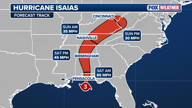
Hurricane Isaias forecast cone.
(FOX Weather / FOX Weather)
Hurricane Isaias' expected impacts
Tropical weather advisories have expanded well inland, across parts of eastern Mississippi, Alabama and southwestern Georgia.
A Hurricane Warning is in effect from Ocean Springs, Mississippi, to the Bay/Gulf County Line in Florida.
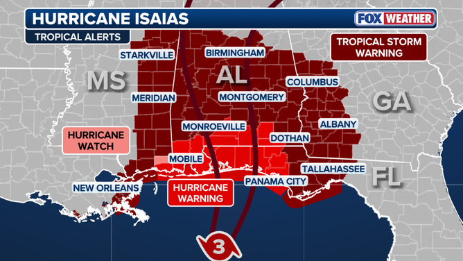
Hurricane Isaias tropical alerts as of 2 p.m. advisory.
Tropical Storm Warnings are in effect just outside Isaias’ forecast cone, bookended by the Jefferson-Plaquemines Parish line in Louisiana to the west and the Aucilla River in Florida to the east.
LATEST FROM FOX WEATHER HURRICANE SPECIALIST BRYAN NORCROSS
A Storm Surge Warning for life-threatening surge is in effect from the mouth of the Mississippi to the Suwannee River in Florida's Big Bend region.
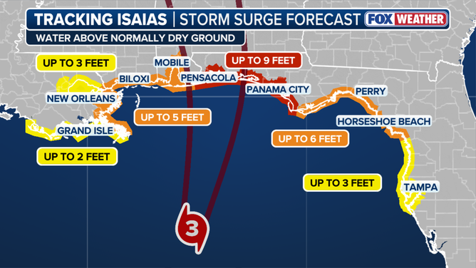
Storm surge forecast
(FOX Weather / FOX Weather)
"There is a danger of life-threatening inundation, from rising water moving inland from the coastline, during the next 36 hours in the indicated locations," the NHC said.
New forecast data from the NHC now calls for up to 9 feet of life-threatening storm surge from the Alabama-Florida to Grayton Beach, Florida.
FOX WEATHER JOINS THE HURRICANE HUNTERS ON CRITICAL RECON MISSION INTO TROPICAL STORM ISAIAS
The Lower Mobile Bay could see up to 5 feet of surge.
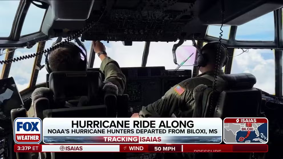
FOX Weather’s Brandy Campbell rides along with Hurricane Hunters as Tropical Storm Isaias strengthens
Tropical Storm Isaias has formed in the Bay of Campeche, and the National Hurricane Center’s forecast shows the storm strengthening into Hurricane Isaias. FOX Weather Correspondent Brandy Campbell is live with NOAA’s Hurricane Hunters as they take flight to investigate the strengthening storm.
Heavy rain is expected to begin Friday morning, with flash flooding, damaging wind gusts, storm surge and even tornadoes possible as the storm comes ashore.
Heavy rain will quickly pick up through the day on Friday from Louisiana to Florida and last through Saturday. FOX Weather Hurricane Specialist Bryan Norcross said some of the strongest impacts will arrive ahead of landfall.
"Bad weather will arrive well in advance of the center, which will cross the coast mid to late evening on the current schedule," Norcross said.
"Thunderstorms are likely along the I-10 corridor this afternoon with the worst weather arriving in the evening."
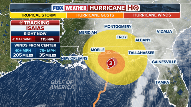
Tropical-storm-force winds: 39- 73 mph, hurricane-force winds: 74 mph+ .
(FOX Weather )
Currently, Isaias is forecast to weaken just before reaching the coast, but the National Hurricane Center said the storm could remain a major hurricane at landfall.
TIMELINE: WHERE TROPICAL STORM ISAIAS IS HEADED AND WHEN IT COULD BECOME A HURRICANE
Norcross said most of the storm's most impactful weather will most likely be on the right side of the storm's center.
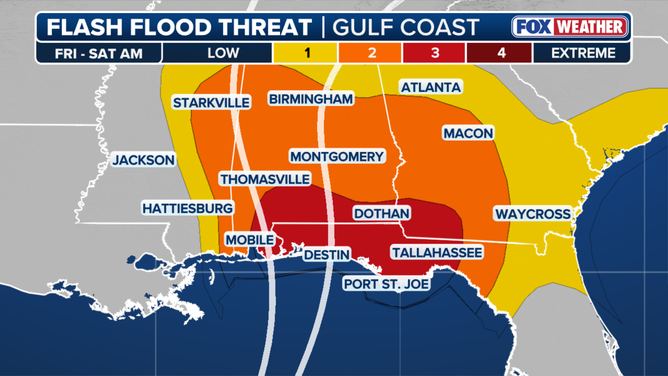
Flash flood threat
(FOX Weather)
NOAA's Weather Prediction Center (WPC) has issued a Level 3 out of 4 flash flood risk for Mobile, Alabama, and the Florida Panhandle west of Panama City. A Level 2 risk includes Atlanta and Montgomery, Alabama, and eventually shifts inland into Saturday to include the Carolinas and Tennessee Valley.
7 FACTS YOU SHOULD KNOW ABOUT FLASH FLOODS
"Rainfall estimates currently show 6 to 10 inches with localized higher amounts of up to 15 inches of rain, which will lead to flash and urban flooding and eventually river flooding," the FOX Forecast Center said.
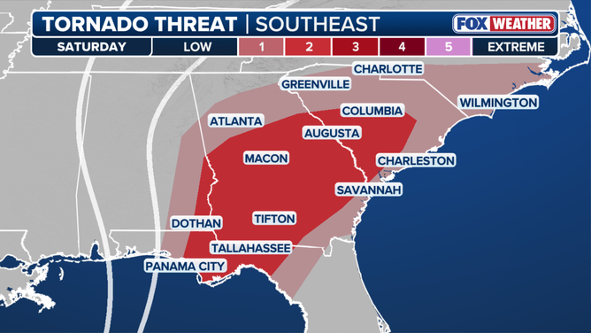
Tornado threat
(FOX Weather)
NOAA's Storm Prediction Center (SPC) has issued a Level 2 out of 5 risk of severe weather for Saturday for tornadoes as the storm's outer bands come ashore. The greatest tornado threat covers parts of southeastern Alabama, the Florida Panhandle and have now been expanded across southern and Central Georgia into southern South Carolina, including Columbia.
TROPICAL STORM ISAIAS CHURNS IN GULF AS OIL RIGS PREPARE FOR POTENTIALLY DANGEROUS CONDITIONS
The system is expected to move inland quickly with heavy rain spreading across the Southeast Saturday, triggering a broad Level 2 flash flood risk from some places along the Mississippi River to the Southeast coast.
This area stretches from Tallahassee north into western North Carolina, to the Southeast coast and into the Tennessee Valley.
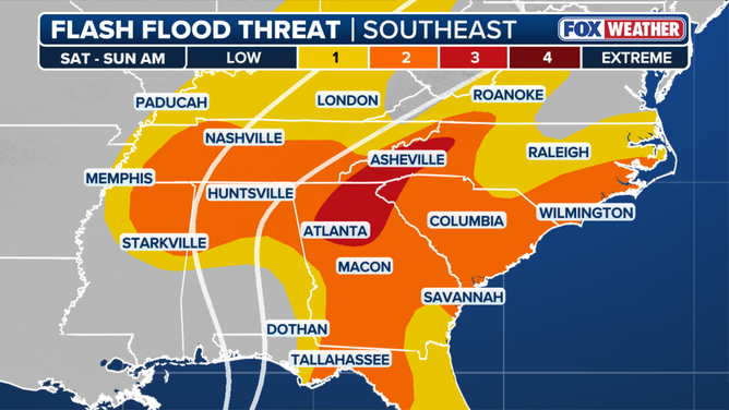
Saturday flash flood threat.
(FOX Weather / FOX Weather)
"The heaviest rain will be across the Carolinas, where 5-8 inches of rain will fall from Charleston to Wilmington," the FOX Forecast Center said.
A High Wind Warning has been issued across parts of northern Alabama, northern Georgia and Western North Carolina beginning Saturday afternoon.
Atlanta could see wind gusts up to 60 mph Saturday.
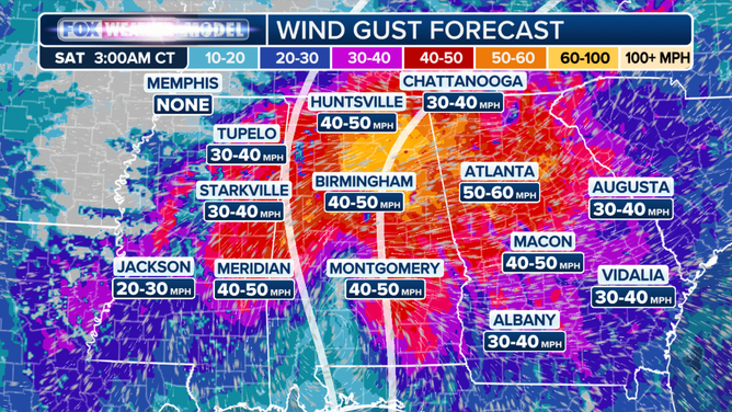
Saturday wind forecast
(FOX Weather)
Rain will spread into the Northeast by Sunday, creating a flash flood risk across parts of the Interstate 95 corridor.
Isaias became the Atlantic season’s first hurricane late Wednesday.
El Niño-driven wind shear has caused a record-slow start to the Atlantic hurricane season, with Isaias becoming the latest first hurricane to form since the satellite era began in 1966.
This story is developing. Check back frequently for updates.