Kansas City threatened by 75+ mph winds as severe threat builds in Plains Friday
As severe thunderstorms progress into Friday evening in the central Plains, they’re expected to transform into a fast-moving line of severe thunderstorms that will likely produce wind gusts of 75 mph or more, threatening Kansas City and Omaha.

Severe weather threat looms in the Plains Friday
Strong to severe thunderstorms could bring damaging winds to Kansas City and Omaha Friday evening as a weather disturbance moves into the Central Plains.
KANSAS CITY, Mo. — The threat of severe weather returns to the central Plains on Friday as a warm and unstable airmass sets the stage to fuel supercell thunderstorms.
A weather disturbance will push out of Colorado and into the High Plains early Friday afternoon, where it will find ample moisture and wind shear to create intense thunderstorms.
Severe Thunderstorm Watches have been posted throughout the Plains as severe thunderstorms develop.
The initial threat will present a risk of tornadoes, damaging wind and large hail along northern and central Nebraska. As the storms progress into Friday evening, they’re expected to transform into a fast-moving line of severe thunderstorms that will likely produce wind gusts of 75 mph or more.

(FOX Weather)
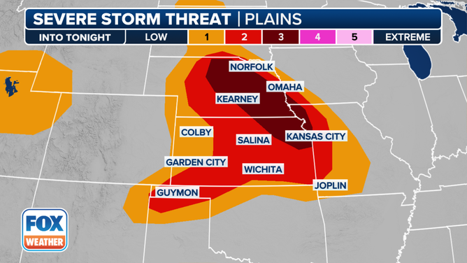
"As the storms track into eastern (Nebraska/Kansas) and western (Iowa/Missouri) during the evening, model guidance suggests the potential for rather widespread damaging winds and hail," NOAA’s Storm Prediction Center wrote Friday morning.
Friday severe weather outlook.
(FOX Weather)
The SPC has since upgraded a swath of that region to a Level 3 out of 5 risk for severe weather Friday, including the Kansas City metro area. Omaha, Nebraska sits on the border, just on the Level 2 side of the severe threat line.
For Kansas City and Omaha, it will be those damaging wind gusts at or more than 75 mph that are the primary threat, along with large hail.
"As we head into the evening, they’ll move into the Kansas City Metro," said FOX Weather Meteorologist Stephen Morgan. "So be in alert if you’re heading out this evening in KC."
Storms will gradually weaken overnight as the line moves into southeastern Kansas and southern Missouri.
Heavy rains prompt flash flooding concerns
In addition to the severe weather, the storms will bring heavy rain across parts of the Central Plains.
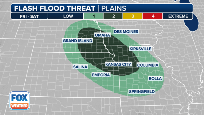
The area near where Iowa, Missouri, Nebraska and Kansas meet could see 3 inches of rain as the storms blow through Friday, with isolated areas of up to 5 inches of rain.
Friday flash flood outlook.
(FOX Weather)
NOAA’s Weather Prediction Center has given the region a Level 2 out of 4 risk for flash flooding.