La Nina climate pattern officially arrives and is expected to persist through winter
Even though La Niña is officially here, NOAA's Climate Prediction Center expects it to remain weak. A weak La Niña is less likely to have a significant impact on weather patterns during the winter and spring.
The meaning of El Nino and La Nina
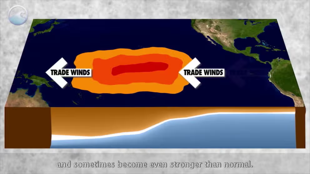
The status of whether the world is being impacted by an El Nino or a La Nina is determined by water temperatures in the central and eastern Pacific. (NOAA)
After months of hearing about the possibility of the world entering a La Niña climate pattern, NOAA's Climate Prediction Center (CPC) announced Thursday that water temperatures in critical parts of the Pacific Ocean had finally reached the threshold required for La Niña to emerge in December.
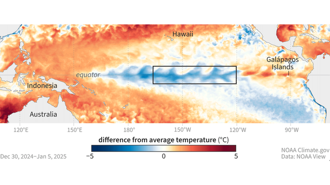
La Niña is considered the cool phase of the El Niño-Southern Oscillation (ENSO) and is characterized by lower-than-average sea-surface temperatures, with anomalies of at least -0.5 degrees Celsius (-0.9 degrees Fahrenheit) over parts of the Central and Eastern Pacific.

Sea-surface temperatures in the Pacific Ocean compared to average for the week of Dec. 30, 2024–Jan. 5 2025. Orange and red areas were warmer than average, while blue areas were cooler than average.
(NOAA Climate.gov)
Officially, Earth last experienced a La Niña event in the spring of 2023 and has been in an El Niño or neutral status ever since.
5 WEATHER EVENTS TO WATCH FOR IN 2025
How long will La Niña last?
"We can make predictions, but it’s impossible to know ahead of time exactly how long La Niña conditions will last," NOAA wrote in its latest blog post declaring the La Niña event.
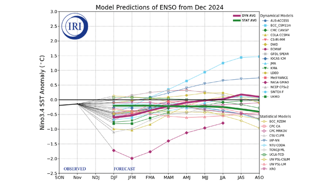
The CPC places the odds at 59% that La Niña will persist through the three-month period spanning February-April 2025.
However, for the following three-month period running from March-May 2025, there's a 60% chance for La Niña to fade with the climate pattern returning to neutral status – neither La Niña or El Niño.
LITTLE-KNOWN WEATHER PATTERN WHEN EL NIÑO AND LA NIÑA ARE NO LONGER IN CONTROL

Forecast of sea-surface temperature anomalies for the critical region of the Pacific Ocean where El Niño and La Niña are monitored.
(The International Research Institute for Climate and Society, Columbia University Climate School)
"That’s not to say it’s impossible for this La Niña to last longer, of course – nature is always full of surprises," NOAA added. "There is a 40% chance for La Niña to persist into March-May 2024."
How will La Niña impact weather patterns in US?
Even though La Niña is officially here, the CPC expects it to remain weak. A weak La Niña is less likely to have a significant impact on weather patterns during the winter and spring.
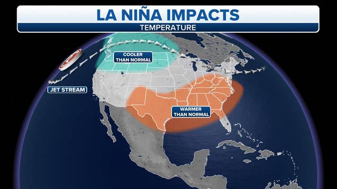
A typical La Niña pattern would usually bring an overall wetter, cooler winter to the northern U.S. and a drier, milder winter to the South.

Typical La Niña weather impacts.
(FOX Weather)
But if the pattern remains weak as expected, there could be fewer kinks in the jet stream, meaning more regional patterns would dominate local weather, with an occasional nudge toward La Niña-favored conditions.
