The arrival of a La Nina has been delayed which could be good news
The neutral state of the El Niño-Southern Oscillation (ENSO) occurs when water temperature anomalies in the eastern and central Pacific are between 0.5 °C and -0.5 °C. The status means neither La Niña or El Niño are in control and is sometimes referred to as La Nada.

NOAA declares El Nino climate pattern dead with flip to La Nina likely
The strong El Niño pattern that had a significant influence on major weather pattern shifts over the past year has come to an end, NOAA announced in its monthly update Thursday.
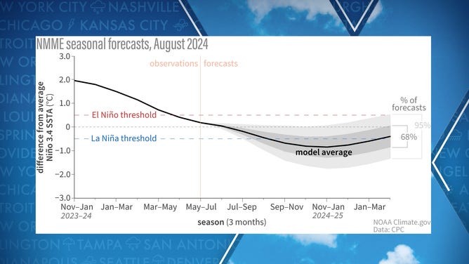
WASHINGTON — New analysis of the El Niño-Southern Oscillation confirms that neutral conditions continue to persist across central and eastern parts of the Pacific, with the chances of transitioning into La Niña decreasing over the next several months.
NOAA released its monthly update on Thursday, noting that parts of the basin had a temperature anomaly of 0.3°C, while other regions were just below zero.
Forecasters indicated that it could be several months before conditions are met for the world to officially enter a La Niña phase, despite a La Niña Watch having been issued in February.
"The expected transition from ENSO-Neutral to La Niña continues to proceed slowly, as if the whole Pacific is stuck in a summer daze, moving as slow as molasses," Tom Di Liberto, a meteorologist at NOAA, stated in a recent blog entry.
The basin currently remains in a neutral state of ENSO, characterized by water temperature anomalies between 0.5 °C and -0.5 °C.
The status means neither a La Niña nor an El Niño is in control and the stage is sometimes referred to as a La Nada.
Water temperatures in the eastern Pacific
(NOAA)
Once water temperatures reach -0.5 °C or colder, the world would be considered to be in a La Niña phase; however, that threshold is not expected to be reached anytime soon.
NOAA has put the odds of a La Niña developing during the September through November period at 66% and raises the odds to 74% during the upcoming winter.
Pockets of cooler water temperatures below the ocean’s surface and enhanced trade winds give meteorologists confidence that a La Niña will eventually emerge, albeit somewhat delayed.
Complicating factors could include climate change, but how it is directly impacting the ENSO cyclone remains unclear.
Graph showing observed and predicted temperatures of the Pacific
(NOAA)
LITTLE-KNOWN WEATHER PATTERN WHEN EL NINO AND LA NINA ARE NO LONGER IN CONTROL
Delayed onslaught of La Nina has beneficial ramifications
The fact that the country has made it through the bulk of the growing season without the emergence of a La Niña might give farmers cause for celebration.
La Niña patterns typically lead to drier growing conditions and more extreme weather events. Without these patterns affecting America's heartland, crops such as corn and soybeans have enjoyed banner months not seen in years.
The favorable weather also sets the country up for an important fall season, where apples and pumpkins will soon become topics of conversation.
In addition to the cross-country impacts, the neutral state of the ENSO means that the peak of the hurricane season will not occur during a La Niña event.
La Niñas tend to increase the chances of tropical cyclone formation in the Atlantic basin due to warmer water and less vertical wind shear.
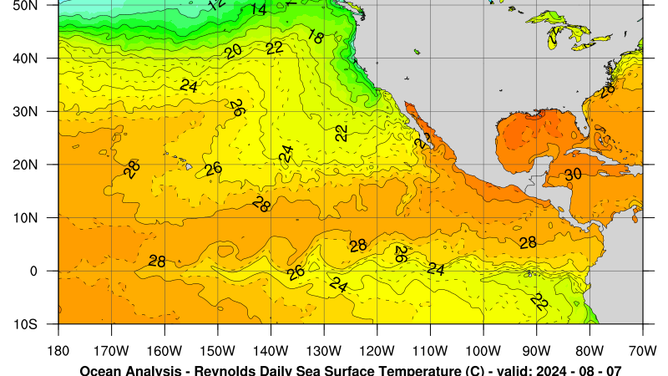
Despite the absence of a current La Niña, water temperatures across most of the Atlantic have remained at record levels, potentially offsetting the impacts of not being in the most conducive phase of the ENSO.
Tropical weather experts at Colorado State University recently released an updated hurricane outlook and are forecasting fewer storms than in their previous predictions.
Despite expectations of 23 named cyclones, the amount is still significantly higher than the production of 14 tropical storms during an average season.
"While there is uncertainty with all seasonal outlooks, the forecast team has higher confidence than usual that this season will be extremely busy," CSU forecasters stated.
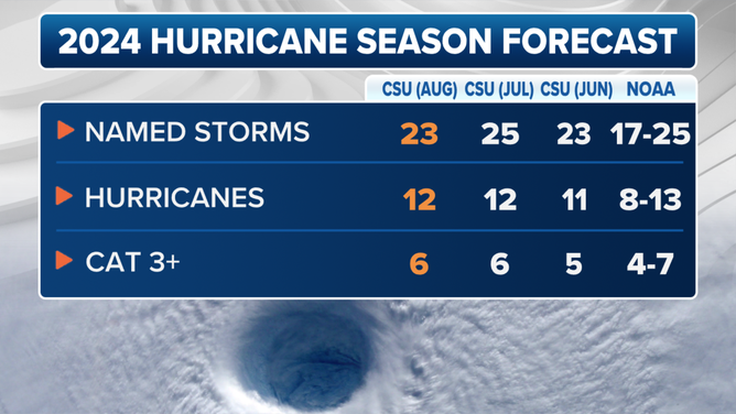
This graphic shows the updated 2024 Atlantic hurricane season forecast as of Aug. 6, 2024.
(CSU / FOX Weather)