Could La Nina arrive too late to have much influence on hurricane season?
Water temperatures in the central Pacific Ocean have been holding steady near long-term average levels during the past month instead of exhibiting much of any cooling trend that would be expected in a budding La Niña.

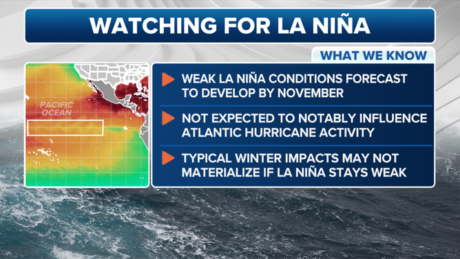
Weak La Nina is late, but expected to arrive and persist through the winter
Water temperatures in the central Pacific Ocean have been holding steady near long-term average levels during the past month instead of exhibiting much of any cooling trend that would be expected in a budding La Niña.
COLLEGE PARK, Md. – La Niña is still running late, and when it does get here, it may not stick around very long. But while that might seem like it could help at least limit one factor that was expected to enhance this year’s hurricane season, the underlying data suggests La Niña may still have a say in giving the tropics a boost.
Water temperatures in the central Pacific Ocean have been holding steady near long-term average levels during the past month instead of exhibiting much of any cooling trend that would be expected in a budding La Niña.
Meteorologists with NOAA’s Climate Prediction Center said the El Niño-La Niña weather-related patterns are also indicative of those tropical Pacific water temperatures near average — known as the "neutral" phase of the "El Niño Southern Oscillation Cycle" - or ENSO.
WHAT DOES THE ‘NEUTRAL’ PHASE MEAN IN THE EL NINO-LA NINA CYCLE?
All signs still point to La Niña… eventually
But computer forecast models still see signs of La Niña and predict the tropical Pacific waters will continue to cool this autumn. They give a 71% chance of reaching La Niña status by November – a slight uptick in confidence from last month – with a weak La Niña phase holding through winter.
Earlier this year, when La Niña was trending toward a much earlier arrival, it was seen as a potential additional boost to this year’s hurricane season. La Niña periods typically come with decreased wind shear over the Gulf of Mexico and Atlantic basin, giving more favorable conditions for tropical storms and hurricanes to thrive. Combined with persistent record-warm ocean temperatures in that region, the recipe was there for a "hyperactive" hurricane season.
Instead, so far, the hurricane season has ended up close to an average season for a variety of unusual reasons. But the peak of the season is this week, meaning there is still nearly half a season to go. Officially, hurricane season goes until Nov. 30, with October usually another active month in the tropics.
Could La Niña now be too late and too weak to be much of a contributing factor? If the cycle remains neutral through the bulk of the hurricane season into October, it would seem to have less influence on the overall hurricane season.
But there are other signs La Niña is lurking closer to reality. Newer research that aims to subtract out the overall warming of the tropics over the past several years from climate change shows that, relatively speaking, that region of the tropics is currently closer to having more of a La Niña-type influence than the traditional measurements would indicate.
Dr. Phil Klotzbach, a hurricane expert with Colorado State University, said that even a late-arriving La Niña or a "La Niña" that comes up just short could still combine with above-average water temperatures and other factors to produce an active late season in some waters.
"Broadly speaking, even if we don't officially get to La Niña, the likely cool neutral ENSO combined with the extremely warm Caribbean could lead to a busy late season in the Caribbean," he said.
In the general sense, seasons that have remained in neutral conditions have run the gamut from just a handful of storms to being one of the most active on record.
According to research conducted by experts at Florida State University, impacts from hurricanes during neutral years are heightened for the Florida Peninsula and Gulf of Mexico and are similar to what’s produced by La Niña sequences.
The East Coast tends to experience reduced tropical cyclone activity, while the Caribbean sees impacts that are considered to be around average.
Why is La Niña behind schedule?
According to forecasters at NOAA, long-term climate forecasts such as the La Niña/El Niño cycle are still susceptible to multiple factors. This season's La Niña forecast has had two primary challenges, NOAA said.
The first is short-term weather events that can complicate seasonal predictions.
"For example, just a few periods of weaker trade winds can delay surface cooling (of the waters of the tropical Pacific)," University of Miami Research Associate Professor Emily Becker wrote for NOAA's Climate.gov blog Thursday. "Unfortunately, predicting such short-term variations is an ongoing challenge, and currently we can only predict these trade wind fluctuations a week or so in advance."
The second, Becker said, is overall climate change and the warming oceans in general.
"The global ocean temperatures are still way above average, and they are predicted to drop only slightly over the next several months," she wrote. "We don’t yet have a clear picture of how global warming may affect ENSO in general, or the development of La Niña this year in specific."
Overall, though, the models’ prediction of La Niña this upcoming winter has been consistent, giving climate forecasters confidence La Niña is eventually coming.
What about the rest of the US?
If La Niña conditions do arrive in time for winter, that would usually bring an overall wetter, cooler winter to the northern US and a drier, milder winter to the South.
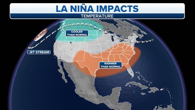
La Niña weather impacts in the U.S.
(FOX Weather)
But with now a weak La Niña expected, the pattern may not have as much of a significant influence. In that case, if neutral phase conditions hold, there are fewer kinks in the jet stream, meaning more regional patterns dominate local weather.