Hurricane Ian Ieft scars visible from space along its trail of destruction
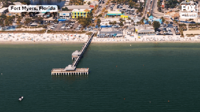
Several well-known landmarks, including the Fort Myers Pier and Sanibel Island Causeway, fell victim to Ian's deadly storm surge, satellite images show.
Before-and-after photos show Hurricane Ians' devastation in Florida
Pictures taken from space before and after Hurricane Ian show the devastating impacts the storm had on Southwest Florida.
FORT MYERS, Fla. – As Hurricane Ian made its trek across the Gulf of Mexico, through Florida and eventually into South Carolina, it left many visible scars along its path.
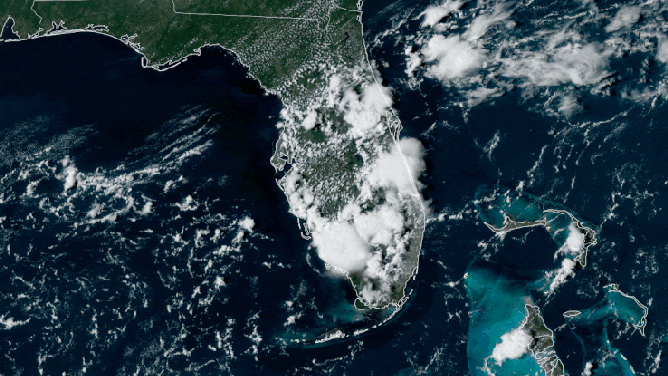
Even before Ian reached Florida, it was reshaping the regional landscape, leaving a clear trail along the eastern Gulf of Mexico.
Satellite imagery from GOES-16 Friday afternoon shows waters just off the southwestern Florida coast in a mix of bright teal and muddy brown.
Compare to what the waters looked like 10 days earlier when conditions were considerably calmer:
GOES-16 images showing Florida waters on Sept. 20 before Hurricane Ian and on Sept. 30 after Ian passed showing how much sediment was churned in the Gulf of Mexico.
(NOAA / CIRA / RAMM-B)
Hurricane Ian’s 155-mph winds churned up the waters of the eastern Gulf of Mexico as it swirled between Cuba on Tuesday and its eventual landfall near Fort Myers, Florida, on Wednesday.
The waters are relatively shallow in those areas, and dirt and sediment from the raging waves above were churned to the surface, discoloring the water to an extent it was visible from 22,000 miles above in space.
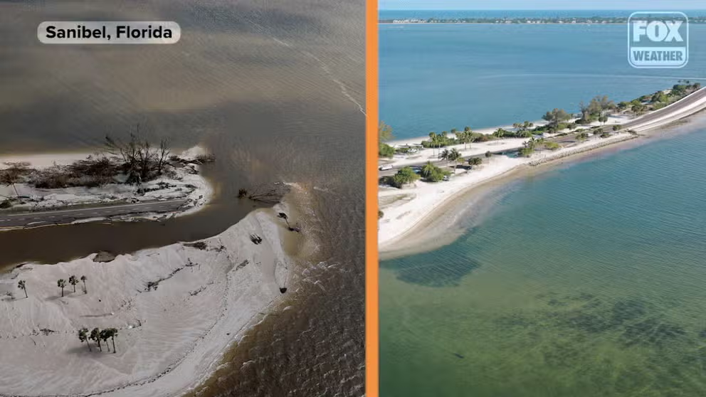
Roads washed away and landmarks destroyed
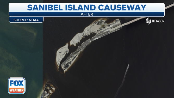
![Sanibel Island Causeway before Hurricane Ian.]() Image 1 of 6
Image 1 of 6Sanibel Island Causeway before Hurricane Ian. ( )
![Sanibel Island Causeway after Hurricane Ian.]() Image 2 of 6
Image 2 of 6Sanibel Island Causeway after Hurricane Ian. (Image: NOAA) ( )
![Sanibel Island Causeway before Hurricane Ian hit.]() Image 3 of 6
Image 3 of 6Sanibel Island Causeway before Hurricane Ian hit. ( )
![Sanibel Island Causeway after Hurricane Ian.]() Image 4 of 6
Image 4 of 6Sanibel Island Causeway after Hurricane Ian. (Image: NOAA) ( )
![Captiva Island before Hurricane Ian.]() Image 5 of 6
Image 5 of 6Captiva Island before Hurricane Ian. (Image: NOAA) ( )
![Captiva Island after Hurricane Ian.]() Image 6 of 6
Image 6 of 6Captiva Island after Hurricane Ian. (Image: NOAA) ( )


NOAA's National Geodetic Survey is collecting aerial damage assessment images in the aftermath of Ian using NOAA aircraft and NOAA satellites.
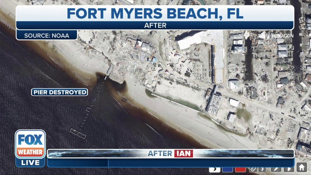
Several well-known landmarks including the Fort Myers Pier, Captiva Island and Sanibel Island Causeway fell victim to Ian's deadly storm surge.
A closer look via aerial damage assessments found only remnants of the historic Fort Myers Beach Pier remained after Ian's storm surge and wind power.
Aerial images show the extent of the damages to the Fort Myers Beach Pier from Hurricane Ian.
Parts of the Sanibel Island Causeway were wiped out by the hurricane, and the Pine Island Bridge is also impassable.
Before and after satellite photos from Florida coast
Satellite images show before and after the impacts of Hurricane Ian
Lights out

NOAA and NASA's Suomi NPP satellite shows where power outages remained in Florida after Hurricane Ian.(Image: NOAA/NASA)
At its peak, Hurricane Ian caused more than 2 million Florida customers to lose power. Utility companies have now been able to restore many people. However, full restoration could take weeks for areas with major infrastructure damage.
The NOAA/NASA Suomi National Polar-orbiting Partnership (NPP) satellite shows power outages near Fort Myers, Florida into Central Florida after Hurricane Ian's landfall.
Below is a look at Hurricane Ian from NOAA's GOES East satellite as the storm approached South Carolina for landfall. The lack of Florida's lights at night are a good indicator of power outages that remained in Southwest Florida on Friday.
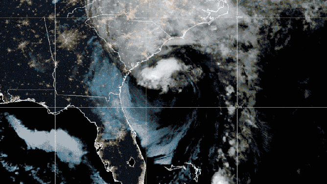
NOAA's GOES EAST Satellite shows Hurricane Ian in true color during nighttime and daytime ahead of South Carolina landfall on Sept. 30, 2022. and (Image: NOAA)