Much-needed rain triggers mudslides, debris flows in Los Angeles burn-scar areas
The Los Angeles Fire Department said it responded to reports of a debris flow in Woodland Hills, trapping several vehicles in the mud and other debris that rushed down the hillside.
California rain helps short-term fire threat, sets off mudslides in burn scar areas
Southern California received some much-needed rainfall over the last two days, which helped with the ongoing wildfire fight across the Los Angeles area. However, the return of the rain triggered Flash Flood Warnings, mudslides and debris flows in burn-scar areas, forcing officials to close roads and schools in the region.
LOS ANGELES – Southern California received some much-needed rainfall over the last two days, which helped with the ongoing wildfire fight across the Los Angeles area. However, the return of the rain triggered Flash Flood Warnings, mudslides and debris flows in burn-scar areas, forcing officials to close roads and schools in the region.
"It was a beneficial rain for many folks across Southern California, but it really doesn't take a whole lot, especially in the burn-scar areas, for significant problems," said Ariel Cohen, meteorologist-in-charge at the National Weather Service office in Los Angeles.
Watch: Los Angeles Fire Department truck stuck in mud
Video shared by FOX 11 in Los Angeles shows firefighters trying to dig out a fire truck after it became stuck in mud after heavy rain in Southern California on Sunday, Jan. 26, 2025.
The precipitation arrived in Southern California on Sunday, and while no blockbuster rainfall totals were reported, it was enough to cause numerous issues across the region.
The Los Angeles Fire Department said it responded to reports of a debris flow in Woodland Hills, trapping several vehicles in the mud and other debris that rushed down the hillside.
Videos showed first responders working to remove the stuck vehicles, as well as firefighters who were seen trying to dig out a Los Angeles Fire Department truck that also became stuck.
Watch: Widespread rain returns to Los Angeles area
A video shared from Studio City shows heavy rain falling as forecaster warn of potential mudslides and debris flows in recent wildfire burn scar areas.
Flood Advisories were put into effect across a large portion of the region, including for part of the burn scars from the Palisades and Eaton fires, but they expired Monday morning.
Moderate rain was reported by the National Weather Service office in Los Angeles, and forecasters said places expected to experience flooding included Malibu, Chatsworth, Woodland Hills, Calabasas, Pacific Palisades and surrounding areas.
A video shared from Studio City showed the beneficial rain arriving Sunday, helping the short-term wildfire fight that has been ongoing since the historic and deadly wildfires broke out at the start of January. As of Tuesday, 29 fire-related deaths have been reported by the Los Angeles Department of Medical Examiner.
Because of the conditions, officials closed all four Malibu schools on Monday to ensure the safety of students and staff. Classes will resume on Tuesday.
Watch: First responders work to free vehicles stuck in mud in California
A video shared by FOX 11 in Los Angeles shows first responders working to free vehicles that became trapped in mud after heavy rain in Southern California triggered mudslides and debris flows in recent burn-scar areas on Sunday, Jan. 26, 2025.
Beaches were also dangerous as the storm impacted the region, with forecasters issuing a Beach Hazards Statement early Monday morning warning of potential lightning strikes on beaches in San Diego County between Camp Pendleton and Del Mar.
That warning has since been allowed to expire.
The Los Angeles County Department of Public Health has also advised beachgoers to avoid all contact with water, especially near discharging storm drains, creeks and rivers due to potentially higher bacteria levels in those areas.

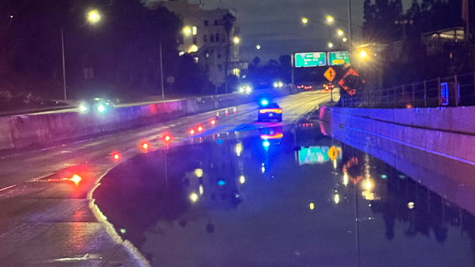
This image shows flooding on the 101 Freeway in Los Angeles on Monday, Jan. 27, 2025.
(@CHPCentralLA/X / FOX Weather)
In Los Angeles, the California Highway Patrol (CHP) said a portion of the 101 Freeway was shut down early Monday morning due to flooding on the roadway. Officials said the heavily traveled highway would be closed until the flooding subsided, and traffic was being diverted. The road has since reopened.
Watch: Vehicles on I-5 escorted across Grapevine summit due to snow
A video shared by Caltrans District 7 shows crews placing sand on Interstate 5 as snow falls.
A large section of Interstate 5 was also closed, but not because of flooding. Heavy snow was reported in the higher elevations, causing major travel issues in the area. Caltrans shared a video showing crews working to drop sand on the roadway, with a parade of vehicles behind them, ahead of the arrival of snow.
I-5 was closed in the Tejon Pass area from Castaic in Los Angeles County to Grapevine in Kern County due to dangerous winter weather conditions. The CHP said I-5 reopened in both directions Monday afternoon after several hours of closure. Drivers were advised not to rush or speed, as the road was still slick.


