South Carolina wildfires force residents to flee homes as blazes erupt along Eastern Seaboard
South Carolina Gov. Henry McMaster issued a state of emergency on Sunday in response to the wildfires burning across the state. The South Carolina Department of Environmental Services recommends that anyone with respiratory health problems stay indoors and limit exposure to smoke.

Fire danger grows across Carolinas as National Guard joins containment efforts
Multiple wildfires erupted along the East Coast over the weekend, forcing evacuations and prompting widespread firefighting efforts. Fires have been reported from the Delmarva Peninsula and New Jersey shore to the Carolinas and Georgia.
MYRTLE BEACH, S.C. – Multiple wildfires erupted along the East Coast over the weekend, forcing evacuations and prompting widespread firefighting efforts. Fires have been reported from the Delmarva Peninsula and New Jersey shore to the Carolinas and Georgia.
Some of the larger wildfires were reported in areas such as Mott State Park in New Jersey, Polk County in western North Carolina and Horry County in South Carolina.

Watch: National Guard battles forest fire in Horry County, South Carolina
The South Carolina National Guard has deployed to combat a growing wildfire in Horry County's Carolina Forest, utilizing aerial water drops as increased fire danger warnings are issued due to expected high winds and low humidity.
South Carolina Gov. Henry McMaster issued a state of emergency on Sunday in response to the wildfires burning across the state.
An air quality alert was put into place for Horry County on Monday until further notice due to fine particulates in the air from the wildfire ash and smoke.
MYRTLE BEACH RESIDENTS DODGE FLAMES WHILE FLEEING WILDFIRE: 'WHAT IF WE CAN'T GET OUT?'
The South Carolina Department of Environmental Services recommends that anyone with respiratory health problems stay indoors and limit exposure to smoke.
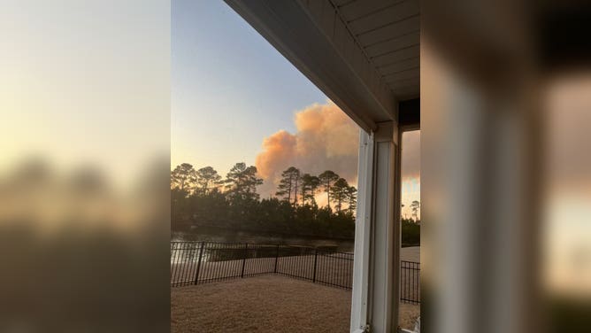
![Smoke outside of wildfire in South Carolina]() Image 1 of 6
Image 1 of 6Smoke outside of wildfire in South Carolina (@richards_texas)
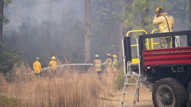
![MYRTLE BEACH, SOUTH CAROLINA - MARCH 2: Firefighters battle a blaze in the Carolina Forest neighborhood on March 2, 2025 in Myrtle Beach, South Carolina. Multiple forest fires in the area have caused evacuations along the South Carolina coast.]() Image 2 of 6
Image 2 of 6MYRTLE BEACH, SOUTH CAROLINA - MARCH 2: Firefighters battle a blaze in the Carolina Forest neighborhood on March 2, 2025 in Myrtle Beach, South Carolina. Multiple forest fires in the area have caused evacuations along the South Carolina coast. (Sean Rayford)
![MYRTLE BEACH, SOUTH CAROLINA - MARCH 2: Firefighters battle a blaze in the Carolina Forest neighborhood on March 2, 2025 in Myrtle Beach, South Carolina. Multiple forest fires in the area have caused evacuations along the South Carolina coast.]() Image 3 of 6
Image 3 of 6MYRTLE BEACH, SOUTH CAROLINA - MARCH 2: Firefighters battle a blaze in the Carolina Forest neighborhood on March 2, 2025 in Myrtle Beach, South Carolina. Multiple forest fires in the area have caused evacuations along the South Carolina coast. (Sean Rayford)
![Winnabow Volunteer Fire Department battles one of many brush fires in New Jersey.]() Image 4 of 6
Image 4 of 6Winnabow Volunteer Fire Department battles one of many brush fires in New Jersey. (Winnabow Volunteer Fire Department)
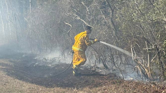
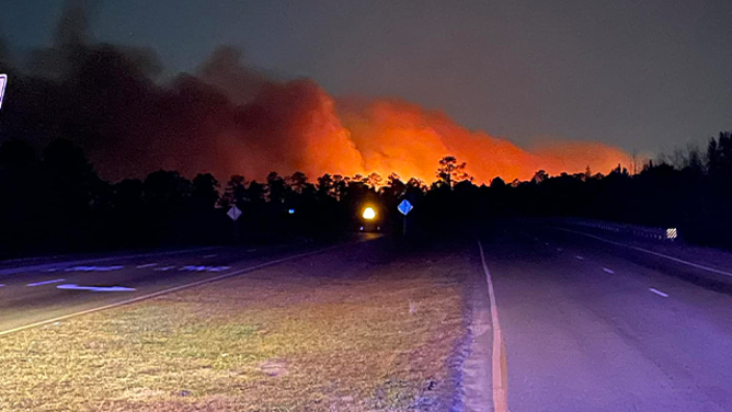
![This photo shows flames illuminating the night sky as a wildfire rages in Horry County, South Carolina.]() Image 5 of 6
Image 5 of 6This photo shows flames illuminating the night sky as a wildfire rages in Horry County, South Carolina. (horrycountyfirerescue/Facebook)
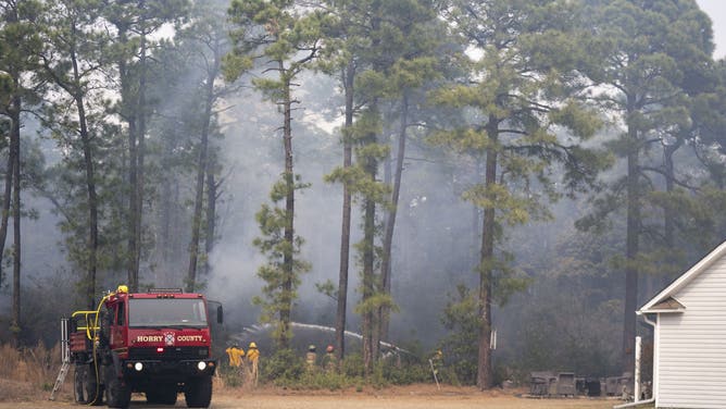
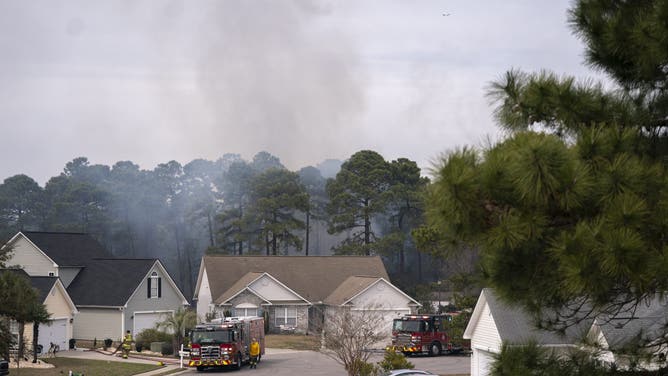
![MYRTLE BEACH, SOUTH CAROLINA - MARCH 2: Smoke rises behind homes as firefighters battle a blaze in the Carolina Forest neighborhood on March 2, 2025 in Myrtle Beach, South Carolina. Multiple forest fires in the area have caused evacuations along the South Carolina coast.]() Image 6 of 6
Image 6 of 6Smoke rises behind homes as firefighters battle a blaze in the Carolina Forest neighborhood on March 2, 2025 in Myrtle Beach, South Carolina. (Sean Rayford)
Horry County fire officials advised residents of thick smoke that is likely to severely limit visibility on roads around Horry County into Tuesday morning.
"The fewer vehicles on the road, especially when emergency apparatus are responding to the Carolina Forest-area wildfire incident and other emergency calls, the safer everyone is," they said in a Facebook post.
The FOX Forecast Center warned that the combination of low humidity, gusty winds and dry vegetation increased the danger of fires spreading out of control. Relative humidity values were reported to be between 15% and 30%, while wind gusts of up to 40 mph allowed the fires to grow quickly.
Horry County fire officials ordered evacuations in the Carolina Forest area due to rapidly spreading wildfires. Residents were directed to seek safety at the Carolina Forest Recreation Center, and the South Carolina National Guard dispatched Blackhawk helicopters to combat the blazes.
The South Carolina Forestry Commission reports that while the Blackthorn Drive Fire (800 acres) is contained, the larger Covington Drive Fire (2,059 acres) in Horry County is 30% contained. So far, no injuries have been reported.

Watch: South Carolina wildfire seen from airplane over Myrtle Beach
Video captured Saturday showed the fires burning near Myrtle Beach from an airplane. The fire has since spread to 1,600 acres, officials said.
Evacuation notices were issued where homes were close to flames, such as in the Grand Strand of South Carolina and the western region of North Carolina, including the community of Tryon, North Carolina. At this time, local authorities have not reported any destroyed homes from the fires.
Several of the wildfires occurred in areas where the remnants of Hurricane Helene had knocked over trees and other vegetation, causing increased concerns for erratic fires.
WATCH: FEDEX JET ENGINE BURST INTO FLAMES AFTER BIRD STRIKE OVER NEWARK

Watch: Wildfire rages in Carolina Forest, South Carolina
This video shared from South Carolina shows smoke from a wildfire filling the sky as the blaze rages in Carolina Forest on Saturday, March 1, 2025.
Winds tapered off Monday, providing temporary relief before another frontal boundary moves into the region during the middle part of the workweek. The next system is expected to arrive on Wednesday and bring much-needed precipitation to an area that has been plagued by a lack of rainfall for months.