Severe weather threat slices through 16 states along 1,300-mile path from Gulf Coast to Minnesota on Tuesday
This renewed risk of severe thunderstorms follows a deadly month of extreme weather across the region, from tornado outbreaks in the Plains to a derecho that tore across the Houston area.
Severe weather threat increases in Plains on Tuesday
Tens of millions of people from the Gulf Coast to Minnesota are at risk of seeing severe weather on Tuesday, but NOAA's Storm prediction Center has highlighted an area of the Plains with a higher risk of seeing powerful storms.
Tens of millions of people along a 1,300-mile stretch of the country from the Gulf Coast to the U.S.-Canada border in Minnesota will be at risk of severe weather Tuesday, with the main threats being large hail, damaging wind gusts and torrential rain that could lead to flash flooding.
This renewed risk of severe thunderstorms follows a deadly month of extreme weather across the region, from tornado outbreaks in the Plains to a derecho that tore across the Houston area.
Happening now

(FOX Weather)
Because of the threat, Severe Thunderstorm Watches stretch from Minnesota through Louisiana.

(FOX Weather)
At least 16 states are at risk of seeing severe thunderstorms on Tuesday, but NOAA’s Storm Prediction Center (SPC) has highlighted a few areas of the U.S. that are seeing a higher threat.
On Tuesday afternoon, the SPC placed portions of Oklahoma in a Level 3 out of 5 on its 5-point severe thunderstorm risk scale.
This threat zone includes cities like Oklahoma City, Norman, Edmond, Midwest City and Moore.
More than 22 million people in 10 states from the Gulf Coast to Minnesota are been included in a Level 2 out of 5 threat.
This includes cities like Dallas in Texas, Kansas City in Missouri, Omaha in Nebraska, Tulsa in Oklahoma and Minneapolis in Minnesota.
WATCH VS. WARNING: HERE ARE THE DIFFERENCES BETWEEN THESE WEATHER TERMS THAT COULD SAVE YOUR LIFE
Significant risk of flash flooding in South

(FOX Weather)
NOAA’s Weather Prediction Center (WPC) upgraded parts of Oklahoma, northeastern Texas, southwestern Arkansas and northwestern Louisiana to a Level 3 out of 4 risk of excessive rainfall that could lead to flooding on Tuesday.
This is because forecasters are concerned that those areas will likely see two rounds of rain and storms during the day and into the afternoon and evening hours.
The ground in that region remains extremely saturated from rounds of torrential rain over the past several weeks, and rivers and streams are still running high.
Therefore, the risk of flooding remains elevated in those regions.
The WPC has also placed a large part of the country in a Level 2 out of 4 risk of excessive rainfall that could lead to flooding on Tuesday. Those are the same areas at risk of severe weather.
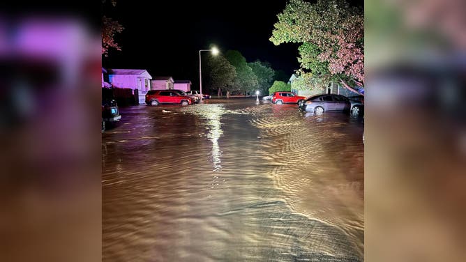
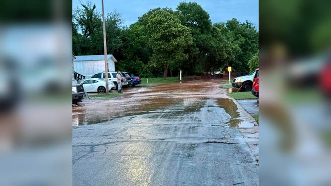
Flash flooding has already been an issue for parts of Oklahoma.
The Cleveland County Sheriff's Office posted photos to Facebook and said emergency crews responded to reports of flooding on the east side of Sunny Lane Estates in Norman.
According to the Facebook post, residents needed to be rescued from their homes due to the high water levels.
"While there has been property damage in the area, we are thankful no major injuries have been reported," the sheriff's office said.
FLOOD WATCH, WARNING AND EMERGENCY: HERE ARE THE DIFFERENCES THAT COULD SAVE YOUR LIFE
Power outages, damage reported

(FOX Weather)
The severe weather and flash flood threat comes after a line of powerful thunderstorms swept across areas of Texas and Louisiana on Monday night, producing hurricane-force wind gusts and knocking out power to more than 100,000 utility customers.
Many parts of East Texas were hit hard with power outages, including Cass, Titus, Smith, Rusk and Panola counties – many of which remain.
And more than 25,000 outages remain in Louisiana after storms rolled in.
Both Henderson and Lindale in Texas saw wind gusts as strong as a Category 1 hurricane.
Winds were whipping in Tyler, Texas, too, with the SPC receiving reports of numerous downed trees and power lines due to the storms.


