Deadly winter storm pushes into Northeast after slamming Midwest with heavy snow, ice
This latest storm system also brought rounds of severe weather to the South, where at least one tornado was spotted amid a slew of Tornado Warnings that were issued across the region on Wednesday.

Snow, ice snarl Thursday morning commute in Northeast as deadly winter storm continues cross-country trek
A powerful and deadly winter storm that slammed the Plains and Midwest on Wednesday moved into the Northeast on Thursday morning where it impacted the morning commute due to snow and ice across the region.
Fast Facts:
- Child killed in Missouri crash; plane slides off runway at St. Louis Lambert International Airport.
- Northeast and New England mark the final stop of deadly storm’s cross-country trek.
- FOX Forecast Center tracking weekend storm bringing renewed risk of winter weather and severe weather to millions.
BOSTON – A powerful and deadly winter storm that slammed the Plains and Midwest on Wednesday has pushed into the Northeast and New England, where it dumped a wintry mess of snow, sleet, freezing rain and rain that led to slow travel on area roads and highways Thursday.
This latest storm system also brought rounds of severe weather to the South, where at least one tornado was spotted amid a slew of Tornado Warnings that were issued across the region on Wednesday.
The storm is now in its final act and will exit the Northeast later Thursday, but the FOX Forecast Center is continuing to monitor a weekend storm system that will bring a renewed risk of severe weather in the South and winter weather in the Northeast.
Crashes snarl Thursday morning commute in Northeast

(FOX Weather)
The winter storm in the Northeast brought some tricky travel to the region for the Thursday morning commute, and officials have urged drivers to keep it slow on the roads or just stay home until conditions improve, if possible.
Crews have been out in full force across the region, both pretreating roads ahead of the storm and working to remove snow and ice from roads and highways.
Schools in several states have announced that they will either open late to give crews more time to work on the roads or will remain closed on Thursday.
Numerous crashes were reported in New England, including Maine, where officials were forced to shut down the Maine Turnpike in Ogunquit. The Maine Turnpike Authority said in a Facebook post that at the request of Maine State Police, speeds on the Maine Turnpike from the New Hampshire state line to the end of the turnpike at Mile 109 were reduced to 45 mph because of the snow.
(FOX Weather)
Winter weather alerts remain in effect across portions of northern New England, and a Winter Storm Warning remains in effect for portions of northern Maine until late Thursday night.
Plains, Midwest feel full force of deadly winter storm

Watch: Visibility reduced on Kansas highways during powerful winter storm
A video shared by the Douglas County Sheriff's Office shows treacherous travel conditions due to heavy snow that fell during a winter storm early Wednesday morning.
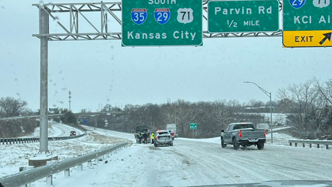
As the storm was gaining strength while it moved across the central U.S., snowfall rates of up to an inch per hour produced several inches of snow accumulations along its path, including 2-3 inches of snow in the Kansas City, Missouri, area.
The winter storm’s early impacts in Kansas and Missouri made for treacherous driving on Wednesday morning.
At least one deadly crash was reported in Missouri on Wednesday. The Missouri State Highway Patrol said a rollover crash claimed the life of a 3-year-old girl near Holts Summit on U.S. Highway 54.
Elsewhere across the state, troopers reported numerous crashes and stuck vehicles, including a crash that blocked Interstate 35 in Clay County.
This image shows a crash on Interstate 35 in Clay County, Missouri, on Wednesday, Feb. 12, 2025.
(Trooper Norris/@MSHPTrooperA/X / FOX Weather)
In neighboring Kansas, state police also responded to numerous reports of crashes, including one that injured a person near Junction City.
In Missouri, a GoJet Airlines Flight 4427 slid off a taxiway after landing at St. Louis Lambert International Airport Wednesday morning, according to the FAA. Officials noted that passengers evacuated the aircraft and were transported to a terminal.
The airport was reporting 27 degrees with snow and freezing fog during the time of the incident.

Watch: Powerful winter storm produces thundersleet in Oklahoma
A video shared from Norman, Oklahoma, shows bright lightning illuminating the sky during a powerful winter storm sweeping across the Plains and Midwest. Thundersnow and thundersleet was reported in Oklahoma early Wednesday morning.
Thundersnow was also reported in Oklahoma City and Norman, Oklahoma, early Wednesday morning.
Snow spread northeastward into the Great Lakes area on Wednesday evening, including Chicago, Milwaukee and Detroit.
About 5-7 inches of snow fell in Milwaukee, making it the city's biggest snowfall of the season so far. Farther south in Chicago, 1.5 inches of snow was reported downtown as of late Wednesday, while totals of 2-3 inches were measured in the outer suburbs.

Michiganders ice skate as winter storm brings snow to the Midwest
Snow has begun to fall in Michigan, where FOX Weather Correspondent Brandy Campbell reports while on ice skates. She speaks with two Grand Rapids residents and fellow ice skaters about how they've enjoyed the recent snowfall.
On the eastern shore of Lake Michigan, FOX Weather Correspondent Brandy Campbell spoke to Michiganders excited by the recent snow in Grand Rapids.
"I'm good with having more snow," one resident said. "As long as it doesn't go over a foot, then we're good."
After seeing about 2 inches of snow, plow operators in Grand Rapids were busy clearing the streets on Thursday.

FOX Weather's Brandy Campbell clears streets with snow plow in Grand Rapids, Michigan
FOX Weather Correspondent Brandy Campbell hops on a snow plow in with operator Lanita Godwin in Grand Rapids, Michigan as snow continues to fall across the Midwest on Thursday. More than 2 inches fell on Wednesday creating slippery road conditions.