Why the National Hurricane Center's forecast cone may look a little different this year
The NHC states that the new forecast cone overall will be 3 to 5% smaller compared to last year’s, as prediction errors have improved in recent years.
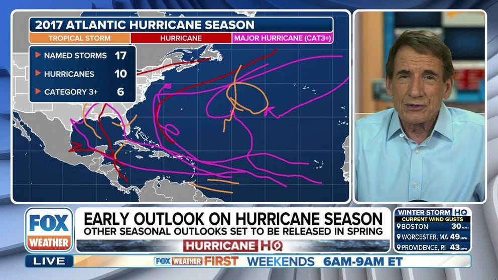
Sneak preview of upcoming hurricane season with FOX Weather's Bryan Norcross
FOX Weather Hurricane Specialist Bryan Norcross breaks down what early global computer models indicate for the upcoming tropical weather season and if there might be any surprises.
MIAMI - The iconic forecast cone used by the National Hurricane Center to predict the paths of tropical cyclones is set to undergo its annual update, with forecasts indicating that the product's size will shrink in 2025 due to decreasing errors in forecast tracks.
The NHC states that the new forecast cone overall will be 3 to 5% smaller compared to last year’s, as prediction errors have improved in recent years.
First used during the 2002 season, the forecast cone is made up of a series of forecast circles that represent the probable track of a cyclone's center over a specific period of time.
The cone is revised annually, taking into account forecast track errors from the past five years, and identifies the most likely area where the center of circulation could follow.
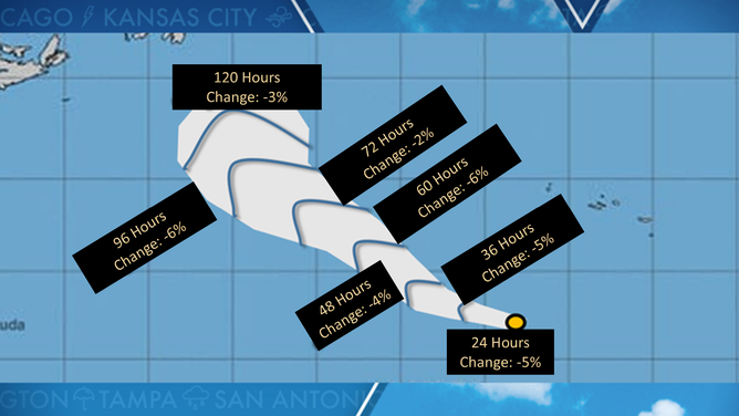
The size of the tropical cyclone forecast error cone for 2025 will be about 3-5% smaller for systems in the Atlantic basin and 5-10% smaller for systems in the eastern Pacific. The greatest reduction is at the 96-hour mark where the cone's width will decrease by 6%.
The updated forecast cone is about 45 miles wide around forecast hour 24 and up to 245 miles wide during hour 120.
Despite the enhanced accuracy, hurricanes only track within the cone about two-thirds of the time, with the remaining third veering outside the cone, prompting updated forecasts.
2025 cone of uncertainty
(FOX Weather)
2025 ATLANTIC HURRICANE SEASON GUIDE
Even with the forecast improvements, hurricane experts note that the cone is not without its flaws and is generally misunderstood by much of the public.
Some forecasters warn that a focus on the cone itself can detract attention from the broader impacts of a storm, such as storm surge, flooding and winds, which can extend well beyond the cone’s boundaries.
There have been instances when a storm has veered off the center of the cone, catching residents off guard. Notable examples include Hurricane Charley in 2004 and Hurricane Ian in 2022, where small deviations in the storm’s path led to large differences in where the storm made landfall along the Florida coastline.
Another challenge created by the forecast cone, according to experts, is the potential for a "cry wolf" scenario in certain areas.
Some metropolitan areas are often placed under the cone but may not experience significant damage, which can result in residents becoming complacent and potentially underestimating future threats.
To address the incorrect notion that dangers only exist within the forecast cone, the NHC added inland watches and warnings to an experimental product in 2024, which will be used again in 2025.
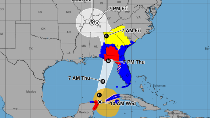
Hurricane cone example
(NOAA)
Along with the smaller cone, the NHC will introduce further enhancements in the 2025 hurricane season, which begins on June 1.
These changes include an increased emphasis on rip current risks and the earlier issuance of potential tropical cyclone alerts.
The updates are aimed at improving preparedness for emergency managers and residents, helping them take action sooner and more effectively ahead of tropical weather events.
Despite its challenges, the NHC has maintained that the forecast cone is a vital tool in hurricane forecasting, with continued updates and refinements helping to improve preparedness and response in the face of increasingly unpredictable tropical weather.
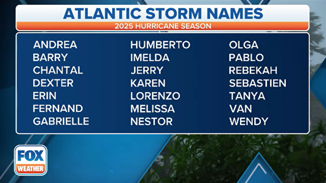
2025 Hurricane Season Names
(FOX Weather)