NOAA's new astronomical spring weather outlook paints a familiar tune
Forecasters from the National Oceanic and Atmospheric Administration issued their 2025 U.S. Spring Outlook, which calls for above-average temperatures for most of the country, while drought conditions continue in the Southwest.

Astronomical spring weather outlook
Forecasters from NOAA’s Climate Prediction Center have released their best guesses for what the climate will look like during meteorological spring which runs through June 20.
Forecasters from NOAA’s Climate Prediction Center have released their best predictions for what the climate will look like during astronomical spring, which runs through June 20.
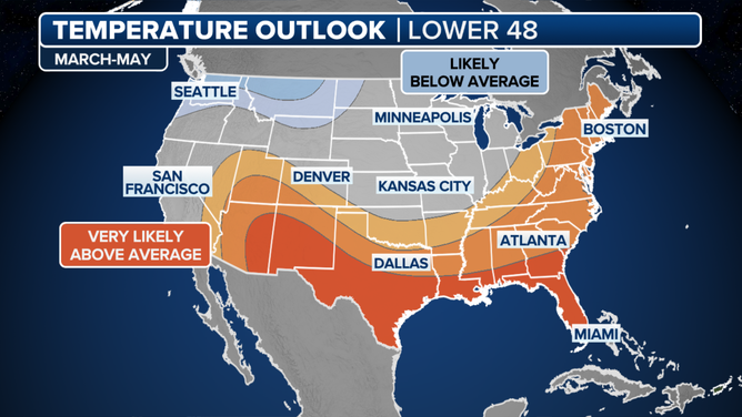
The key takeaways from the outlook are largely unsurprising: above-average temperatures are expected across much of the country, with ongoing drought conditions in the Southwest.
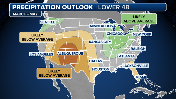
Due to the warmth and dryness, a large portion of the U.S. is also expected to experience a reduced risk of widespread flooding along major rivers.
"The Spring Outlook provides critical information for our partners — including those in agriculture, shipping, and recreation — allowing them to prepare for what’s ahead this spring and maximize their economic potential," Ken Graham, director of NOAA’s National Weather Service, said in a statement.
The areas most likely to see increased precipitation are confined to the Great Lakes and the Pacific Northwest.
Due to the increased cloud cover associated with rainy weather, these regions are also expected to have the best chances of experiencing average or even below-average temperatures.
![March-June temperature outlook]() Image 1 of 2
Image 1 of 2March-June temperature outlook ( )
![March-June precipitation outlook]() Image 2 of 2
Image 2 of 2March-June precipitation outlook ( )
WHEN WILL THE CHERRY BLOSSOMS PEAK IN WASHINGTON THIS SPRING?
NOAA forecasters do not expect La Niña or El Niño to play a significant role in weather patterns this spring, meaning localized weather patterns will have a more substantial impact than any nationwide climate event.
The neutral status of the El Niño-Southern Oscillation, or what is sometimes referred to as "La Nada," is characterized by water temperature anomalies in the eastern and central Pacific that fall between 0.5°C and -0.5°C.
ENSO-neutral conditions are not typically associated with an active spring severe weather season, although air temperatures are generally warmer across the nation as a whole.
NOAA reports that moderate-to-exceptional drought conditions currently affect about 40% of the continental U.S., exacerbated by a lack of significant snowfall during the previous winter.

Latest U.S. drought map
Many northern regions experienced double-digit snowfall deficits, as winter storm systems lacked the moisture needed to provide communities with the snow they rely on for a significant portion of their annual precipitation.
Further south, areas such as the Southwest, Florida and the Southeast are expected to remain at heightened fire danger until significant precipitation arrives - which likely won’t happen until after the start of meteorological summer.
IS THERE A WEATHER PHENOMENON KNOWN AS THE ATLANTIC NINA?
Meteorological summer begins on June 1 and runs through August, while astronomical summer will begin with the summer solstice on Friday, June 20, at 10:41 p.m., and lasts through the fall equinox on September 22, 2025.
Meteorological seasons are based on calendar months, as it provides a more straightforward way for forecasters to compare weather patterns.
Astronomical seasons, however, are based on the position of Earth and the Sun and do not account for meteorological patterns.
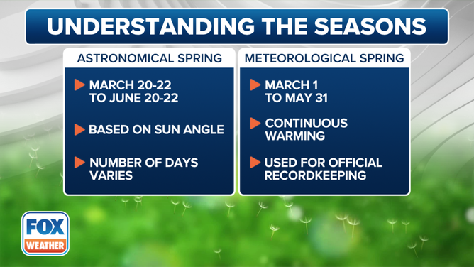
The start of spring depends on whether you're referring to the astronomical or the meteorological start.
(FOX Weather)