Is spring coming early? NOAA predicts lingering La Nina to impact weather across US through May
While meteorological spring begins March 1, spring's official arrival is on March 20 in the Northern Hemisphere. Here's a closer look at NOAA's predictions for the season.
Why spring should actually begin on March 1
Meteorologists and climatologists define the seasons differently than what your calendar shows.
The transition of La Niña to a neutral El Niño pattern in the coming months is expected to play a big role in how spring unfolds in the U.S.
According to NOAA, the effects of La Niña will linger into spring and have an impact on precipitation and temperature patterns across the country.
While meteorological spring begins March 1, spring's official arrival is on March 20 in the Northern Hemisphere. Here's a closer look at NOAA's predictions for the season.
Temperature outlook
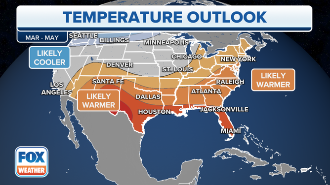
NOAA expects the nation's southern tier to have the greatest chance of above-average warmth. Much of the eastern U.S. is also expected to be warmer than average.
Meanwhile, a colder-than-average spring is predicted from the Pacific Northwest through portions of the northern Rockies and northern Plains. Below-normal temperatures are also favored for southeastern Alaska.
Spring temperatures are expected to be near average along the West Coast and in the central Rockies, Central Plains, upper and mid-Mississippi Valley and western Great Lakes.
NOAA said areas depicted in gray are regions that have equal chances for above-, near- or below-normal seasonal temperatures.

NOAA expects the nation's southern tier to have the greatest chance of above-average warmth.
(FOX Weather)
Precipitation outlook
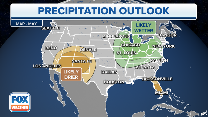
Areas forecast to have the greatest chances for below-average precipitation during the spring extend from southeastern California and southern Nevada into much of the already-parched Four Corners region. Florida is also expected to have drier weather this spring. Below-normal precipitation is also favored for the southeastern coast of mainland Alaska and for the Alaska Panhandle.
Above-average precipitation is predicted across the Midwest, Great Lakes, mid-Atlantic and mid-South.
The remainder of the U.S., NOAA said, will have equal chances of below-, near- or above-average seasonal precipitation.

Areas forecast to have the greatest chances for below-average precipitation during the spring extend from southeastern California and southern Nevada into much of the already-parched Four Corners region.
(FOX Weather)
Drought outlook
About 41% of the contiguous U.S. is in some type of drought, according to NOAA. This is about 3% less than a month ago.
Drought is expected to develop or persist in much of the Southwest, the Florida peninsula and the Southeast coast, according to NOAA.
The agency predicts drought conditions to improve likely or be removed in the next three months in the Northwest and in parts of the northern and central Great Plains, as well as Michigan.

(FOX Weather)
Seasonal outlooks: Hit or miss?
NOAA produces seasonal outlooks to help the nation prepare for likely weather and climate patterns during the next few months to help minimize negative impacts on lives and livelihoods.
HOW ON-TARGET ARE SEASONAL OUTLOOKS?
Since 1995, many of the seasonal temperature outlooks have ranged between zero and 40 on the Heidke Skill Score (HSS) – a score of 100 means the outlook was perfect. Only three times has the HSS come in at 80 or above, depicting nearly pinpoint accuracy.
In the winter of 2020-21, both temperature and precipitation outlooks came in below zero, indicating more inaccuracies than precisions in the outlook.
Are you tired of weather apps with endless numbers that offer no context or help to understand the weather? Put the power of over 100 meteorologists and the worldwide resources of FOX in your hands with the free FOX Weather app. See and interact with the forecast for today and 14 days into the future, along with hourly details for the next 48 hours.
