What is a Miller Type A nor'easter?
A Miller “Type A" storm originates in the Gulf of Mexico and impacts the Eastern Seaboard.
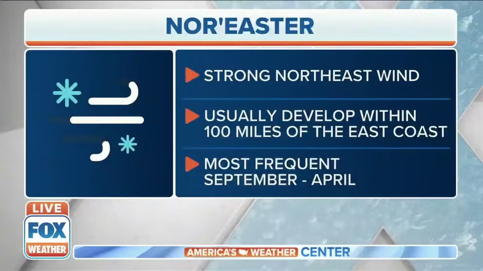
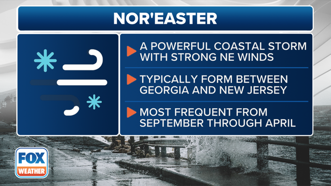
What is a nor'easter?
FOX Weather meteorologist Kendall Smith explains what a nor'easter is.
Nor’easters are powerful storm systems that impact the Eastern Seaboard with a combination of northeasterly winds, heavy precipitation and coastal flooding.
These storm systems, which typically occur in the autumn and winter months, form when cold air over the continental United States clashes with warm, moist air from the Gulf of Mexico, the Atlantic Ocean and the Gulf Stream.
The resulting event can produce blizzard conditions, hurricane-force wind gusts, severe weather and significant coastal erosion.
Meteorologists classify nor’easters using the Miller classification system, named after researcher J.E. Miller, from the 1940s.
Originally, only two types of storms - Miller Type A and Miller Type B – were used for identification purposes, but in the early 2000s, forecasters expanded the system to include three additional types, creating five distinct categories: Type A, Type B, Type C, Type D and Type E.
Each type of nor’easter has unique characteristics and impact zones that can lead to devastating conditions, with widespread power outages and billions of dollars in damage.
This is the definition and criteria of a nor'easter.
(FOX Weather)
What is a Miller Type A nor’easter and who does it impact?
This event happens when a strong polar jet dips southward and meets a low-pressure system that develops in the Gulf of Mexico or southwest Atlantic.
The system’s origin point is often a frontal boundary that is draped across the Gulf Coast and Florida.
As the low moves up the Eastern Seaboard, the system usually rapidly intensifies with significant snowfall likely in the mid-Atlantic and into areas of the interior Northeast.
Due to the system’s trajectory, large chunks of the I-95 corridor tend to miss out on the heavy snow, with rainfall that cuts down on accumulation rates.
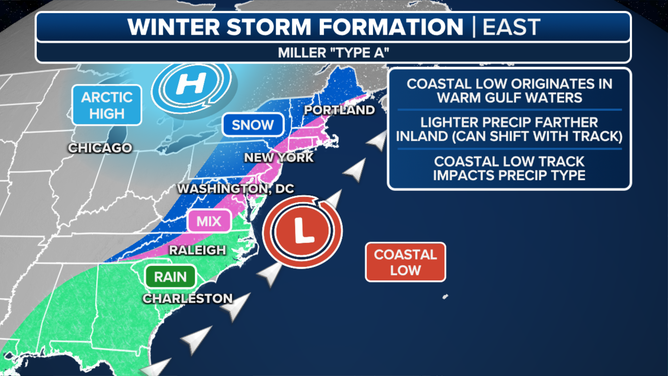
This graphic explains Miller Type A nor’easters.
(FOX Weather)
Miller Type A events are more common during La Niña patterns than during El Niños because the northern jet tends to be more energized than the southern subtropical jet.
Some of the most powerful storm systems outside of hurricanes have been Miller Type A storms.
The Superstorm of 1993, a Miller Type A event, was the most destructive nor’easter in U.S. history.
Known as the "Storm of the Century," the system produced hurricane-force wind gusts, tornadoes, flooding and blizzard conditions that led to the deaths of more than 300 people with damage amounts in the immediate aftermath of the event estimated to be at more than $5 billion.
Historical examples of Miller Type A nor’easters
December 22-24, 1989: Christmas Coastal Snowstorm
A storm system that developed in the Gulf of Mexico and traveled along the southeastern coastline produced a once-in-a-lifetime snowfall event for communities in the Deep South.
Enough cold air was in place that instead of rain or severe weather, cities from Florida through the coastal Carolinas saw record snowfall.
According to NOAA historical data, 15" of snow fell in Wilmington, North Carolina, while 3.9" fell in Charleston and Jacksonville saw around 2".
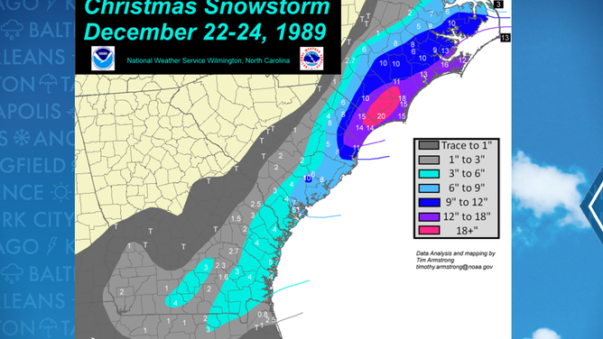
Christmas week snowstorm of 1989 map
(FOX Weather)
According to the NWS, the frozen weather event caused widespread power outages and severe crop damage as arctic temperatures gripped the region for days.
Winds were reported to be 60 mph and wave heights were between 25-35 in the near-shore waters from Virginia into the Carolinas.
Virginia and the Delmarva Peninsula were the northernmost extent of the impactful weather, as the system took a path out to sea and did not make a swipe at the Northeast.
March 12-14, 1993: Storm of the Century
A low-pressure system developed on March 12th along a nearly stationary front along the Gulf Coast.
The system, dubbed the "Storm of the Century," produced hurricane-force wind gusts, tornadoes, flooding and blizzard conditions across much of the eastern third of the nation.
During its trek from the Gulf Coast along the Eastern Seaboard, the system’s barometric pressure dropped to as low as 960 mb, which is the equivalent of a Category 3 hurricane.
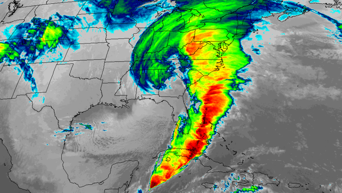
Satellite image of the 1993 Superstorm
(NOAA)
Widespread wind gusts of more than 70 mph knocked power out to at least 10 million residents, with an estimated 120 million in the impact zone.
The heaviest snowfall occurred in the Appalachians with 1-2 feet reported from North Carolina through interior Pennsylvania and New York.
The combination of gusty winds and heavy precipitation caused every major airport on the U.S. East Coast to close at some point during the storm system.
While the coastal storm of 1989 demonstrated the limited impact a Miller Type A nor’easter can have, the "Storm of the Century" showcased the opposite extreme, highlighting the vast reach and intensity such a system can achieve.
According to NOAA, the storm system led to the deaths of more than 300 people, with damage tallies in the immediate aftermath of the event estimated to be at more than $5 billion.
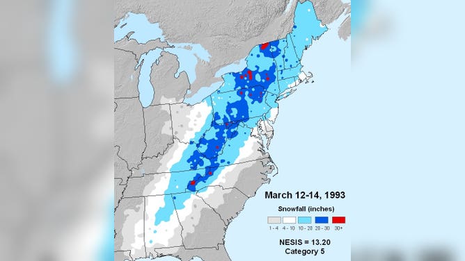
Snowfall map accumulation from March 1993
(NOAA)
December 18-20, 2009: North American Blizzard of 2009
The nor’easter developed during the weekend before Christmas along the Gulf Coast and caused impacts along the Appalachians and southern parts of the Northeast and New England.
Its track led to significant snowfall from the Appalachians through Long Island, with some communities reporting more than 2 feet of snow.
Wind gusts of 40-50 mph triggered Blizzard Warnings to be issued from around the nation’s capital to Long Island.
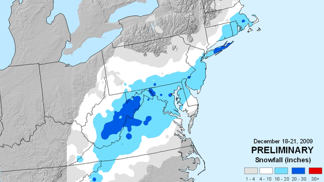
Snowfall map accumulation from December 2009
(FOX Weather)
Parts of the Southeast, including Georgia and the Carolinas, experienced extreme icing, which halted travel.
Based on NOAA’s impact scale, the storm system only ranked as a 2 out of 5 based on precipitation amounts and population impacted.
The event was quickly followed by the 2009 North American Christmas blizzard, which produced more widespread impacts across a greater extent of the country and received a rating of 5 - the most extreme on its impact scale.