New England coast to be smacked by whipping winds, gnarly waves as storm approaches region
Swimmers should be prepared for an increased risk of rip currents during the final days of July and the first days of August.

Summer coastal storm to whack New England with strong wind, rough surf
A coastal storm is approaching New England and is expected to bring strong winds, rough surf and rain to the region as we close out the weekend and get ready for a new workweek.
The FOX Forecast Center is keeping its eyes on an area of low pressure off the East Coast of the U.S. that’s expected to approach New England as we close out the weekend, bringing the risk of strong winds, rough surf and precipitation that could ruin beach plans across the region.
While the majority of the Northeast and New England will remain dry, coastal communities such as Boston and Cape Cod in Massachusetts and even Portland, Maine, might experience a few scattered showers as we start the new week.

Watch: Exclusive FOX Model Futuretrack shows coastal storm approaching New England
The exclusive FOX Model Futuretrack shows a strong coastal storm approaching New England on Sunday and Monday.
Rainfall totals over the next five days are expected to be modest, with less than an inch likely. However, more concerning to forecasters will be the strong winds and waves, which are anticipated to create rough beach conditions.
Coastal conditions could be similar to what a tropical depression or a weak tropical storm might produce but without the low-pressure system actually earning a name.
2024 ATLANTIC HURRICANE SEASON GUIDE: HERE’S WHAT TO KNOW ABOUT THIS YEAR’S STORMS
Chance of tropical development?
Forecasters aren't concerned about tropical development because the system is expected to spend only a few hours over warm waters before moving over ocean temperatures in the 60s and 70s – temperatures too cool for tropical cyclone formation.
As an upper-level low, the transition into a tropical or subtropical system typically takes several days, a timeframe the system is not expected to have.
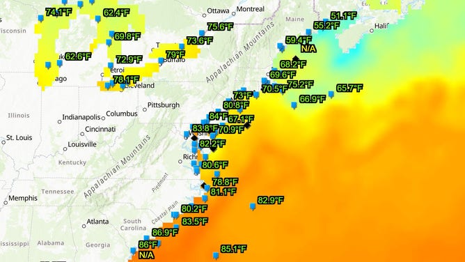
East Coast water temperatures.
(NOAA)
If the low were to remain over water temperatures in the upper 70s to lower 80s for several days, the National Hurricane Center would likely monitor the area for potential tropical development, but that is not anticipated this go-around.
The impacts are not diminished by the system not becoming a tropical system. Waves and seas are expected to make any waterway dangerous for swimmers and boaters.
Computer forecast models predict winds gusting up to 40 mph along the Cape, while other areas in southeastern Massachusetts and Rhode Island could experience gusts in the 20-30 mph range.

(FOX Weather)
Unpleasant beach weather
The increased motion in the ocean, as well as the gusty winds, could help to pile up water close to the shore, leading to the hidden danger of rip currents.
These hidden threats form when waves break near the shoreline, causing water to pile up and create a narrow, fast-flowing stream that swiftly carries swimmers away from shore.
Many inexperienced swimmers run into trouble by attempting to fight against the outgoing force of water instead of swimming parallel to the shoreline.
To alert beachgoers of threats, many lifeguard organizations use color-coded flags to warn swimmers of the dangers.
WHAT DO THE DIFFERENT FLAGS AT THE BEACH MEAN?

(FOX Weather)
A green flag indicates a low threat of hazardous conditions, while a double red flag means the water is closed to the public.
A day of rough ocean conditions usually results in lifeguards hoisting red flags, warning of the hazardous conditions and alerting inexperienced swimmers to stay out of the water.
National Weather Service forecasters were concerned that warm air temperatures might drive people into the water for extended periods of time, leading to hypothermia.
"The warm air temperatures in the upper 70s and lower 80s may cause people to underestimate the dangers of the very cold water temperatures. Water temperatures are currently only in the upper 50s to near 60 degrees along the Hancock County coast and low to mid 50s along the Washington County coast," forecasters stated.