First snow of season falls over Northeast mountains as cold blast invades eastern US
Cities such as Chicago, Cincinnati and Philadelphia, which are used to seeing temperatures in the 60s to near 70 degrees this time of year, are expected to struggle to reach the mid-50s for highs during the first half of the workweek.

Over 200 million Americans feeling chill this week
What had been an exceptionally warm October across nearly all the Lower 48 now feels like a distant memory after a cold front caused temperatures to plunge by 5-15 degrees as we approach the start of a new workweek.
What had been an exceptionally warm October across nearly all the Lower 48 now feels like a distant memory after a cold front caused temperatures to plunge by 5-15 degrees as we start a new workweek.
The cold air is invading regions such as the Midwest, mid-Atlantic and Northeast, where snow showers are even possible in higher elevations.
A dusting of snow fell over Saranac Lake, New York, on Monday morning, with snowflakes observed outside the Hotel Saranac in the quaint Adirondack village.

First snow of season falls across Adirondack Mountains on Monday morning
Check out this EarthCam from Saranac Lake, New York, on Monday morning as the area sees light snow blanketing the ground.
Additional footage taken by Chris Luft shows light snow falling on nearby Lake Placid, New York, on Monday morning.

Early season snow falls on Lake Placid
Parts of northern New York received early season snow showers on Monday morning, as a cold front moved through.
Cities such as Chicago, Cincinnati and Philadelphia, which are used to seeing temperatures in the 60s to near 70 degrees this time of year, are expected to struggle to reach the mid-50s for highs during the first half of the workweek.
Most areas are expected to remain dry, but locations downwind of the Great Lakes face the chance for light rain showers, which could mix with snow in the higher elevations of the Northeast and New England.

(FOX Weather)
The large-scale weather pattern will allow for gusty winds off the warm lakes, creating lake-effect rain and snow showers.
Computer forecast models show that those closest to lakes Erie and Ontario in New York, Pennsylvania and Ohio will be in store for the most precipitation, but again, those at lower elevations will experience all rain, as the cloud cover and warm water temperatures will help keep air temperatures above the freezing mark.
The cold air is expected to make its way to the Eastern Seaboard and the Interstate 95 corridor, where cities such as Boston, New York and Washington will all struggle to make it out of the 50s on Wednesday and Thursday.
HERE’S WHEN TO EXPECT THE FIRST FREEZE OF THE SEASON
The cold air is expected to cause overnight temperatures to reach the freezing point in large parts of Wisconsin, the Appalachians and along the U.S.-Canadian border.
The air mass generally falls in line with expectations for when to anticipate the first significant cooldown of the season.
Large parts of the Midwest, Great Lakes and New England typically experience their inaugural freeze during the first half of October, with the majority of the country seeing its first freeze from late October into early November.
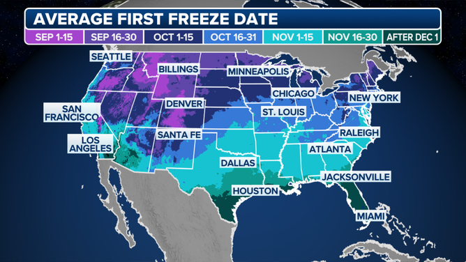
Average first freeze.
(FOX Weather)
The first frost and freeze of the year signify the end of the growing season, as cooler temperatures can damage or kill tender plants.
Local National Weather Service offices have an arsenal of weather alerts that meteorologists can issue ahead of the chilly weather.
When temperatures are expected to remain generally above freezing but cold enough to produce a thin layer of ice, a Frost Advisory is issued.
Ahead of an event where temperatures are expected to drop to 32 degrees or below during the next 24-48 hours, meteorologists will issue a Freeze Watch, which will turn into a Freeze Warning as the event approaches.
These alerts are mainly used for agricultural purposes and advise people on the appropriate safeguards to protect vulnerable plants and crops.
MOST ANTICIPATED COMET OF THE YEAR MAKES CLOSEST APPROACH TO EARTH
Unlike cold air masses later in the season, the coming cooldown doesn’t appear to have staying power.
Computer forecast models show a round of above-average temperatures gaining hold in the Upper Midwest by Thursday and reaching the East Coast by the end of the upcoming weekend.
An area of high pressure centered over the eastern U.S. and western Atlantic will help ensure that easterly to southerly breezes send temperatures 5-15 degrees above average, which could last for a substantial portion of the remaining days of the month.

(FOX Weather)