'Pineapple Express' among trio of atmospheric river events impacting California for days
Flood Watches are in effect for more than 12 million people, including the San Francisco Bay Area and Sacramento, through Sunday evening as the first of three atmospheric river storms impacts Northern California over the next several days.

Trio of atmospheric rivers to pummel California with rain
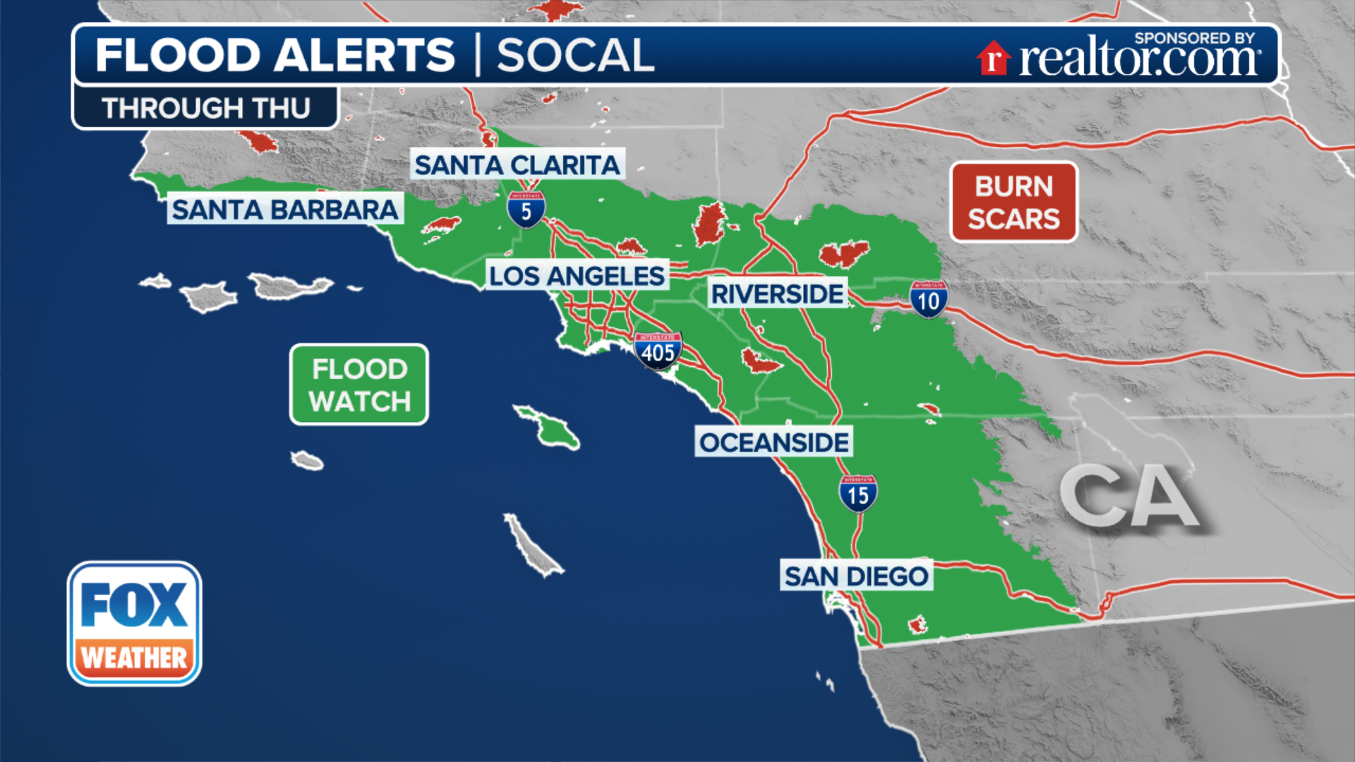
Relentless rounds of rain will move through the West this week bringing widespread rain throughout the week with up to a foot of rain in isolated areas. Flood alerts are in place for more than 5 million in California through Wednesday.
SAN FRANCISCO – A series of three atmospheric river storms are soaking Northern California this weekend and into the week ahead in the form of valley rain and mountain snow, with the potential for significant impacts around the San Francisco Bay Area.
Computer forecast models show much of the moisture from the first storm will repeatedly soak the Bay Area and points northward this weekend, producing widespread rain totals of 1-3 inches, with 5-6 inches possible in the higher elevations.

(FOX Weather)
Flood Watches are in effect for more than 12 million people, including the San Francisco Bay Area and Sacramento, through Sunday evening.
"Notice all the active flood alerts that we have in effect through today," FOX Weather Meteorologist Kendall Smith said. "They encompass places like Redding, Chico, Sacramento, Stockton, San Francisco. So, a large majority of the I-5 and I-80 corridors are under a flood alert for some very heavy rain that is likely to fall below about 3,000 feet in elevation."
(FOX Weather)
Forecasters say because the air mass originates near Hawaii, which is commonly referred to as a "Pineapple Express," the overall event will be warmer, causing snowfall levels to rise to several thousand feet.
The National Weather Service’s Weather Prediction Center has highlighted a large area of Northern California with a Level 2 out of 4 flash flooding risk through Tuesday.
Some river levels across the region are already elevated, leading to a greater risk that waterways could overrun their banks.

(FOX Weather)
"Over the past three days, I mean, look at these totals, incredibly impressive, especially hovering right over the state line of California and Oregon," Smith continued. "Upwards of 5 to 8, even maybe 8 to 12 inches of rain has fallen over the past three days. That’s a lot of rain, and we aren’t done just yet."
With the rain comes the wind, especially along the coastal and mountain areas, where gusts will reach 30-40 mph through the weekend.
"The combination of gusty winds and moistening soils will increase the likelihood of downed trees and power outages this week," the National Weather Service office in San Francisco said.
Meanwhile, feet of snow – perhaps several feet – looks likely from the extreme northern Sierra Nevada into the Cascades, which would bring major travel impacts to Interstate 80 and even the higher elevations of Interstate 5.

(FOX Weather)
"This is going to be a lot of snow again. You guys know the drill if you live in this part of the country," FOX Weather Meteorologist Ari Sarsalari said. "The passes are going to become probably impassable at points. And yeah, we've already had a lot of snow up in the Sierra in Central and Northern California through this rainy season. And we're going to continue to see a lot more through this event."
More storms on the way in the week ahead
The current atmospheric river storm will continue to push inland on Sunday, only to be replaced by another storm from Monday into Tuesday, peppering the region with additional rainfall.
Another 1-2 inches of rain is expected in the Bay Area on Monday and Tuesday, with higher amounts in the North Bay. A third storm system will bring additional showers from Wednesday through Friday and fill the rain gauges even more.
By the end of the week, storm totals could reach 8-9 inches across the mountains, with 4-6 inches of rain in the Bay Area valleys.
"Shallow landslides will be possible in coastal areas of the North Bay," NWS San Francisco said. "The threat will extend southward to higher elevations of the Bay Area, particularly the Santa Cruz Mountains by Tuesday."
FIREFIGHTERS WATCHING FOR HOTSPOTS FROM CALIFORNIA’S DEADLY WILDFIRES
Limited relief for fire zone
While Northern California basks in heavy rainfall, residents in the southern part of the state will be hoping for some added moisture.
Since early January, parts of Los Angeles and San Diego counties have experienced large fires that have destroyed more than 16,000 structures and caused hundreds of thousands of people to temporarily leave their homes.
Nearly 54% of the state is officially in drought conditions, with extreme levels reported in some of the same fire zones.

(FOX Weather)
Since the storm track is not expected to be directly over Southern California, more modest chances of precipitation are expected over cities and communities such as Los Angeles and San Diego, where as much as three-quarters of an inch of rainfall is possible this week.
Potentially equally beneficial will be the higher humidity values, which are sure to help tamp down any major flareups along wildfires.
"Even if a spot like Los Angeles doesn’t see any kind of substantial rain, a little bit of moisture is exactly what you need," FOX Weather Meteorologist Hayley Meier said.