Multiday severe weather threat begins with millions bracing for damaging winds, possible tornadoes
The FOX Forecast Center said computer forecast models are highly confident that ingredients will come together to produce a widespread severe weather event kicking off late Monday and lasting into Wednesday.

Multiday potential severe weather outbreak kicks off Monday in Plains
Tens of millions are facing a severe weather threat through this week during a potential dangerous severe weather outbreak. FOX Weather Meteorologist Ian Oliver describes the timeline of the storms expected Monday night for parts of Kansas, Oklahoma and Texas and the tornado threat on Tuesday across the Southeast.
FOX Weather's continuous coverage of the multiday severe weather threat has moved to this link. Click here to follow live updates.
Tens of millions of people across the U.S. from the Plains to the Southeast are preparing for a potential multiday severe weather outbreak this week as forecasters warn of large hail, damaging wind gusts and even some strong tornadoes.
Strong thunderstorms rolled across Oklahoma and Texas on Sunday, but the FOX Forecast Center said the more significant severe weather threat began Monday night and is expected to last through at least Wednesday.

(FOX Weather)
The FOX Forecast Center said computer forecast models are highly confident that ingredients will come together to produce a widespread severe weather event Monday night into Tuesday morning.
This includes a strong area of low pressure developing in the Plains, which will then pull in warm and humid air from the Gulf. That will provide the atmospheric energy needed for storms to develop and strengthen.
In addition, forecasters are concerned that strong winds aloft moving over the air mass will provide ample wind shear – the change in wind speed and direction with height – to allow for those storms to rotate.

(FOX Weather)
According to NOAA’s Storm Prediction Center (SPC), a rapidly developing line of thunderstorms could produce severe hail, damaging wind gusts and maybe a tornado or two across portions of the southern Plains.
Forecasters say some supercell thunderstorms could develop before the storms combine into an organized line, and strong to severe thunderstorms could develop south-southeastward into and across the Interstate 35 corridor from south of the Wichita, Kansas, area, through Oklahoma City and into North Texas, including the Dallas-Fort Worth Metroplex.
The SPC highlighted areas of the central and southern Plains where the threat of severe weather is higher.
More than 3 million people in Texas and Oklahoma were placed in a Level 3 out of 5 risk of severe weather on the SPC’s 5-point severe thunderstorm risk scale. This includes cities such as Oklahoma City and Norman in Oklahoma and Wichita Falls, Denton and Lewisville in Texas.
DOWNLOAD THE FREE FOX WEATHER APP
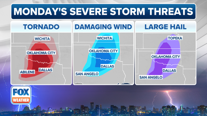
This graphic shows the tornado, damaging wind and large hail threat on Monday, March 3, 2025.
(FOX Weather)
The Dallas-Fort Worth Metroplex has not been placed in the Level 3 risk zone and remains in a Level 2 threat along with more than 8 million other people across the region.
Forecasters are concerned that many of the storms are expected to develop as we head through the evening and overnight hours and into early Tuesday morning.
NIGHTTIME TORNADOES: HOW YOU CAN STAY SAFE FROM NOCTURNAL TWISTERS
More than 41 million from southern Plains to Southeast face severe weather threat Tuesday

(FOX Weather)
As we head into Tuesday, the severe weather threat will explode in population and coverage, with the SPC placing more than 41 million people from eastern portions of Texas and Oklahoma into western Georgia and the Florida Panhandle at risk of severe weather.
However, more than 3.5 million people in southern Arkansas, northern and central Louisiana and central and southern Mississippi have been placed in a level 3 out of 5 risk on the SPC's 5-point severe thunderstorm risk scale.
Cities in the threat zone include Shreveport, Monroe and Bossier City in Louisiana, Pine Bluff in Arkansas and Jackson in Mississippi.

Watch: Threat of high winds forces Jefferson Parish to cancel Mardi Gras parades Tuesday
Jefferson Parish President Cynthia Lee Sheng held a news conference on Monday and said that Mardi Gras parades scheduled for Tuesday have been canceled due to the threat of high winds. Louisiana, including the New Orleans area, is at risk of seeing severe weather on Tuesday.
New Orleans is also at risk of severe weather on Tuesday, which has impacted some Mardi Gras celebrations across the region. Officials in Jefferson Parish held a news conference on Monday to announce parades there were canceled because of the threat of high winds.
"So I’m just going to cut to the chase with the very disappointing news that I think you all have probably heard about already," Jefferson Parish President Cynthia Lee Sheng said at the news conference Monday. "We’ve been in communication with the National Weather Service, and tomorrow’s weather, especially the gusty winds, is severe enough that we have no other choice but other than to cancel our scheduled parades for tomorrow."
This includes the Krewe of Argus parade and the Elks Krewe of Jeffersonians, Sheng said.
![This graphic shows the tornado threat on Tuesday, March 4, 2025.]() Image 1 of 2
Image 1 of 2This graphic shows the tornado threat on Tuesday, March 4, 2025. ( )
![This graphic shows the damaging wind threat on Tuesday, March 4, 2025.]() Image 2 of 2
Image 2 of 2This graphic shows the damaging wind threat on Tuesday, March 4, 2025. ( )


"We want you to be prepared ahead of the storm system that is developing and intensifying as it's working its way across the West," FOX Weather Meteorologist Kendall Smith said. "And by the time it arrives tomorrow (Tuesday), it's going to have all of those severe weather ingredients in place that it needs for this to become a widespread, severe weather, and perhaps even a tornado outbreak."
The FOX Forecast Center said that while damaging wind gusts appear to be the main threat from storms that develop, tornadoes could also be a big concern.
Forecasters say some tornadoes could even be strong, EF-2 or higher on the Enhanced Fujita Scale.
More than 67 million from Florida to New York face severe weather threat Wednesday

(FOX Weather)
The severe weather threat will continue to barrel across the U.S. by Wednesday, putting more than 67 million people along the East Coast from the Southeast to the mid-Atlantic at risk of some powerful storms.
The FOX Forecast Center said the line of storms on Wednesday may reenergize with the heating of the day, and that has forecasters concerned about the renewed severe weather risk.
The SPC placed an area from southeastern Georgia to southeastern Pennsylvania in a level 2 out of 5 threat, including cities like Baltimore, Washington, Virginia Beach and Norfolk in Virginia, Wilmington and Raleigh in North Carolina, Myrtle Beach in South Carolina and Savannah in Georgia.