Central American Gyre triggers deadly flooding, landslides
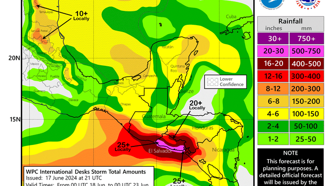
Since June 11, heavy rain has fallen over the region, where NOAA expected more than 20" of rain to fall. Central American Gyres can aid in the development of tropical cyclones in the Caribbean, the Gulf of Mexico and the eastern Pacific. The gyre is responsible for producing Potential Tropical Cyclone One, which has started to cause squally conditions in Mexico and Texas.

Tropical downpours, landslides kill at least a dozen across Central America
The Central American gyre has produced significant flooding for countries that boarder the eastern Pacific and western Caribbean.
SAN SALVADOR, El Salvador – Days of torrential downpours in Central America have triggered landslides and flooding, which have resulted in at least a dozen deaths, with the persistent Central American Gyre showing few signs of abating.
Authorities in El Salvador reported at least 11 people have been killed, while in neighboring Guatemala, at least three people were reported to have drowned.
A series of tropical disturbances in both the Pacific and Atlantic basins have produced torrential rainfall, and by the time the pattern subsides, precipitation totals are expected to reach several feet.
In addition to the fatalities, hundreds of rescue operations have taken place, and the government of El Salvador has issued a national emergency as heavy rainfall continues to trigger mudslides and landslides.
"We have deployed more than 30,000 soldiers dedicated to responding to emergencies, 19 work groups and machinery. In addition, the camps and shelters are supplied to deal with emergencies caused by the rains," Guatemalan President Bernardo Arévalo said before the heavy rainfall.
Photos and videos from the affected region showed dozens of landslides that have destroyed homes and blocked roadways.
NOAA precipitation forecast map
(FOX Weather)
WHAT IS A CENTRAL AMERICAN GYRE?
Nearly every hurricane season, the FOX Forecast Center monitors a broad area of low pressure in the western Caribbean Sea and eastern Pacific Ocean, known as a gyre.
During the early and latter parts of the hurricane season, the area is notorious for aiding in the development of tropical disturbances in the eastern Pacific, Bay of Campeche or western Caribbean Sea.
During the current gyre’s evolution, the National Hurricane Center has warned about the possibility of at least three different cyclones, with what is known as Potential Tropical Cyclone One, having the highest potential for development.
A PTC is a designation used by the National Hurricane Center to indicate a disturbance that is not yet a tropical cyclone but has the potential to develop into one over the next 48 hours and threaten land.
POTENTIAL TROPICAL CYCLONE 1 PROMPTS TROPICAL STORM WARNING ALONG TEXAS GULF COAST
PTC One is expected to produce heavy rainfall and gusty winds from Texas into Mexico during the next few days.
If the disturbance gains a low-level circulation, the FOX Forecast Center says sustained winds would meet the threshold for the NHC to declare the system a tropical storm.
The forecast for the Texas coastline and Mexico would not change, as both a PTC and a tropical storm deliver similar impacts.
If the disturbance were to gain a name, it would be known as Alberto and be the Atlantic basin’s first cyclone of the year.

(FOX Weather)