Saharan dust reaches stunning levels in Atlantic. Here's what that means for hurricane season
Significant Saharan dust plumes are common in the Atlantic during the start of hurricane season. If levels of SAL maintain a steadiness after about Aug. 20, then there would be significant ramifications to both the amount of cyclones and their overall strength.
What's next in the tropics after Beryl?
The Atlantic basin has turned eerily quiet, but that does not mean there aren't features to track in the tropics.
First, Europe that was socked in by record levels of dust from the Sahara Desert in Africa. The Atlantic appears to have now taken the lead, with dust levels not seen in years across parts of the basin.
Satellite measurements indicate intensive plumes of dust, called the Saharan Air Layer, across much of the eastern Atlantic. Traces of dust have even made the more than 4,000-mile journey to Florida and the Gulf Coast.
Sunrises and sunsets have been enhanced across the Sunshine State as the particles scatter typical colors, allowing hues of orange, yellow and red to dominate the sky.
Aside from the vibrant colors, something not falling from the sky is precipitation.
According to NOAA, the air surrounding the SAL has about 50% less moisture than the typical atmosphere. This means the presence of the SAL can be detrimental to cloud formation and thunderstorm activity.
Significant plumes of dust and dry air are common during the first months of the hurricane season and usually persist through mid-August.
A LOOK AT A PHENOMENON THAT COULD DERAIL AN ACTIVE HURRICANE SEASON

(FOX Weather)
How Saharan dust impacts hurricane season
NOAA estimates that more than 180 million tons of dust leave the African continent every year, reducing thunderstorm activity and tropical cyclone formation.
Dry air and Saharan dust are perennial wild cards in tropical weather outlooks, as meteorology has yet to develop sufficient methods to forecast plumes weeks and months in advance.
Years with significant dust often experience reduced cyclone activity. Seasons with minimal dust typically rank at the top echelons of activity, thanks to increased moisture availability for tropical systems and warmer water temperatures.

(FOX Weather)
The current season is a bit unusual as water temperatures started on the warm side across much of the basin, negating any minor effects from a dust storm.
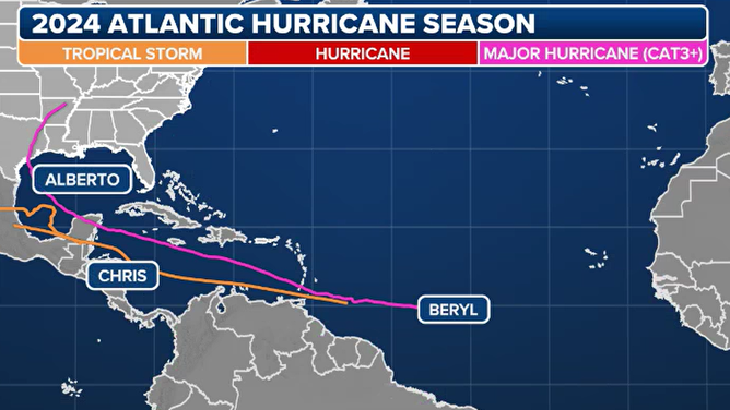
Warm waters and limited exposure to dry air helped with the formations of Alberto, Beryl and Chris during late June and early July.
Since Beryl’s historic trek through the Caribbean and into the Gulf of Mexico, the basin has been relatively quiet, a likely product of the increase in dry air.
The trend for limited activity in the Atlantic basin is expected to continue for the foreseeable future, meaning that the next cyclone formation may be weeks away.

Atlantic hurricane season 2024 summary as of July 13, 2024.
(FOX Weather)
5 THINGS TO KNOW ABOUT THE SAHARAN DUST PLUME
During an average year, the fourth-named storm usually doesn’t form until about Aug. 15, meaning any formation during the next month will keep the season ahead of a typical schedule.
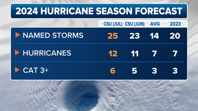
Despite the hostile conditions in the Atlantic, hurricane forecasters at Colorado State University maintain that 2024 will be a busy season in the Atlantic.

2024 updated Colorado State University hurricane season forecast.
(FOX Weather)
CSU released its updated outlook Tuesday, which calls for an additional 22 named storms, 11 hurricanes and five major hurricanes.
"This forecast is of above-normal confidence. We anticipate a well above-average probability for major hurricane landfalls along the continental United States coastline and in the Caribbean," CSU forecasters stated during their most recent tropical update. "As with all hurricane seasons, coastal residents are reminded that it only takes one hurricane making landfall to make it an active season."
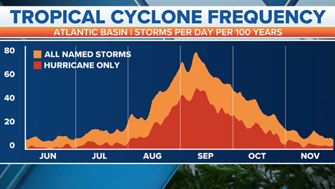
The season runs through Nov. 30, but nearly 60% of cyclone formation occurs in August and September.

Tropical cyclone frequency chart from June 1 to Nov. 30.
(FOX Weather)
