Triple threat of severe storms, extreme flooding and snow threatens wide swath of US
Moderate-to-heavy snow will primarily target the Interstate 90 corridor from Des Moines, Iowa, to Chicago and eastward into New England this weekend. Meanwhile, dangerous severe storms are likely to erupt across the South and Southeast on Saturday.

Tornado Watch issued for Lower Mississippi Valley on Saturday
Just shy of 4 million people were put under a Tornado Watch on Saturday which included the towns of Memphis, Greenville and Shreveport.
Fast Facts
- Extreme ‘High Risk’ Of Flooding across parts of Tennessee and Ohio Valley
- Flood Watches have been issued that extend over 900 miles from Arkansas to Pennsylvania.
- Accumulating snow is expected in at least 20 states east of the Rockies over the weekend.
- Strong wind gusts between 40-65 mph are likely across the Southeast on Saturday, then spread into the Northeast on Sunday and continue into Monday.
A powerful storm system will bring a mix of snow, rain and severe weather to the central and eastern U.S. this weekend, impacting a wide swath of the country.
Dangerous storms are likely to erupt across the Southeast throughout Saturday night into Sunday from East Texas into much of the Southeast and parts of the mid-South. Scattered to numerous damaging wind gusts and a few tornadoes are the primary threats.

(FOX Weather)
A Level 3 out of 5 severe storm risk has been issued by the National Weather Service's Storm Prediction Center, affecting nearly 6 million people in cities including Memphis, Tennessee; Shreveport and Bossier City in Louisiana; Jackson, Mississippi; and Tuscaloosa, Alabama.
Supercell thunderstorms are expected to develop along a corridor from northern Louisiana into western Tennessee Saturday afternoon into the early evening, with damaging winds and tornadoes expected.
"Additionally, given the strength of the wind fields, and very dynamic, fast-moving trough (of low pressure), there is a risk for strong tornadoes," The National Weather Service's Storm Prediction Center said in issuing the level 3 severe threat alert."
"Some spots, if you live farther toward the west, some of these storms will fire up earlier on a day like mid-day into the early afternoon," Sarsalari said. "But for a lot of this area… Jackson, Mississippi, Birmingham; this is going to be evening into the overnight."
Dangerous to ‘extreme’ flash flooding takes shape Saturday
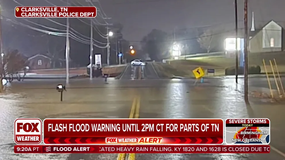
Life-threatening flooding pummels Tennessee, Kentucky
Water rescues have been reported in western Tennessee and southern Kentucky as more than 3-5 inches of rain fell by Saturday afternoon with more on the way.
On Saturday into Saturday night, widespread and repeated rounds of heavy rainfall are expected in the Southeast into the Ohio Valley.
LIFE-THREATENING FLASH FLOODING LOOMS AS TORRENTIAL RAINS SOAK TENNESSEE, KENTUCKY
Rainfall amounts of 3-5 inches or higher are possible, particularly across portions of Tennessee, Kentucky, southern Ohio, southern West Virginia and western Virginia.
NOAA's Weather Prediction Center has now issued their most dire level 4 flash flood threat rating of "extreme" to parts of northwestern Tennessee and southwestern Kentucky.

(FOX Weather)
"There's so much moisture available and it's going to continue to get pumped in from the south throughout the day," Sarsalari said. "This is the real problem here – 1 to 2 inch per hour rain rates. That's a that's an extreme rate of rain. So it's going to be falling so heavily, the creeks and streams start to get overloaded. And then all of a sudden, before you know it, you've got catastrophic flooding going on, which is definitely a possibility today."
WHY RARE 'HIGH RISK' FLOOD DAYS NEED TO BE TAKEN SERIOUSLY
High risks are only issued on about 4% of days, but this risk category accounts for 39% of flood-related fatalities and 83% of flood-related damages in the continental U.S., according to research by WPC meteorologists. About half of such alerts result in at least one death.
"So this is going to be a really big deal," Sarsalari said.
A Level 3 out of 4 risk for flash flooding expands farther out into the Ohio and Tennessee Valleys as potential exists for numerous flash floods, some of which could be significant.
Flood Watches have been issued that extend over 900 miles from Arkansas to Pennsylvania. About 11 states are included under these.
DOWNLOAD THE FREE FOX WEATHER APP
In addition, moderate to isolated major river flooding is possible this weekend across portions of central and eastern Kentucky, southwest Virginia and northern and central Tennessee as regional watersheds respond to the copious amount of rain and resulting runoff.
More snow to fall across Midwest, New England

70 million under winter storm alerts as heavy snows, strong winds threaten Great Lakes, Northeast
Another round of heavy snow and gusty winds are set for the Great Lakes and inland Northeast over the weekend.
The storm is also expected to bring accumulating snow to at least 20 states east of the Rockies over the weekend.

(FOX Weather)
The FOX Forecast Center said this weekend's snowstorm is the same system that brought significant rain and mountain snow to California on Thursday. The storm is now crossing the country and is expected to rapidly strengthen as it moves through the Northeast and into Canada. As a result, the most significant impacts from the storm will be across the interior Northeast and back toward Michigan.

(FOX Weather)
After crossing the Rockies on Friday, the storm is expected to quickly gather moisture from the Gulf and the Atlantic as it moves along. Snow will start on Friday in parts of the northern and central Plains, spreading eastward across the Upper Midwest on Friday night and Saturday, and reaching the Northeast from Saturday to Saturday night.
Winter weather alerts are already up for parts of the Upper Midwest and Northeast. A broad area is forecast to receive at least 3 inches of snow. Cities likely to see enough snow to require shoveling and plowing include Minneapolis; Des Moines, Iowa; Chicago; Detroit; Cleveland; Buffalo and Albany, New York; Burlington, Vermont; Boston and Worcester, Massachusetts; Manchester, New Hampshire; and Portland and Augusta, Maine.
Snow will also accumulate along Interstate 70 in the Midwest and parts of western Pennsylvania, as well as along much of I-80 in Pennsylvania and New Jersey.

(FOX Weather)
In the Northeast, the most significant snowfall is expected across central New York and central New England, where over a foot of snow is likely.
A wintry mix, forecast to change to rain at the storm's peak, will extend along and south of I-84 and 86 in New York and the Connecticut and Massachusetts Turnpikes in New England. Philadelphia, Baltimore, and Washington, D.C., are expected to see mostly rain.
Strong winds, gusting between 40-65 mph, are expected to develop across the Southeast on Saturday, then spread into the Northeast on Sunday and continue into Monday. These prolonged strong winds could cause significant damage, including downed trees and power outages.