Two more atmospheric rivers take aim at California, Northwest bringing flood threat
Two atmospheric rivers make their way into the Pacific Northwest before a third, stronger storm, signals the change in weather patterns and puts California at risk of flooding, dangerous surf and heavy snow.
Potent atmospheric river threatens California, West Coast with flooding rain, high winds, mountain snow
A potent atmospheric river will threaten California and much of the West Coast by midweek with flooding rain, high winds and mountain snow. NOAA's Weather Prediction Center has already issued a Level 2 out of 4 flash flooding risk for Wednesday in Northern California, with a Level 1 out of 4 risk posted for Thursday in Southern California.
A rainy start to the weekend in the Pacific Northwest is just the latest chapter in what will be a very soggy week across much of the West Coast as a pair of increasingly stronger atmospheric river storms aims for the Pacific Coast, with greater impacts possible for California.
A first atmospheric river storm brought moderate rain to Washington and Oregon Friday through Saturday. While no major impacts were expected, a second and especially third atmospheric river storm next week are packing a stronger punch, with the midweek storm threatening California with some flooding, heavy rain, heavy mountain snow and high winds.
SAN DIEGO FLOODWATERS PROMPT DRAMATIC RESCUES AS REGION SEES RECORD RAIN

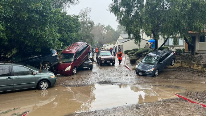
Aftermath of flooding in San Diego on Monday.
(San Diego Fire Dept. / FOX Weather)
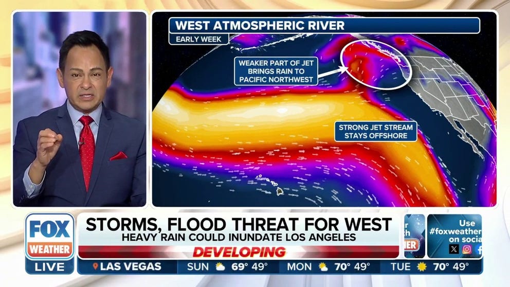
"You have a big pattern change out West," said FOX Weather Meteorologist Amy Freeze. "We talk about the atmospheric river that's taking aim on the West Coast. Pay attention to this one. It's said to blast the Golden State in a week… This has got all the hallmarks of a high-end flooding situation for California, some beach erosion, mudslides, potentially, and a lot of mountain snow."
CALIFORNIA'S ‘ARKSTORM’: HISTORIC 1000-YEAR FLOODS OF 1861-62 FEATURED 8 WEEKS OF ATMOSPHERIC RIVERS
Northwest takes the brunt of the storms first
Steady rains were in the cards for much of Saturday in the Pacific Northwest as this first atmospheric river storm continued to soak the region. Rainfall totals were expected to reach 2-3 inches in the mountains and up to about 1.50 inches in the lowlands, including the Seattle and Portland areas. For Seattle, Saturday will be the 12th consecutive day with measurable rainfall.
The storm track was expected to lift to the north late Sunday into Monday as a second, stronger atmospheric river storm moves in. This one will focus much of its power on Vancouver Island and southwestern British Columbia, triggering heavy rain and flooding worries there, though northwestern Washington will get a glancing blow for more rain.

(FOX Weather)
Meanwhile, warm, tropical-infused air will flood the Northwest on the southern side of the atmospheric river storm, with highs in Seattle expected to reach 60 degrees on Monday, which would be the first time in four years the city has reached that mark in January and just the 10th time in the past two decades.
"Just to say the word ‘Pineapple Express’ — where that moisture source is – is even south of Hawaii," said FOX Weather Meteorologist Stephen Morgan. "So you’re in the tropical Pacific and tapping into some of that moisture — that’s why you get the warmer temperatures.
Northern California at risk for flooding starting Wednesday
Rain will sag back south into the Pacific Northwest on early Tuesday as that second storm gets in its last punch, but a third atmospheric river storm rolls in hours later, and this one looks the strongest and has the greatest potential for impacts.
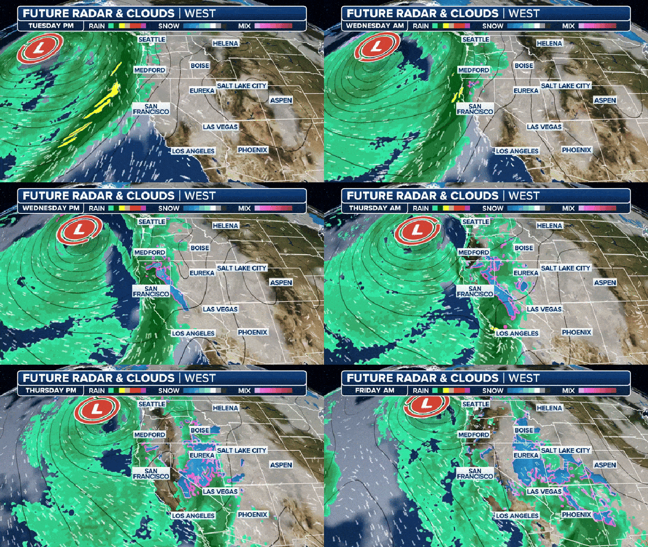
That storm will again begin in the Pacific Northwest on Tuesday and then journey south along the Pacific Coast into California on Wednesday. According to the FOX Forecast Center, the impactful event could lead to flash flooding and beach erosion.
WHY CALIFORNIA IS PRIMED FOR LANDSLIDES

Futuretrack of the third and strongest atmospheric river. This is the start of wild weather for California.
(FOX Weather)
NOAA's Weather Prediction Center has placed much of the Northern California coastline under a Level 2 out of 4 risk for flash flooding on Wednesday.
"The jet extension here has shown itself, and that means that the coastline is going to be inundated with rain, and there's flood danger with that," Freeze said. "The El Niño just exaggerates that... And if you've got, atmospheric rivers rolling in from the jet extension and then that sudden push from El Niño, you've got a very active week ahead."
Heavy rains and gusty winds will sweep through California from north to south during the day Wednesday, though as long as the storm keeps moving, the state may avoid major impacts.
"As long as that thing is driving, our storm is on a non-stop journey," wrote NWS forecasters in San Francisco. "That's certainly not to say this storm won't be impactful."

(FOX Weather)
STRONG EL NINO WINTER: WHAT KIND OF WEATHER YOU CAN EXPECT
With soils near saturation from previous storms, rain will easily run into creeks and rivers.
"The good news is that our main stem rivers are doing well and can accept quite a bit of runoff before becoming problematic," NWS San Francisco wrote. "At this point, there is a low chance (~10%) of any main stem river going into flood stage."

(FOX Weather)
However, localized stream and urban flooding, shallow land and mudslides and tree falls from gusty winds are likely impacts. And those winds could lead to power outages. Meanwhile, persistent high waves put the coast at risk for coastal erosion and flooding, similar to the surf that crashed into much of California in late December and early January. And the higher elevation areas of the Sierra Nevada could see feet of snow.
WATCH: MAMMOTH WAVE NEAR LOS ANGELES SMASHES INTO BEACH SPECTATORS
Southern California gets wet on Thursday
The storm will continue pushing south into Southern California on Thursday for a very rainy day around Los Angeles and San Diego.
But so far, rainfall totals look like flooding impacts will be limited, with about 1-2 inches in the lowlands and 2-4 inches in the surrounding mountains and foothills.

(FOX Weather)
"Rain of this type typically brings moderate flooding that mostly stays confined to the roads," wrote forecasters with NWS Los Angeles on Saturday morning. Even if some of the heavier rainfall total forecasts pan out, "roads will still be the focus of the flooding but amplified in severity, with some isolated creek and neighborhood flooding added in."
Gusty winds will buffet Southern California with the frontal passage Thursday, with the possibility of tree damage and power outages.
Long-range forecasts indicate a rainy pattern continuing across California through the end of next week and the following week.
