Severe storms kick into high gear Thursday with tornadoes, damaging winds and hail through Sunday
Multiple disturbances will emerge from the Rockies and bring dangerous rounds of severe storms to the Plains and Mississippi Valley. This is typical, as severe weather often peaks in these areas from late April through May.
Multi-day severe weather event expected to impact to impact Plains, Midwest
The first round of severe weather will kick off on Thursday with threats for large hail, damaging winds and tornadoes.
A severe weather threat looming for the next several days could be dangerous and possibly life-threatening. Despite a lack of tornado activity so far this year, Tornado Alley is expected to have a significant increase in activity.
Multiple disturbances will emerge from the Rockies and bring dangerous rounds of severe storms to the Plains and Mississippi Valley. This is typical, as severe weather often peaks in these areas from late April through May.

(FOX Weather)
Strong tornadoes possible Thursday in Kansas, Oklahoma and Texas
The main event will begin as a dip in the jet stream approaches the central U.S. Concurrently, an area of low pressure will form at the surface, and showers and thunderstorms will develop later in the day.
Much of the day might remain tranquil while an atmospheric lid, known as a "cap," keeps storms at bay. However, this will change in the early evening when storms are expected to break through the "cap," and a few intense supercells could form near the dryline from western Kansas into western Oklahoma and the Texas and Oklahoma panhandles.
"Storms are going to really pop up on Thursday, Thursday night and continue to roll right through these central Plains states all across the Upper Midwest through the morning on Friday," FOX Weather Meteorologist Bob Van Dillen said. "Then behind that, we've got more storms that are going to fire up with another cold front as it drives through."
NOAA's Storm Prediction Center has issued a Level 3 out of 5 risk due to an increased potential for EF-2 or stronger tornadoes.

(FOX Weather)
Hail larger than baseballs is likely to be the primary initial hazard, the FOX Forecast Center said. A notable increase in low-level wind shear – the change in wind speed and/or direction with height – after 7 p.m. CDT will also support a tornado threat with any supercells that can persist into the evening in parts of western Kansas and Oklahoma.
Although any initial dryline storms may diminish by mid- to late evening, renewed storm development could occur overnight as a cold front overtakes the dryline from southwestern Texas into western and central Kansas and Oklahoma. Severe wind gusts may become an increasing threat with nighttime storms, though hail and a couple of tornadoes will also be possible.
Broader area faces severe weather risk Friday
The tornado and damaging wind risk are expected to be even higher on Friday when the area of low pressure driving the multiday severe weather threat is forecast to reach its peak strength, broadening the risk of damaging storms and tornadoes to more states from Texas to Illinois.

(FOX Weather)
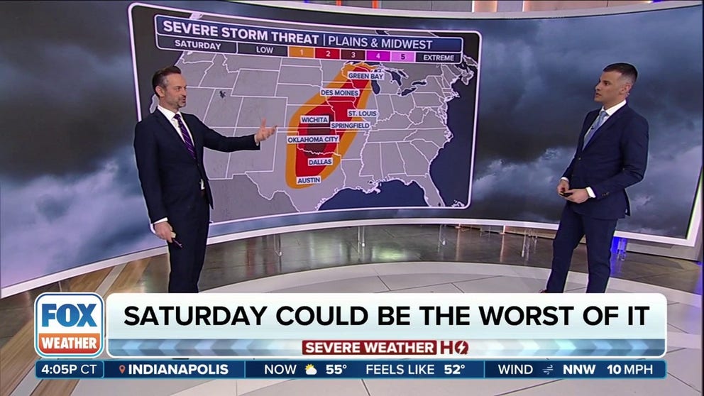
Weekend storm system brings renewed severe threat
The threat of severe thunderstorms in the nation's heartland will continue beyond the workweek.
As the Thursday-Friday storm system moves away, another one is forecast to emerge from the West and move into the Plains by Saturday.
"This is what we're concerned with when it comes to tornado threat. It's right there (below) in the Red River Valley, right through Oklahoma City and into the lower parts of Kansas," Van Dillen said. "This has been upgraded. This is day four. This is Saturday, we're looking at a Level 3 threat out of 5, which could get upgraded."

(FOX Weather)
As the system continues moving eastward, the risk of severe thunderstorms on Sunday will stretch from the Ark-La-Tex region to parts of the Midwest.
This weekend's storm system may pose a more significant risk of severe thunderstorms and tornadoes than the Thursday-Friday system. Be sure to download the free FOX Weather app and enable notifications to receive important weather alerts and monitor changes to the forecast.

(FOX Weather)
Even beyond these rounds of severe weather, the pattern will likely remain conducive for intense storms as the calendar turns to May next week.
