Severe weather threat covers 65 million Saturday ahead of more daunting storm forecast for Easter Sunday
Saturday will see the severe storm threat area shift only a bit as the cold front slowly sinks to the south and east. The storm threat contracts geographically, but ramps up in intensity on Easter Sunday as a powerful upper-level storm system moves from the Texas Panhandle into the Midwest during the day.

Easter Sunday weather forecast
FOX Weather meteorologist Nick Kosir is tracking who will see the threat of storms on April 20, 2025.
DALLAS - A multi-day severe weather pattern that already produced tornadoes and blistering hail to the Mississippi Valley over the past few days continues to threaten tens of millions into Easter, with perhaps the most dangerous day of thunderstorms still yet to come on Sunday.
On Saturday morning, a tornado-warned left a trail of damage in Springdale, with power lines knocked askew, some damaged cars, and metal streetlights bent in half.

(FOX Weather)
Farther north, a severe thunderstorm blew through Indianapolis with a peak gust of 84 mph, leaving over 20,000 in the dark, according to FindEnergy.com. Interstate 69 was closed near Pendleton, Indiana due to downed power lines on the roadway, while trees were knocked into a home in Muncie and onto cars in Putnamville, according to the National Weather Service.
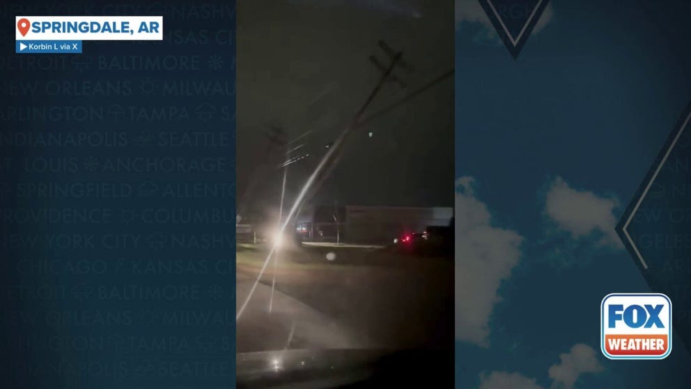
Watch: Multiple powerlines damaged in Arkansas during severe weather
Video shows multiple powerlines bent over after a tornado-warned storm in Springdale, Arkansas.
Storms will reenergize Saturday afternoon and evening across parts of the Lower Mississippi Valley and into the Southern Plains. NOAA's Storm Prediction Center has upgraded parts of central Texas to a Level 3 out of 5 severe weather threat - primarily for large hail threat. The SPC has also expanded the Level 2 threat that covers nearly 13 million, stretching from the heart of Texas, including the Dallas-Fort Worth Metroplex -- into eastern Oklahoma and southern Missouri and now into the Ohio Valley up through Cincinnati.
Due to the threat, a Severe Thunderstorm Watch was issued for several counties in the Lone Star State due to the threats of damaging winds and hail.

(FOX Weather)
Strong thunderstorm potential extends up into the Ohio Valley and even into the Northeast, but those areas remain just under a level 1 threat of severe thunderstorms. All told, over 65 million people are under the threat of severe thunderstorms on Saturday.
Severe weather dangers increase for Easter Sunday
The storm threat contracts geographically, but ramps up in intensity on Easter Sunday as a powerful upper-level storm system moves from the Texas Panhandle into the Midwest during the day.
"This is our biggest risk for severe storms that we've had in this stretch so far," says FOX Weather Meteorologist Jane Minar.
A rapidly strengthening low pressure center tracking from eastern Oklahoma into Iowa, will carry a potent warm front that will pull in more humid air, adding fuel for severe storms. Daytime heating will further destabilize the atmosphere, allowing thunderstorms to quickly intensify.
"As (the system) starts to eject into the Plains, that negative tilt often throws this corridor of really strong wind in the mid-levels of the atmosphere," Minar said. "That's going to help get some twisting on the board. Warm front lifting up through the region also provides an environment, that warm sector, for possible tornadoes."

(FOX Weather)
A Level 3 out of 5 risk of severe weather covers much of Missouri, including Springfield and Columbia, stretching south into northern Arkansas, including Little Rock. St. Louis sits just outside that risk zone in a Level 2 threat. About 20 million people are inside Sunday's severe weather threat zone.
Storms may begin developing late in the morning across eastern Kansas and Oklahoma, with a more organized line of severe storms expected across western Missouri and northwest Arkansas by the afternoon, according to the FOX Forecast Center. All risks of severe weather -- tornadoes, large hail and damaging wind gusts -- are on the table.
As the system races northeast, storms will continue moving rapidly into parts of Illinois and possibly southern Iowa. While there’s still some uncertainty about how much instability will be in place, conditions are aligning for potentially significant severe weather.
The severe weather threat wanes overnight Sunday with just general scattered thunderstorms forecast for Monday as the front treks east.