Tornadoes spotted as heartland pummeled again with severe weather after deadly storms
Communities east of Dallas and south St. Louis, Missouri, appeared to be the hardest hit with numerous tornadoes and water rescues.

Weekend severe weather outlook
Thunderstorms are expected to rumble across the Gulf Coast and the Tennessee Valley over the weekend.
LITTLE ROCK, Ark. – The nation's heartland was once again threatened by damaging thunderstorms and flash flooding on Friday, which triggered dozens of Tornado Warnings and at least two Flash Flood Emergencies to start the weekend.
Communities east of Dallas and south St. Louis, Missouri, appeared to be the hardest hit, with numerous tornadoes reported and water rescues.
More than 55 million residents were threatened by severe thunderstorms, and this did not include the impacts of additional rainfall on already saturated grounds.
WHY IS THIS RELENTLESS SEVERE WEATHER PATTERN STUCK OVER THE EASTERN HALF OF THE US?
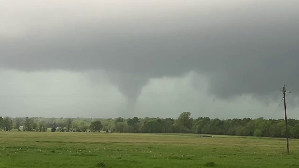
On Friday afternoon, one of the first supercells formed over the Red River Valley.
Significant damage to structures was reported around Clarksville, Texas, but there were no immediate reports of injuries.
Tornado tears through North Texas
On Friday afternoon, one of the first supercells to form happened over the Lone Star State, before the tornado moved into Oklahoma. Significant damage to structures was reported around Clarksville, Texas, but there were no immediate reports of injuries.
Further east, another significant supercell produced a tornado near Hawkins, Texas, which impacted homes and a bottling plant, according to National Weather Service storm reports.
As chance would have it, it was the second time the Hawkins-area facility was impacted by a twister during the last decade.
Fortunately, significant injuries were not reported.
TORNADO IMPACTS TEXAS BOTTLING PLANT FOR SECOND TIME IN LESS THAN A DECADE
Additional tornadoes were reported in Arkansas and Missouri, before the thunderstorm activity moved east of the Mississippi River.
The rounds of thunderstorms are courtesy of a stalled weather pattern — the same one that has produced significant and deadly severe weather for the Mississippi and Ohio valleys during the workweek.
Friday's round of severe weather was not as widespread as Wednesday's event, which produced more than 600 reports of wind, hail and tornadoes, but because thunderstorms are training over some of the same areas, the flood risk continues to increase.
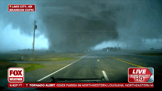
![Large and dangerous tornado crosses road right in front of FOX Weather Exclusive Storm Tracker Brandon Copic.]() Image 1 of 13
Image 1 of 13Large and dangerous tornado crosses road right in front of FOX Weather Exclusive Storm Tracker Brandon Copic. ( )
![FOX Weather exclusive footage shows the extensive damage caused by a tornado in Arkansas.]() Image 2 of 13
Image 2 of 13FOX Weather exclusive footage shows the extensive damage caused by a tornado in Arkansas. (Robert Ray)
![]() Image 3 of 13
Image 3 of 13Structural damage is visible at Christ Community Church after a tornado struck on April 3, 2025, in Paducah, Kentucky. ( )
![]() Image 4 of 13
Image 4 of 13Structural damage is visible at Christ Community Church after a tornado struck on April 3, 2025, in Paducah, Kentucky. ( )
![]() Image 5 of 13
Image 5 of 13Parishioners and community members look over damage after a tornado struck the Christ Community Church on April 3, 2025 in Paducah, Kentucky. ( )
![Three members from the Maplewood Fire Department were activated as part of the St. Louis County Urban Search and Rescue Team to respond to Delta Missouri just south of Cape Girardeau.]() Image 6 of 13
Image 6 of 13Three members from the Maplewood Fire Department were activated as part of the St. Louis County Urban Search and Rescue Team to respond to Delta Missouri just south of Cape Girardeau. (Maplewood MO Fire Department / Facebook )
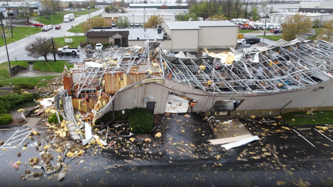
![Extensive damage seen on drone video at a Louisville, Kentucky business on April 3, 2025.]() Image 7 of 13
Image 7 of 13Extensive damage seen on drone video at a Louisville, Kentucky business on April 3, 2025. (Live Storms Media )
![Tornado damage in Monette, Arkansas on April 3, 2025 after a severe weather outbreak.]() Image 8 of 13
Image 8 of 13Tornado damage in Monette, Arkansas on April 3, 2025 after a severe weather outbreak. ( )
![Tornado damage in Monette, Arkansas on April 3, 2025 after a severe weather outbreak.]() Image 9 of 13
Image 9 of 13Tornado damage in Monette, Arkansas on April 3, 2025 after a severe weather outbreak. ( )
![Tornado damage in Monette, Arkansas on April 3, 2025 after a severe weather outbreak.]() Image 10 of 13
Image 10 of 13Tornado damage in Monette, Arkansas on April 3, 2025 after a severe weather outbreak. ( )
![Storm damage in Carmel, Indiana on April 3, 2025.]() Image 11 of 13
Image 11 of 13Storm damage in Carmel, Indiana on April 3, 2025. ( )
![Extensive damage seen on drone video at a Louisville, Kentucky business on April 3, 2025.]() Image 12 of 13
Image 12 of 13Extensive damage seen on drone video at a Louisville, Kentucky business on April 3, 2025. (Live Storms Media )
![]() Image 13 of 13
Image 13 of 13Downed trees and heavy structure damage are seen after tornadoes moved through the area on April 03, 2025 in Selmer, Tennessee. ( )


Life-threatening flooding impacts region
The repeated storms along the slow-moving front caused deadly flash flooding from Arkansas and Missouri through the southern Ohio Valley.
Forecast models show by the time the rainfall is over, an additional 3-5" could fall across much of the region, with some areas receiving substantially more.
Rainfall totals have already surpassed a foot in some communities, so any additional rainfall will only aggravate already high rivers and streams.
WHY HIGH-RISK FLOOD DAYS ARE SO SERIOUS
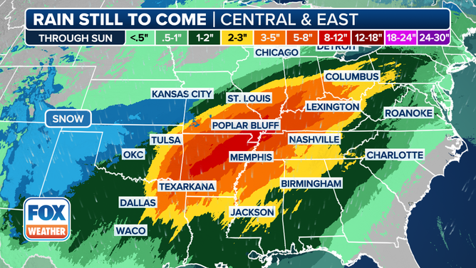
A look at the rainfall still to come through Sunday.
(FOX Weather)
Ridges of high pressure along the Eastern Seaboard have kept the weather pattern in place but are slowly eroding, which will eventually allow the rainfall to impact areas that have not seen much precipitation.
This shift will allow drier, less humid air to move in and end the wet and muggy weather that has plagued the region.
While the prospect of drier weather is welcome news, the floodwaters will not recede quickly. River levels will remain high for the foreseeable future, and if a wet weather pattern returns, any additional rainfall could be problematic.

How Lake City, Arkansas is racing against the clock to clean up
FOX Weather's Robert Ray is in Northeast Arkansas, which was recently impacted by an EF3 tornado.