Flash Flood Emergency issued in Alabama as tornadoes leave path of destruction in Mississippi
The NWS estimated over a foot of rain fell in areas in just six hours in Alabama on Monday while five tornadoes were seen over the course of 24 hours in Mississippi.
Possible tornado traps several in Mississippi bank
A possible tornado tore through Moss Point, Mississippi Monday. The Jackson County Sheriff told FOX Weather that so far the town suffered damage but no one injuries were reported. A group of residents was rescued after being trapped in a bank.
Severe thunderstorms continued to pound the South on Monday after an EF-3 tornado turned deadly near Louin, Mississippi, Sunday night.
Extensive damage was reported in Louin, and videos from the area after the tornado touched down around 11:40 p.m. CDT show buildings that were destroyed, trees snapped like toothpicks and vehicles obliterated by the storm’s ferocious winds.
Officials at the National Weather Service office in Jackson, Mississippi, confirmed that at least five tornadoes touched down late Sunday into Monday. Survey teams are assessing the damage in Smith and Jasper counties, where they found damage consistent with an EF-3 twister in Louin.
Drone video: First glimpse of deadly Mississippi suspected tornado damage
At first light, storm chaser Brandon Clement got a view of devastated areas of Louin, Mississippi, after a deadly suspected tornado hit Sunday night.
WE'VE ENTERED AMERICA'S MOST ACTIVE TIME OF YEAR FOR DAMAGING WINDS FROM SEVERE STORMS
A tornado appeared to touch down in Walton County, Florida, where a large funnel was captured on video near Sandestin late Monday morning.
Walton County Emergency Management said in a tweet Monday afternoon that it was assessing the damage and would share further information once the assessments were completed.

A tornado appeared to touch down near Sandestin, Florida, late Monday morning, June 19, 2023.
(Shere Smyly Callaway / Facebook)
Monday afternoon, a tornado in Moss Point, Mississippi, downed trees and power lines. Drivers reported that most side roads near and around downtown were blocked. Video shows damaged buildings and debris spread across a neighborhood.
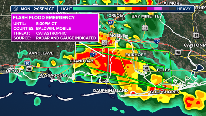
The NWS also issued a Flash Flood Emergency for Baldwin and Mobile Counties in Alabama. The NWS estimates over a foot of rain fell in areas in just six hours.

Flash Flood Emergency.
(FOX Weather)
Ankle-deep water flowed through a home under construction in Fairhope, Alabama.
Power outages linger in South after weekend storms
Almost 200,000 remained without power in Oklahoma on Monday evening after severe weather swept through the region over the weekend. In Texas, almost 80,000 were still without power.
Over 70,000 homes and businesses were out of power across Mississippi, Alabama, Arkansas and Tennessee.
(FOX Weather)
More severe storms possible along northern Gulf Coast on Tuesday
Severe thunderstorms are possible along parts of the northern Gulf Coast on Tuesday. A few strong storms could also develop farther east across Florida and southern Georgia.
Damaging wind gusts are the primary threat with Tuesday's storms, but large hail and an isolated tornado can't be ruled out.
HERE'S WHERE TORNADOES ARE MOST LIKELY TO OCCUR IN EACH MONTH

(FOX Weather)
Heavy rain leads to growing flood concerns
The Southeast and parts of the Carolinas are bracing for multiple days of heavy rain this week, causing the flooding threat to grow even though the rain will be spread out over a span of about five days.
A cutoff area of low pressure will remain nearly stationary across the region for most of the week. This will provide the necessary trigger for showers and thunderstorms, which will combine with a stream of deep moisture from the Atlantic to produce heavy rainfall.
PEAK FLASH FLOOD SEASON IN U.S. BEGINS IN JUNE
Overall, between 3 and 5 inches of rain is expected for most of the region, but some locations could receive nearly 8 inches of rainfall by the end of the week.

(FOX Weather)

