34 million in Midwest cities like Chicago, Indianapolis brace for powerful storms this week
May is typically bustling with severe weather, including nearly 300 tornadoes on average for the month, after both March and April saw well above-average tornado reports.

Severe weather threat kicks off Wednesday with millions in Midwest, Ohio Valley bracing for storms
A multiday severe weather threat will kick off starting Wednesday in the central U.S. before expanding into the Midwest and Ohio Valley as the week continues. FOX Weather Meteorologists Ari Sarsalari and Marissa Torres break down the latest on Tuesday, May 13.
CHICAGO – Millions of people in the Midwest and Ohio Valley are likely to see increasing chances of severe weather this week after portions of the U.S. were rocked by weeks of deadly storms and flooding.
There’s been an eerie lull in severe weather over portions of the country recently, especially in the central U.S.
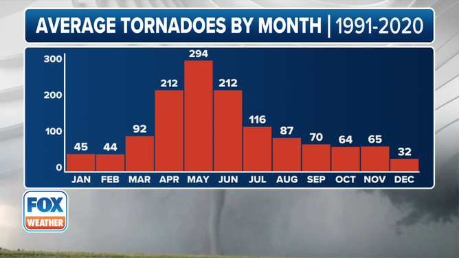
This graphic shows the average number of tornadoes by month between 1991-2020.
(FOX Weather)
It’s also unusual because May is typically bustling with severe weather, including nearly 300 tornadoes on average for the month, after both March and April saw well above-average tornado reports.
Changes are coming, however, to cities like Chicago, Detroit and Indianapolis in the coming days.
DOWNLOAD THE FREE FOX WEATHER APP

Watch: Video shows waterspout roaring ashore in Florida
A video recorded in Pensacola Beach, Florida, shows a waterspout moving onshore on Saturday, May 10, 2025.
The FOX Forecast Center said that an area of low pressure, part of an Omega block that dominated the weather headlines recently, has moved out of the area, allowing weather systems to once again move from west to east across the country.
As a result, an area of high pressure is forecast to move over the central U.S., allowing for some summerlike, potentially record-breaking heat to build from the U.S.-Mexico border in Texas to the U.S.-Canada border in the northern Plains and Upper Midwest.
SEE IT: LARGE WATERSPOUT SPOTTED ROARING ASHORE ALONG FLORIDA COAST

(FOX Weather)
The threat of severe weather will kick off on Wednesday, with portions of the central and northern Plains now under a Level 2 risk on NOAA's Storm Prediction Center’s (SPC) 5-point severe thunderstorm risk scale.
This threat zone includes cities such as Bismarck and Mandan in North Dakota, Aberdeen in South Dakota and Norfolk in Nebraska.
(FOX Weather)
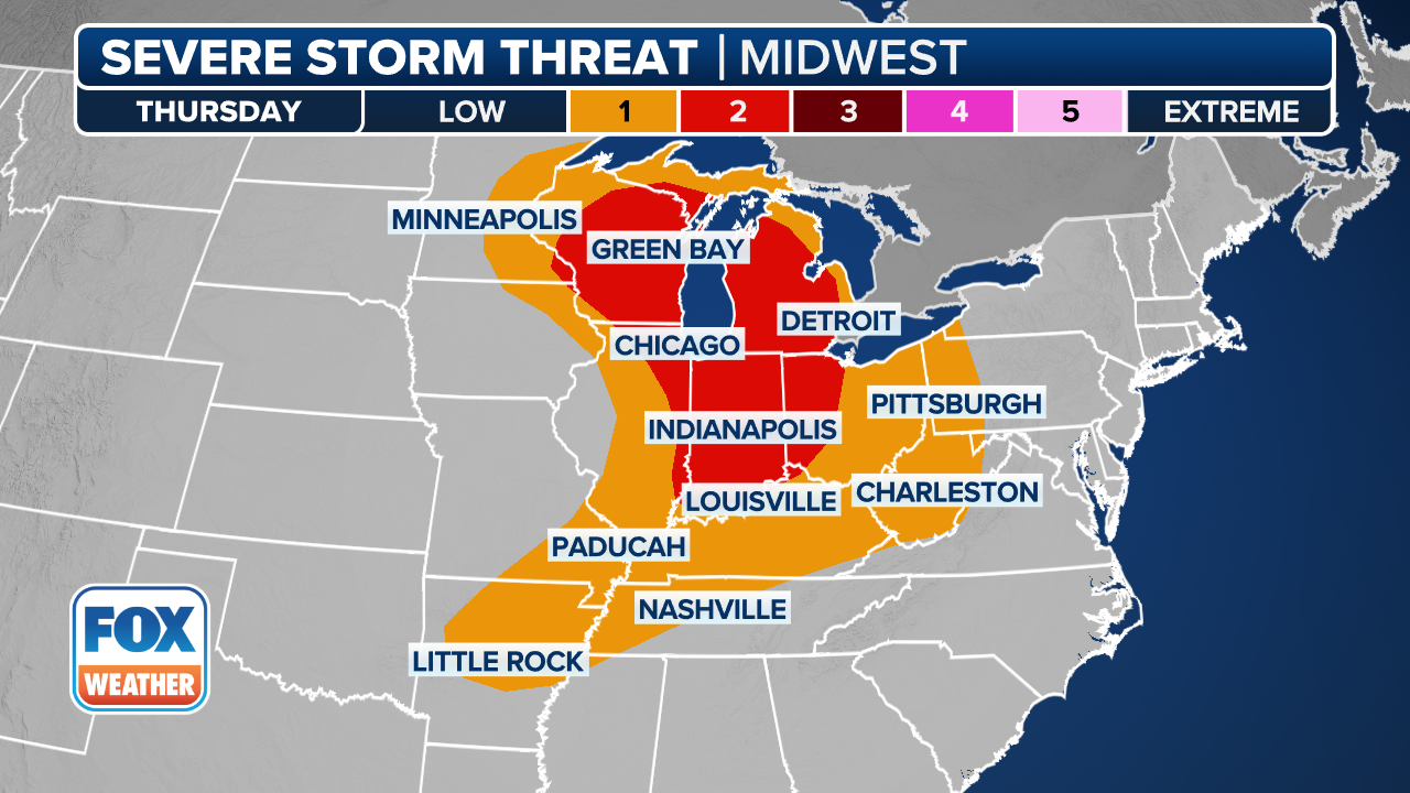
A higher threat comes into the picture on Thursday, with more than 34 million people from the Midwest to the Ohio Valley in a Level 2 out of 5 severe weather threat.
This includes cities like Chicago, Detroit, Indianapolis, Milwaukee and Toledo, Ohio.

(FOX Weather)
By Friday, the severe weather threat will continue in portions of the mid-Mississippi, lower Ohio and Tennessee valleys.
The SPC has so far placed more than 9 million people in a Level 2 out of 5 threat, including cities like Memphis and Nashville in Tennessee, Louisville and Lexington in Kentucky and Evansville in Indiana.