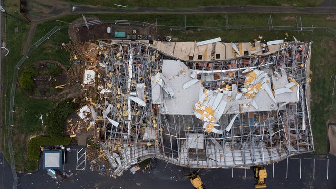
Southeast slammed with 13th day of powerful thunderstorms
This latest threat comes after at least 20 people were killed, including children and first responders, after a relentless barrage of tornadoes and historic flash flooding across several states.

Storms and flooding threat shifts east, set to move off coast
The storm threat that has left the US in its 13th straight day of severe weather is coming to an end. Storms should move off the Eastern seaboard by Tuesday morning.
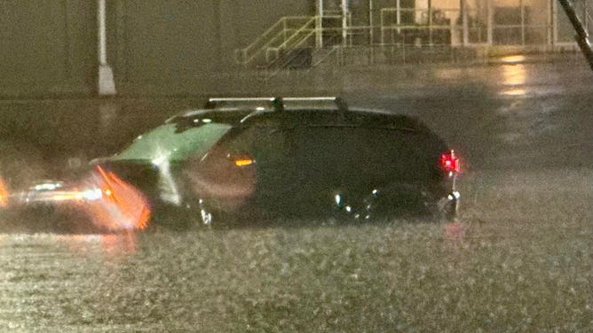
Millions of people in the southeastern U.S. spent Monday preparing for the 13th straight day of severe weather Monday as major cities from Florida to the Carolinas were smacked by powerful thunderstorms and flooding rain.
This latest threat came after more than 20 people were killed, including children and first responders, after a relentless barrage of tornadoes and historic flash flooding across several states.
![]() Image 1 of 51
Image 1 of 51POPLAR BLUFF, MISSOURI - APRIL 06: An aerial view shows floodwaters spilling from a road and a farm field on April 06, 2025 near Poplar Bluff, Missouri. Thunderstorms, heavy rains, high winds and tornadoes have plagued the regions for the past several days causing widespread damage. (Photo by Scott Olson/Getty Images) ( )
![FALMOUTH, KENTUCKY - APRIL 5: Pendleton County Search and Rescue take county electricians on a boat to turn off an electrical box in a flooded park on April 5, 2025 in Falmouth, Kentucky. Falmouth, Kentucky is expected to experience record flooding as the Licking River continues to rise. (Photo by Michael Swensen/Getty Images)]() Image 2 of 51
Image 2 of 51FALMOUTH, KENTUCKY - APRIL 5: Pendleton County Search and Rescue take county electricians on a boat to turn off an electrical box in a flooded park on April 5, 2025 in Falmouth, Kentucky. Falmouth, Kentucky is expected to experience record flooding as the Licking River continues to rise. (Photo by Michael Swensen/Getty Images) ( )
![This aerial view shows damage left by a reported tornado in Jeffersontown, Kentucky, on April 6, 2025. Violent storms battering the central-eastern US have killed at least 16 people, officials said, with the National Weather Service warning on April 6 of "severe" flash flooding in the coming days. A line of fierce storms stretching from Arkansas to Ohio has damaged buildings, flooded roadways and produced dozens of tornadoes in recent days. (Photo by LEANDRO LOZADA / AFP) (Photo by LEANDRO LOZADA/AFP via Getty Images)]() Image 3 of 51
Image 3 of 51This aerial view shows damage left by a reported tornado in Jeffersontown, Kentucky, on April 6, 2025. Violent storms battering the central-eastern US have killed at least 16 people, officials said, with the National Weather Service warning on April 6 of "severe" flash flooding in the coming days. A line of fierce storms stretching from Arkansas to Ohio has damaged buildings, flooded roadways and produced dozens of tornadoes in recent days. (Photo by LEANDRO LOZADA / AFP) (Photo by LEANDRO LOZADA/AFP via Getty Images) ( )
![This aerial view shows damage left by a reported tornado in Jeffersontown, Kentucky, on April 6, 2025. Violent storms battering the central-eastern US have killed at least 16 people, officials said, with the National Weather Service warning on April 6 of "severe" flash flooding in the coming days. A line of fierce storms stretching from Arkansas to Ohio has damaged buildings, flooded roadways and produced dozens of tornadoes in recent days. (Photo by LEANDRO LOZADA / AFP) (Photo by LEANDRO LOZADA/AFP via Getty Images)]() Image 4 of 51
Image 4 of 51This aerial view shows damage left by a reported tornado in Jeffersontown, Kentucky, on April 6, 2025. Violent storms battering the central-eastern US have killed at least 16 people, officials said, with the National Weather Service warning on April 6 of "severe" flash flooding in the coming days. A line of fierce storms stretching from Arkansas to Ohio has damaged buildings, flooded roadways and produced dozens of tornadoes in recent days. (Photo by LEANDRO LOZADA / AFP) (Photo by LEANDRO LOZADA/AFP via Getty Images) ( )
![This aerial view shows damage left by a reported tornado in Jeffersontown, Kentucky, on April 6, 2025. Violent storms battering the central-eastern US have killed at least 16 people, officials said, with the National Weather Service warning on April 6 of "severe" flash flooding in the coming days. A line of fierce storms stretching from Arkansas to Ohio has damaged buildings, flooded roadways and produced dozens of tornadoes in recent days. (Photo by LEANDRO LOZADA / AFP) (Photo by LEANDRO LOZADA/AFP via Getty Images)]() Image 5 of 51
Image 5 of 51This aerial view shows damage left by a reported tornado in Jeffersontown, Kentucky, on April 6, 2025. Violent storms battering the central-eastern US have killed at least 16 people, officials said, with the National Weather Service warning on April 6 of "severe" flash flooding in the coming days. A line of fierce storms stretching from Arkansas to Ohio has damaged buildings, flooded roadways and produced dozens of tornadoes in recent days. (Photo by LEANDRO LOZADA / AFP) (Photo by LEANDRO LOZADA/AFP via Getty Images) ( )
![FRANKFORT, KENTUCKY - APRIL 6: City and county workers create a sandbag wall as the Kentucky River rises on April 6, 2025 in Frankfort, Kentucky. Frankfort is expected to experience record flooding as the Kentucky River continues to rise. (Photo by Michael Swensen/Getty Images)]() Image 6 of 51
Image 6 of 51FRANKFORT, KENTUCKY - APRIL 6: City and county workers create a sandbag wall as the Kentucky River rises on April 6, 2025 in Frankfort, Kentucky. Frankfort is expected to experience record flooding as the Kentucky River continues to rise. (Photo by Michael Swensen/Getty Images) ( )
![FRANKFORT, KENTUCKY - APRIL 6: Houses evacuated are shown as the Kentucky River rises on April 6, 2025 in Frankfort, Kentucky. Frankfort is expected to experience record flooding as the Kentucky River continues to rise. (Photo by Michael Swensen/Getty Images)]() Image 7 of 51
Image 7 of 51FRANKFORT, KENTUCKY - APRIL 6: Houses evacuated are shown as the Kentucky River rises on April 6, 2025 in Frankfort, Kentucky. Frankfort is expected to experience record flooding as the Kentucky River continues to rise. (Photo by Michael Swensen/Getty Images) ( )
![POPLAR BLUFF, MISSOURI - APRIL 06: Floodwater covers a roadway on April 06, 2025 in Poplar Bluff, Missouri. Thunderstorms, heavy rains, high winds, and tornadoes have plagued the regions for several days, causing widespread damage. (Photo by Scott Olson/Getty Images)]() Image 8 of 51
Image 8 of 51POPLAR BLUFF, MISSOURI - APRIL 06: Floodwater covers a roadway on April 06, 2025 in Poplar Bluff, Missouri. Thunderstorms, heavy rains, high winds, and tornadoes have plagued the regions for several days, causing widespread damage. (Photo by Scott Olson/Getty Images) ( )
![Flooding along Cincinnati's riverfront parks on April 5, 2025.]() Image 9 of 51
Image 9 of 51Flooding along Cincinnati's riverfront parks on April 5, 2025. (Cincinnati Parks)
![Ohio River flooding in Cincinnati, Ohio on April 5, 2025.]() Image 10 of 51
Image 10 of 51Ohio River flooding in Cincinnati, Ohio on April 5, 2025. (Matt Bruning/ODOT)
![A giant hole in this resident's home exposes a car parked in the garage.]() Image 11 of 51
Image 11 of 51A giant hole in this resident's home exposes a car parked in the garage. (FOX Weather)
![More debris is mangled and piled up as crews work to clean up the damages caused by a tornado's extreme winds.]() Image 12 of 51
Image 12 of 51More debris is mangled and piled up as crews work to clean up the damages caused by a tornado's extreme winds. (FOX Weather)
![A field of damaged cars, wood, and home items littered the area after the tornado struck the small city.]() Image 13 of 51
Image 13 of 51A field of damaged cars, wood, and home items littered the area after the tornado struck the small city. (FOX Weather)
![Crews begin cleaning up all the debris and damages caused by the devastating tornado outbreak.]() Image 14 of 51
Image 14 of 51Crews begin cleaning up all the debris and damages caused by the devastating tornado outbreak. (FOX Weather)
![Piles of debris caused by the tornado sit mangled with a downed tree.]() Image 15 of 51
Image 15 of 51Piles of debris caused by the tornado sit mangled with a downed tree. (FOX Weather)
![Flooding in Hopkinsville, Kentucky.]() Image 16 of 51
Image 16 of 51Flooding in Hopkinsville, Kentucky. (Kirkman Aerial Photography / Facebook)
![Flooding in Hopkinsville, Kentucky.]() Image 17 of 51
Image 17 of 51Flooding in Hopkinsville, Kentucky. (Kirkman Aerial Photography / Facebook)
![Flooding in Hopkinsville, Kentucky.]() Image 18 of 51
Image 18 of 51Flooding in Hopkinsville, Kentucky. (Kirkman Aerial Photography / Facebook)
![On Saturday, witnesses captured video of what appeared to be a large building floating down the swollen Kentucky River in Frankfort, Kentucky, amid catastrophic flooding.]() Image 19 of 51
Image 19 of 51On Saturday, witnesses captured video of what appeared to be a large building floating down the swollen Kentucky River in Frankfort, Kentucky, amid catastrophic flooding. (Todd Daugherty via Storyful)
![Hanging Rock Hill in Madison, Indiana.]() Image 20 of 51
Image 20 of 51Hanging Rock Hill in Madison, Indiana. (The Attic Coffee Mill Cafe)
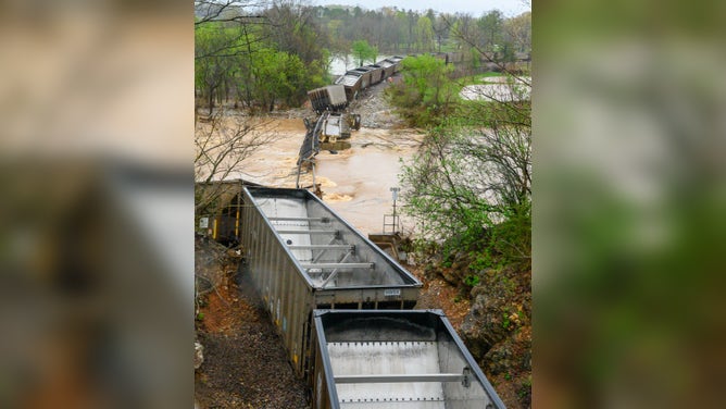
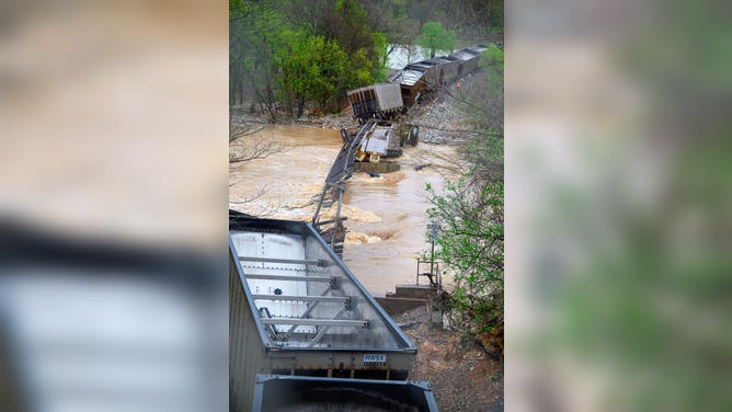
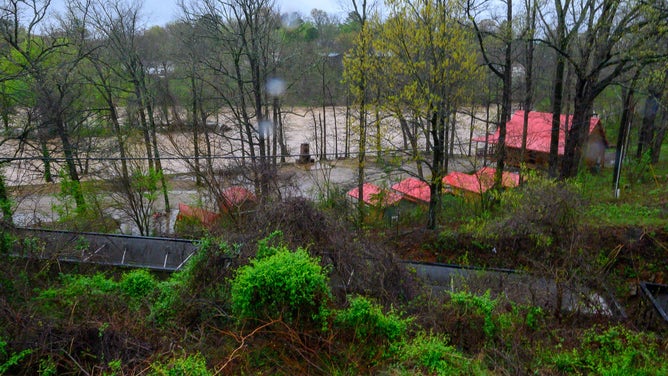
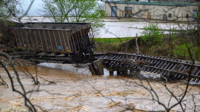
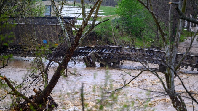
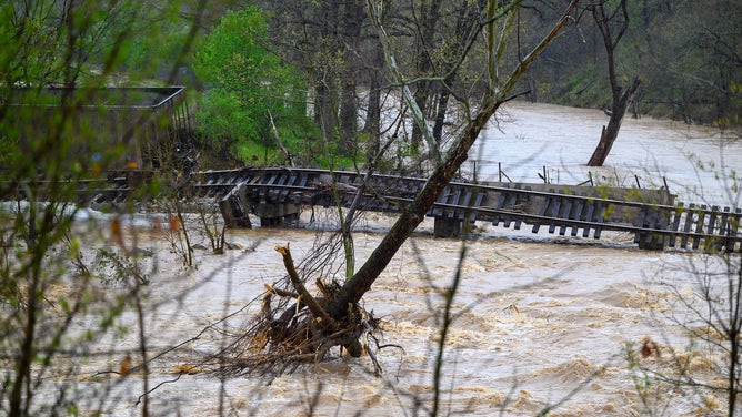
![Train derails in Arkansas state park]() Image 21 of 51
Image 21 of 51A trail derailed as the Warm Fork Spring River flooded during severe storms on April 5, 2025. (Donell Russell)
![Train derails in Arkansas state park]() Image 22 of 51
Image 22 of 51A trail derailed as the Warm Fork Spring River flooded during severe storms on April 5, 2025. (Donell Russell)
![Train derails in Arkansas state park]() Image 23 of 51
Image 23 of 51A trail derailed as the Warm Fork Spring River flooded during severe storms on April 5, 2025. (Donell Russell)
![Train derails in Arkansas state park]() Image 24 of 51
Image 24 of 51Warm Fork Spring River floods during severe storms on April 5, 2025. (Donell Russell)
![Train derails in Arkansas state park]() Image 25 of 51
Image 25 of 51Warm Fork Spring River floods during severe storms on April 5, 2025. (Donell Russell)
![Train derails in Arkansas state park]() Image 26 of 51
Image 26 of 51Warm Fork Spring River floods during severe storms on April 5, 2025. (Donell Russell)
![Train derails in Arkansas state park]() Image 27 of 51
Image 27 of 51A trail derailed as the Warm Fork Spring River flooded during severe storms on April 5, 2025. (Donell Russell)
![Train derails in Arkansas state park]() Image 28 of 51
Image 28 of 51A trail derailed as the Warm Fork Spring River flooded during severe storms on April 5, 2025. (Donell Russell)
![Train derails in Arkansas state park]() Image 29 of 51
Image 29 of 51A trail derailed as the Warm Fork Spring River flooded during severe storms on April 5, 2025. (Donell Russell)
![]() Image 30 of 51
Image 30 of 51Storm damage is seen April 5, 2025, at a home in Memphis, Tennessee, after a tree fell on it. (Celena Sanchez)
![Flooding seen on April 4, 2025 in Washington County, Kentucky.]() Image 31 of 51
Image 31 of 51Flooding seen on April 4, 2025 in Washington County, Kentucky. (Washington County Sheriff's Office, Kentucky)
![Flooding in Texarkana, Texas during a Flash Flood Emergency on Friday, April 4, 2025.]() Image 32 of 51
Image 32 of 51Flooding in Texarkana, Texas during a Flash Flood Emergency on Friday, April 4, 2025. (Texarkana Police Department)
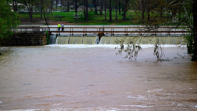
![Storms Bring Powerful Winds, Tornadoes, And Potentially Catastrophic Rainfall To Central U.S.]() Image 33 of 51
Image 33 of 51HOPKINSVILLE, KENTUCKY - APRIL 04: In an aerial view, water covers roadways following extreme flooding that has caused significant damage throughout the area on April 04, 2025 in Hopkinsville, Kentucky. A state of emergency has be declared in response to rising waters and the hazardous conditions they have created across the community. (Jason Davis)
![Flooding in Van Buren, MO.]() Image 34 of 51
Image 34 of 51(Robbie Mesey)
![Flooding in Van Buren, MO.]() Image 35 of 51
Image 35 of 51Flooding in Van Buren, MO. (Robbie Mesey)
![Flooding in Van Buren, MO.]() Image 36 of 51
Image 36 of 51Flooding in Van Buren, MO. (Robbie Mesey)
![Flooding in Van Buren, Missouri]() Image 37 of 51
Image 37 of 51Flooding in Van Buren, Missouri on April 4, 2025. (Robbie Mesey)
![Flooding in West Plains, MO]() Image 38 of 51
Image 38 of 51Flooding in West Plains, MO (Missouri Division of Fire Safety)
![Flooding in West Plains, MO]() Image 39 of 51
Image 39 of 51Flooding in West Plains, MO (Missouri Division of Fire Safety)
![Flooding in West Plains, MO]() Image 40 of 51
Image 40 of 51Flooding in West Plains, Missouri on April 4, 2025. (Missouri Division of Fire Safety)
![Flooding in Hopkinsville, Kentucky]() Image 41 of 51
Image 41 of 51Aerial footage of flooding in Hopkinsville, Kentucky on April 4, 2025. (Kirkman Aerial Photography)
![Flooding in Hopkinsville, Kentucky]() Image 42 of 51
Image 42 of 51Aerial footage of flooding in Hopkinsville, Kentucky on April 4, 2025. (Kirkman Aerial Photography)
![Flooding in Hopkinsville, Kentucky]() Image 43 of 51
Image 43 of 51Aerial footage of flooding in Hopkinsville, Kentucky on April 4, 2025. (Kirkman Aerial Photography)
![Flooding in Hopkinsville, Kentucky]() Image 44 of 51
Image 44 of 51Aerial footage of flooding in Hopkinsville, Kentucky on April 4, 2025. (Kirkman Aerial Photography)
![Flooding in Hopkinsville, Kentucky]() Image 45 of 51
Image 45 of 51Aerial footage of flooding in Hopkinsville, Kentucky on April 4, 2025. (Kirkman Aerial Photography)
![Flooding in Hopkinsville, Kentucky]() Image 46 of 51
Image 46 of 51Aerial footage of flooding in Hopkinsville, Kentucky on April 4, 2025. (Kirkman Aerial Photography)
![Flooding in Hopkinsville, Kentucky]() Image 47 of 51
Image 47 of 51Aerial footage of flooding in Hopkinsville, Kentucky on April 4, 2025. (Kirkman Aerial Photography)
![Flooding in Hopkinsville, Kentucky]() Image 48 of 51
Image 48 of 51Aerial footage of flooding in Hopkinsville, Kentucky on April 4, 2025. (Kirkman Aerial Photography)
![Flooding in Hopkinsville, Kentucky]() Image 49 of 51
Image 49 of 51Aerial footage of flooding in Hopkinsville, Kentucky on April 4, 2025. (Kirkman Aerial Photography)
![Flooding in Hopkinsville, KY]() Image 50 of 51
Image 50 of 51Flooding in Hopkinsville, KY ( )
![Flooding in Hopkinsville, KY]() Image 51 of 51
Image 51 of 51Flooding in Hopkinsville, KY ( )


Severe Thunderstorm Warnings and Tornado Warnings were issued across portions of the Southeast before sunrise ahead of the Monday morning commute.
In Leon County, Florida, local offices began cleaning up damage from a likely tornado in Tallahassee Monday afternoon.
A photo showed crews cleaning up fallen trees and debris from the side of a road.

Leon County Public Works clears debris from a road after severe weather on April 7, 2025.
(Leon County Government/Facebook / FOX Weather)
Severe weather was possible from the Southeast to the mid-Atlantic throughout the day and into Monday evening, but the risk wasn't near as dire as it was over the past two weeks.
However, it only takes one storm to turn lives upside down. So, be sure to download the free FOX Weather app and enable notifications to be alerted to severe weather or changes to the forecast in your area.
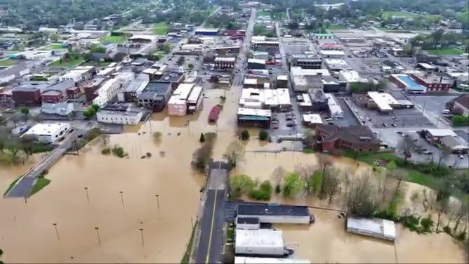
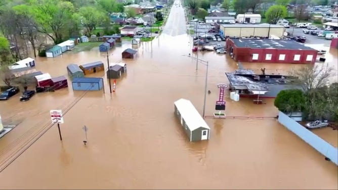
SEE IT: DRONE VIDEOS SHOW PARTS OF KENTUCKY TOWNS DISAPPEAR UNDER FLOODWATERS

(FOX Weather)
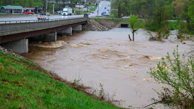
Nearly 18 million people in six states, from Florida to Virginia, were at risk of severe weather on Monday. However, NOAA's Storm Prediction Center (SPC) placed nearly 7.5 million people in the Southeast and the Carolinas in a Level 2 out of 5 threat on its severe thunderstorm risk scale.
This threat zone included cities such as Tallahassee in Florida, Savannah in Georgia, Columbia in South Carolina and Raleigh and Fayetteville in North Carolina.
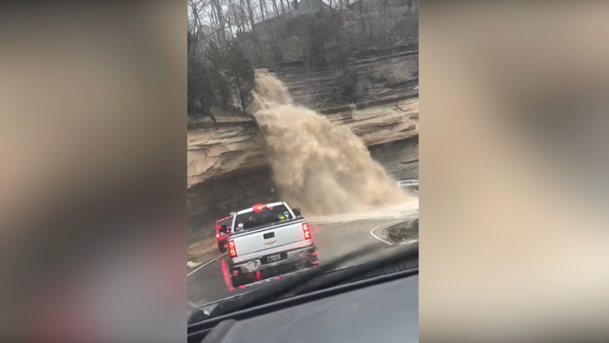
FEARS OF RIVER FLOODING RISE IN MISSISSIPPI, OHIO VALLEYS AMID MANDATORY EVACUATIONS

(FOX Weather)
The FOX Forecast Center said that ahead of the cold front moving across the region, torrential precipitation is likely to cause rivers and streams to overflow their banks, leading to a risk of flash flooding.
NOAA's Weather Prediction Center (WPC) said there's a risk of flooding from Alabama to Virginia. However, the WPC placed parts of southern and south-central Alabama and the western Florida Panhandle in a Level 2 out of 4 risk.