Millions brace for active stretch of severe weather across Midwest, South lasting through Easter weekend
Severe thunderstorms packing large hail, damaging winds and even tornadoes could impact millions of Americans from the Midwest to the Mississippi Valley.

Renewed severe storm threat arrives in Midwest, Mississippi Valley starting Wednesday through end of week
An active stretch of severe weather is expected to develop late this week and continue into the weekend with the most significant threats likely on Thursday and Friday in the short term, the FOX Forecast Center said.
KANSAS CITY, Mo. – An active stretch of severe weather is expected to develop late this week and continue into Easter weekend, with the most significant threats likely Thursday and Friday.
Severe thunderstorms packing large hail, damaging winds and even tornadoes could impact millions of Americans from the Midwest to the Mississippi Valley.

(FOX Weather)
The unsettling forecast starts Wednesday night in southeastern Nebraska, central and eastern Kansas and northwestern Oklahoma after an already-active start to the severe weather season.
"Since April 1, we have only had three days where we haven't had some sort of severe storm threat," FOX Weather Meteorologist Zack Green said.
DOWNLOAD THE FREE FOX WEATHER APP

A Mississippi family survived a devastating EF-4 tornado that ripped through their home, leaving them injured and one of their dogs dead, while their other dog, Linus, went missing for ten agonizing days. Hope emerged when a drone pilot utilized thermal technology to locate Linus alive amidst the wreckage, leading to an emotional reunion and a beacon of light for the shattered family.
(Jason Miller/Raven 6 Rising / FOX Weather)
Residents in cities such as Kansas City, Missouri; Wichita, Kansas; and Omaha, Nebraska, are urged to monitor forecasts for the possibility of large hail and damaging wind gusts. While the immediate threat of tornadoes is considered low for Wednesday night, Green emphasizes that it is still a "non-zero threat."
"Completely different story once we make our way into Thursday as well as Friday," Green said.
Thursday is when the severe weather potential significantly increases and expands across parts of the Plains and into the Midwest.

(FOX Weather)
About 11 million people are under threat Thursday from strong winds, large hail and the possibility of tornadoes, with the greatest risk centered on eastern Nebraska, northern Missouri and Iowa.
The FOX Forecast Center said temperatures that are expected to reach into the 80s in cities such as Omaha and Kansas City will further fuel storm development.
The severe weather threat intensifies and broadens even further on Friday, potentially affecting over 40 million people from the southern Plains to the Great Lakes. Numerous thunderstorms are expected to erupt across a large but relatively narrow corridor stretching from Detroit down to Oklahoma City and potentially as far south as Dallas.
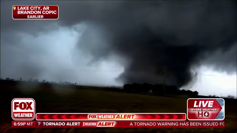
File – FOX Weather exclusive storm chaser finds terrifying tornado in Arkansas
Brandon Copic was chasing storms in Arkansas when a massive wedge tornado formed in front of him.
"Friday, I think, is my point of concern," Green notes.
Depending on the system's evolution, damaging winds, large hail and tornadoes will all be possible. Even areas farther north, like Minneapolis, could see strong thunderstorms, while a dryline setting up in western Texas could spark isolated severe storms.
Easter weekend remains active
The active weather pattern is not expected to end with the workweek. Rounds of severe storms are likely to continue throughout the Easter weekend.
![This graphic shows the severe weather threat on Saturday, April 19, 2025.]() Image 1 of 2
Image 1 of 2This graphic shows the severe weather threat on Saturday, April 19, 2025. (FOX Weather)
![This graphic shows the severe weather threat on Sunday, April 20, 2025.]() Image 2 of 2
Image 2 of 2This graphic shows the severe weather threat on Sunday, April 20, 2025. (FOX Weather)

