3 dead in severe weather outbreak that tore through South this week
Mississippi suffered three fatalities, Mississippi Emergency Management Agency confirmed, as the dangerous storm system charged eastward, threatening the Carolinas and Eastern Seaboard with additional tornadoes and damaging winds on Wednesday.

Destructive severe weather outbreak tears across the South
A severe weather outbreak unfolded across the Plains and Southeast on Monday and Tuesday spawning multiple tornadoes, hurricane-force winds and disrupting Mardi Gras events. FOX Weather meteorologist Steve Bender breaks down the damage reports over the past two days and the concerns for the east coast on Wednesday.
IRVING, Texas – Deadly severe storms ripped across the South on Tuesday, unleashing destructive winds and isolated tornadoes. The widespread outbreak generated more than 160 severe weather reports and left hundreds of thousands without power.
Three people were killed and at least half a dozen others injured, according to the Mississippi Emergency Management Agency, as the dangerous storm system charged eastward, threatening the Carolinas and Eastern Seaboard with additional tornadoes and damaging winds on Wednesday.
Two of the deaths were reported in Madison County, Mississippi, and the third fatality occurred in Clarke County, MEMA said.
The FOX Forecast Center said dangerous gusty winds continue to be the most prevalent threat from this line of storms, causing damage and power outages as far east as Nashville, Tennessee, on Tuesday.
By Tuesday night, the NWS had issued more than 40 Tornado Warnings and 160 Severe Thunderstorm Warnings. During the height of the storms on Tuesday morning, over 400,000 customers lost power in Texas, while over 100,000 were left without power in Alabama on Tuesday evening.
Tornadoes were confirmed across Texas, Oklahoma and Louisiana as part of the ongoing severe weather outbreak.
Law enforcement in Gramercy, part of the New Orleans metro area, reported a possible tornado Tuesday evening with structural damage.
Possible tornado damage in Gramercy, Louisiana on March 4, 2025.
(Gramercy Police Department)
West of New Orleans in Ascension Parish, law enforcement responded to a possible tornado on Tuesday evening that damaged five homes in the community of Darrow.
"Well, this weather certainly was not on our bingo card for 2025 Mardi Gras. Fortunately, things appear to have calmed down in our area," Ascension Parish Sheriff's Office wrote on social media.
Damage to a home in Darrow, Louisiana on March 4, 2025 after a possible tornado touch down.
(Ascension Parish Sheriff's Office)
Gusty winds slammed into Louisiana on Tuesday, bringing a gust of 70 mph in Fort Polk, where a trailer was overturned.
According to damage reports, a roof was blown off a building in downtown Lake Charles. The video below shows traffic lights moving in the wind.

Wind rocks traffic lights in Saint Charles
A line of severe thunderstorms brought powerful wind gusts to Louisiana on Tuesday, including in Lake Charles, where this video shows traffic lights swinging in the wind.
Multiple trees have also been reported to have fallen onto homes in Natchitoches, Louisiana, according to the NWS.
Weather doesn't wash out Mardi Gras in New Orleans

Soaking rains briefly dampen the Mardi Gras party in New Orleans
Heavy rains sent Mardi Gras partygoers fleeing for shelter in New Orleans' French Quarter as a line of severe storms swept through Tuesday evening.
It was a windy Fat Tuesday in New Orleans throughout the day, with a peak gust reported of 67 mph, but that didn't stop the celebrations.
The city's iconic parades adapted to the storms, with the Zulu and Rex krewes shortening their parade routes and starting earlier than usual.
FOX Weather Correspondent Robert Ray reports that despite the severe weather forecast, the crowds were still out in their Mardi Gras best, holding onto their costumes in the windy conditions.
Lightning sparks multiple fires in Alabama
As the line of storms swept into Alabama Tuesday evening, the combination of frequent lightning and dry conditions led to multiple fire starts.
The National Weather Service reported brush fires in Cleveland and Asheville, Alabama, with a structure fire triggered by lightning near Tuscaloosa.
Lightning sparked several wildfires in Lexington, the NWS reported.
Severe weather damage strewn across Texas, Oklahoma communities
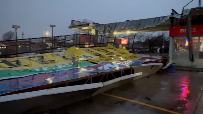
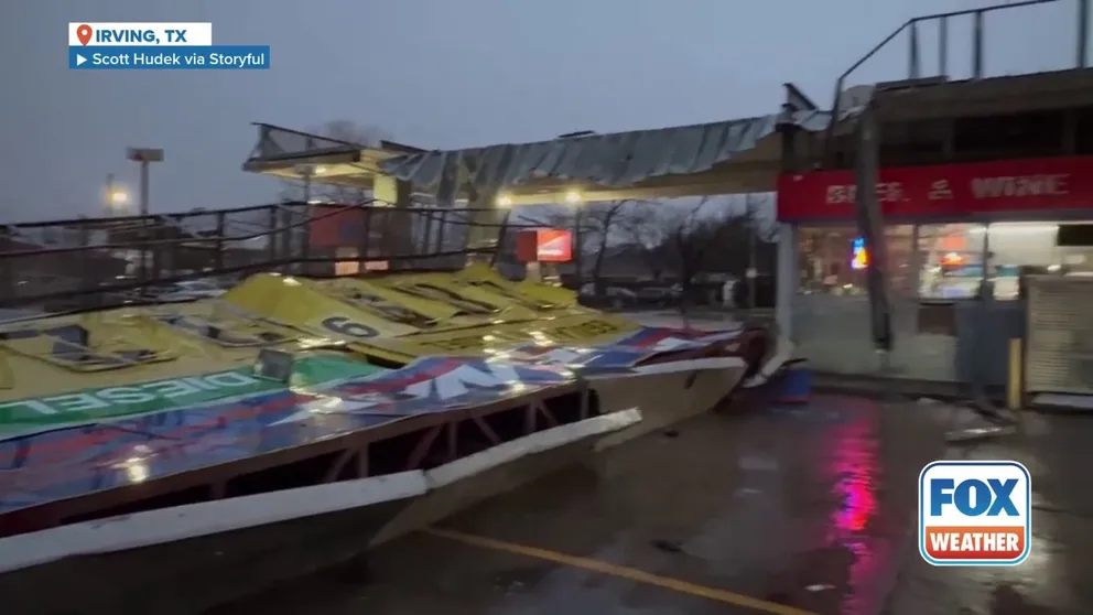
![A large gas station sign was toppled in Irving, Texas, in the early hours of Tuesday morning, March 4, as a line of storms brought winds of up to 70 mph to the Dallas-Fort Worth metroplex.]() Image 1 of 8
Image 1 of 8A large gas station sign was toppled in Irving, Texas, in the early hours of Tuesday morning, March 4, as a line of storms brought winds of up to 70 mph to the Dallas-Fort Worth metroplex. ( Scott Hudek via Storyful)
![]() Image 2 of 8
Image 2 of 8This photo shows significant damage to the roof of the Irving Family Advocacy Center on Tuesday, March 4, 2025. (City of Irving)
![This photo shows damage after straight-line winds in Kingsland, Texas, on Tuesday, March 4, 2025.]() Image 3 of 8
Image 3 of 8This photo shows damage after straight-line winds in Kingsland, Texas, on Tuesday, March 4, 2025. (@DavidAlfWx/X)
![This photo shows damage after straight-line winds in Kingsland, Texas, on Tuesday, March 4, 2025.]() Image 4 of 8
Image 4 of 8This photo shows damage after straight-line winds in Kingsland, Texas, on Tuesday, March 4, 2025. (@DavidAlfWx/X)
![This photo shows damage after straight-line winds in Kingsland, Texas, on Tuesday, March 4, 2025.]() Image 5 of 8
Image 5 of 8This photo shows damage after straight-line winds in Kingsland, Texas, on Tuesday, March 4, 2025. (@DavidAlfWx/X)
![This image shows damage reported in Irving, Texas, after severe thunderstorms blasted across the city on Tuesday, March 4, 2025.]() Image 6 of 8
Image 6 of 8This image shows damage reported in Irving, Texas, after severe thunderstorms blasted across the city on Tuesday, March 4, 2025. (Irving Police Department/X)
![This image shows damage reported in Irving, Texas, after severe thunderstorms blasted across the city on Tuesday, March 4, 2025.]() Image 7 of 8
Image 7 of 8This image shows damage reported in Irving, Texas, after severe thunderstorms blasted across the city on Tuesday, March 4, 2025. (Irving Police Department/X)
![This image shows damage reported in Irving, Texas, after severe thunderstorms blasted across the city on Tuesday, March 4, 2025.]() Image 8 of 8
Image 8 of 8This image shows damage reported in Irving, Texas, after severe thunderstorms blasted across the city on Tuesday, March 4, 2025. (Irving Police Department/X)


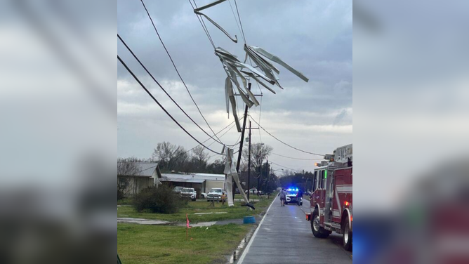
First responders raced to communities across parts of Texas and Oklahoma that were affected by the initial stages of the severe weather outbreak Monday night and into Tuesday morning.
One person was injured in Ada, Oklahoma, by a tornado after severe storms passed through the area, causing significant damage to structures, power lines and trees.
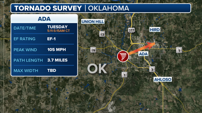
Ada, Oklahoma tornado survey results.
(FOX Weather)
National Weather Service teams from Norman were already on the ground surveying the storm damage, and the initial assessment found damage from an EF-1 tornado with peak winds of 105 mph.
The EF-1 tornado knocked out power to thousands and displaced 24 families, according to City of Ada officials.
TORNADO STRIKES DALLAS SUBURB AS SEVERE WEATHER OUTBREAK SWEEPS SOUTH
Watch: Gas station sign toppled during tornado-warned storm in Irving, Texas
Scott Hudek captured this footage Tuesday morning showing the huge gas sign lying at the entrance to a Raceway station in Irving, Texas. The roof and sign of the gas station was also seen damaged, with broken metal hanging down over the filling station’s service window.
Damaging wind gusts have also been reported across the region, including in Hillsboro, Texas. The city reported a 62-mph wind gust early Tuesday morning, while Dallas Fort Worth International Airport reported a 74-mph wind gust, which is as strong as a Category 1 hurricane. A second round of severe weather brought 60-mph gusts to the Dallas-Fort Worth Metroplex and eerily orange skies from a dust storm.
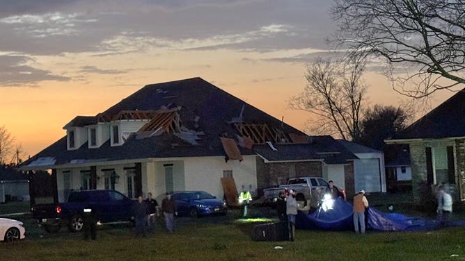
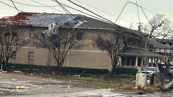
Irving, Texas, was also hit hard by the storms. An EF-1 tornado caused significant damage to multiple apartment buildings, leaving 350 people displaced, officials said.

Tornado leaves trail of damage in Irving, Texas
Over 350 people were displaced after an EF-1 tornado blasted through Irving, Texas Tuesday morning.
Numerous reports said tractor-trailers were knocked over during the severe weather. According to a report from FOX 4 Dallas, a tractor-trailer was blown over on Interstate 35 in Glenn Heights near the Dallas-Ellis County line.
Major damage was also reported in the community of Lewisville, Texas.

Severe weather wrecks Lewisville, Texas warehouse
A partial building collapse was reported at the Benjamin Moore Paint warehouse in Lewisville, Texas, off Highway 121, during severe storms that rolled through the area on Tuesday morning.
Officials said the storms moved through Lewisville around 5:30 a.m. local time, bringing down multiple power lines and trees and causing power outages across the city.
Video recorded in Lewisville shows damage after an apparent roof collapse at a Benjamin Moore Paint warehouse in the city. Some of the walls were ripped away from the structure, and pieces of yellow insulation were found scattered across the area.
Multiple injuries were also reported in Camp County, Texas, after storms knocked over several camping trailers at Big Al's Barefoot Bay in the community of Pittsburgh.
This photo shows significant damage to the roof of the Irving Family Advocacy Center on Tuesday, March 4, 2025.
(City of Irving / FOX Weather)
A photo shared by officials shows significant damage to the roof of the Irving Family Advocacy Center building. Officials said a temporary shelter has been set up for those impacted by the severe weather.
According to a report from FOX 4 Dallas, the tin roof at Plano West High School was ripped off by powerful winds as the storms tore through the area on Tuesday. One of the school's football coaches suggested that the damage also impacted the gym and locker room.

Roof partially torn off Texas high school during severe storms
Part of the tin roof on Plano West Senior High School was torn off during severe weather Tuesday morning. No injuries have been reported (Video Credit: KDFW).
FOX 4 Dallas said that school was still in session on Tuesday, and the damaged areas have been closed off.
Power outages skyrocketed for much of the day, with more than 400,000 outages reported in Texas, according to FindEnergy.com.
Two more EF-1 tornadoes were confirmed by the NWS office in Shreveport, Louisiana, from early Tuesday morning.
The first tornado occurred at 9 a.m. CT east of the Texas-Louisiana state line in Caddo Parish with a maximum wind speed of 93 mph, according to the NWS. Another tornado briefly touched down in the Highlands neighborhood of North Shreveport at 9:19 a.m. CT, with a maximum wind speed of 93 mph.