100 million brace for severe weather outbreak as tornadoes, hurricane-force winds threaten weekend weather
The FOX Forecast Center has been closely monitoring computer forecast models since last week, and while some severe weather occurred Wednesday and is possible again Thursday, forecasters are most concerned about what is likely to take place Friday and over the weekend.

Severe weather risk update for the weekend
The FOX Forecast Center says more than 100 million people across at least 30 states are under an increased threat for severe weather through Sunday.
Fast Facts:
- Dangerous severe weather outbreak has over 100 million people in more than 30 states on alert starting Friday.
- Potential for destructive, hurricane-force wind gusts and strong tornadoes has forecasters concerned.
- Final days of storms to slam East Coast on Sunday from Florida to Northeast.
More than 100 million people in the central and eastern U.S. are being urged to prepare for a potentially dangerous multiday severe weather outbreak that could unleash thunderstorms capable of producing hurricane-force wind gusts and strong tornadoes starting Friday.
NIGHTTIME TORNADOES: HOW YOU CAN STAY SAFE FROM NOCTURNAL TWISTERS
The FOX Forecast Center said an outbreak of severe weather is likely Friday afternoon and could potentially last into the overnight hours as the powerful storm system continues to intensify while it spins across the central U.S.
All severe weather hazards are possible, including swaths of potentially destructive wind gusts and strong tornadoes (EF-2 or higher).

(FOX Weather)
In fact, forecasters said the highest risk for tornadoes stretches more than 750 miles from Iowa to Mississippi, while the overall tornado threat spans over 1,000 miles.
The FOX Forecast Center said the main action will come in the form of a powerful squall line of storms, which is expected to develop Friday afternoon across Missouri and Iowa and charge off to the east through the Mississippi Valley.
Moisture from the Gulf will initially be limited, but the FOX Forecast Center said it will eventually be pulled north into the Mississippi Valley and could reach as far north as Iowa, southwestern Wisconsin and northern Illinois.
WATCH VS. WARNING: HERE ARE THE DIFFERENCES BETWEEN THESE WEATHER TERMS THAT COULD SAVE YOUR LIFE
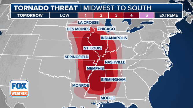
This graphic shows the tornado threat on Friday, March 14, 2025.
(FOX Weather)
STAY OR GO? TRUSTING YOUR GUT CAN BE LIFESAVING WHEN MULTIPLE WEATHER WARNINGS ARE ISSUED
Nearly 70 million people are at risk of severe weather on Friday. However, the SPC has placed more than 6.5 million people in portions of Missouri, Iowa, Illinois, Kentucky, Tennessee and Arkansas in a level 4 out of 5 risk of severe weather.
Cities like St. Louis in Missouri and Springfield, Decatur and Champaign in Illinois are among the cities in the highest threat zone.
New Orleans, Atlanta on alert for powerful thunderstorms on Saturday

(FOX Weather)
The powerful storm system will continue to move off to the east on Saturday, placing tens of millions of people from the Gulf Coast to the southern Great Lakes at risk of strong to severe thunderstorms.
Questions remain with regard to how the atmosphere will destabilize on Saturday, particularly in areas farther north.
However, the FOX Forecast Center said a corridor of rich Gulf moisture is expected to set up from central and southern Mississippi into northern Alabama, creating a favorable environment for severe weather ahead of the surging cold front.
With some strong wind shear in place, conditions will allow for the development of supercell thunderstorms and the eventual development of another fast-moving squall line.
Thunderstorms could again produce hail, damaging winds and tornadoes, and torrential rain could lead to some flooding issues.
Currently, the SPC has placed more than 6.5 million people from Louisiana to Alabama in a level 4 out of 5 risk of severe weather.
This includes cities like New Orleans and Baton Rouge in Louisiana and Birmingham, Mobile and Montgomery in Alabama.
STAY OR GO? TRUSTING YOUR GUT CAN BE LIFESAVING WHEN MULTIPLE WEATHER WARNINGS ARE ISSUED
More than 45 million from Florida to Northeast face severe weather threat on Sunday

(FOX Weather)
On Sunday, an area of concern has emerged for tens of millions of people along the East Coast, including the heavily traveled Interstate 95 corridor from the Southeast and mid-Atlantic to the Northeast.
"Sunday's severe threat, while expansive, the threat for hail and tornadoes drops and is just a damaging wind threat," the FOX Forecast Center said.
The SPC has placed more than 45 million people from northern Florida to New Jersey in a level 2 out of 5 threat for severe weather on Sunday.
This includes many major cities, such as Savannah, Georgia; Charleston, South Carolina; Raleigh, North Carolina; Richmond, Virginia; Washington; Baltimore and Philadelphia.