Southern city could see a top five worst snowstorm in recorded history from brewing major winter storm
Winter Storm Watches are in effect in areas of Texas, Oklahoma, Arkansas, New Mexico, Missouri and northern Louisiana, as a potentially historic winter storm is expected to create chaotic travel conditions with dangerous levels of snow and ice, combined with temperatures nearing zero.

Potentially historic winter storm in the coming days
FOX Weather Meteorologist Kiyana Lewis breaks down the potentially historic winter conditions looming across the U.S., with the storm spanning over 2,000 miles and reaching 30 states.
OKLAHOMA CITY, Okla. – A major winter storm is forecast to take shape in the Southern Plains on Friday, and it'll pump significant snow and ice into a region that rarely ever sees forecasts of such magnitudes. The storm will start out west and will enter the Southern Plains with locals beginning to experience the initial impacts by as early as Friday afternoon.
The storm could create chaotic travel conditions as dangerous levels of snow and ice are forecast in an area that doesn't typically experience major winter weather events of this scale.
Winter Storm Watches are now in effect across portions of Texas, Oklahoma, Arkansas, New Mexico, Missouri and northern Louisiana, and will remain in place from Friday through Saturday. Major cities under these watches include Dallas, Oklahoma City and Little Rock.
(FOX Weather)
With freezing temperatures expected to linger through the weekend, Oklahoma City will primarily see a snow event that could potentially etch this winter storm into the Sooner State's history books.

This graphic displays top two-day snow records in Oklahoma City.
(FOX Weather)
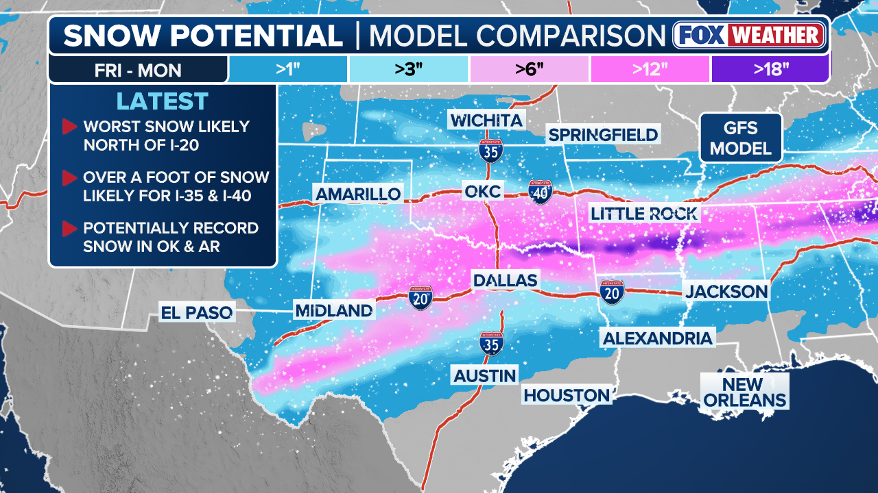
While there is still uncertainty about how much snow Oklahoma City will see, forecast models are coming into better agreement with over 6 inches of snow possible, according to the FOX Forecast Center.

This graphic displays the average monthly snow totals in Oklahoma City.
(FOX Weather)
The initial round of precipitation will begin as rain across areas such as Dallas and Little Rock on Friday afternoon. However, as colder air surges in at the surface while warmer air remains aloft, freezing rain will quickly develop.
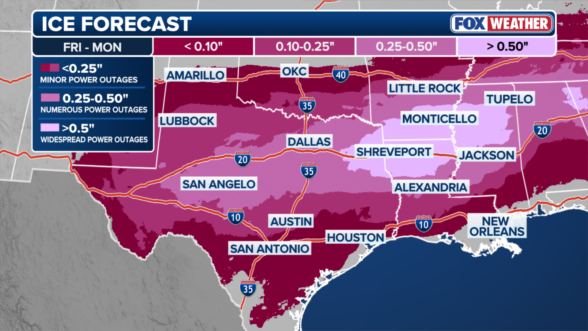
During the overnight hours Friday into early Saturday, widespread icing is expected from Midland, Texas, through Dallas and Shreveport, Louisiana, and into southern Arkansas.
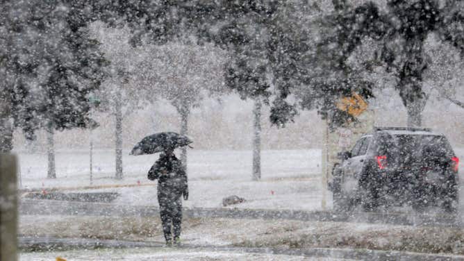
FILE: A man walks on the snow covered sidewalk while the snow fall at Norman, Oklahoma, USA. 24 January 2023.
(Photo by Tharaka Basnayaka/NurPhoto via Getty Images / Getty Images)
Central Oklahoma through northern Arkansas and into Tennessee will receive the highest snowfall totals, as these regions will see less freezing rain due to the entire atmospheric column remaining below freezing through the weekend, according to the FOX Forecast Center.
A wide swath of 5-8 inches looks likely with some bigger totals across Oklahoma where they could exceed over a foot. The heaviest snow and ice are expected from Saturday morning through midday Sunday.

(FOX Weather)
Through Sunday, a high impact swath of ice accretion is possible, with a bullseye of 0.50 inches or more of ice from far eastern Texas through southern Arkansas and into northwestern Mississippi.
HOW MUCH ICE IS NEEDED TO KNOCK OUT POWER, DAMAGE TREES?
Widespread power outages are likely in these areas. Elsewhere, locations from west Texas through Dallas may see around 0.25 to 0.50 inches of ice. This would be sufficient to cause numerous power outages and severely disrupt travel along major interstates such as I-20 and I-35 into Sunday.
(FOX Weather)
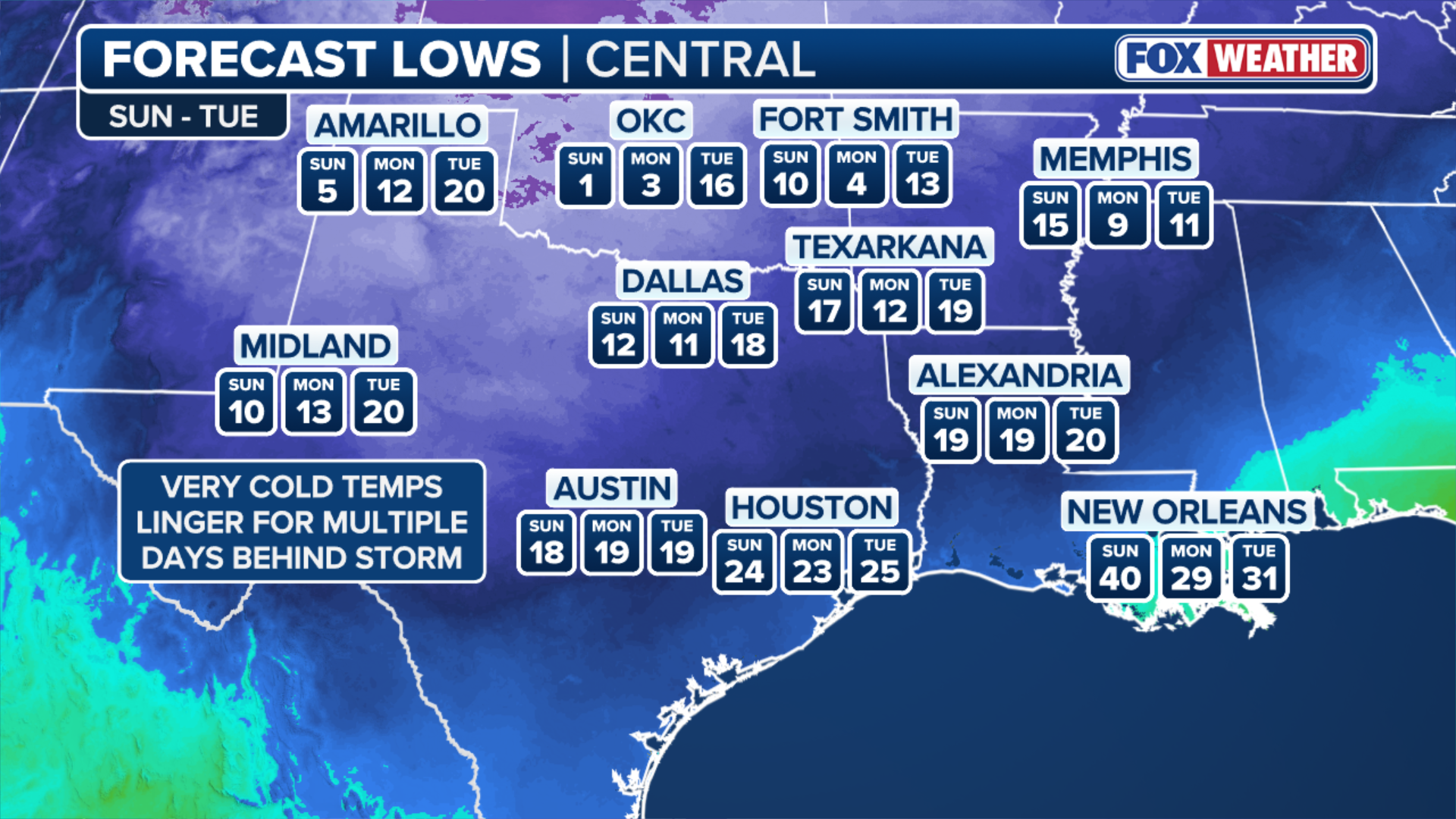
Behind the freezing rain and snow, frigid temperatures will move in, helping to lock in any ice and snow that falls through the weekend.
Locations from Dallas to Little Rock could wake up to temperatures in the single digits or even below zero by Monday morning, nearly 30 to 40 degrees below average.
According to the FOX Forecast Center, temperatures on back-to-back days are forecast to be teetering below zero in Oklahoma City as the region prepares to face the extremely rare, major winter storm.
(FOX Weather)
The debilitating effects of a crippling ice storm, combined with extremely low temperatures, could set the stage for a potentially catastrophic event if the forecast materializes.
Check back for updates on this developing story.