Multiple searches underway as monster storms slam California with rounds of heavy rain and feet of snow
A dip in the jet stream has opened the door for rounds of storms to bring abundant rain and snow into the West Coast, after weeks of dry weather.

California mountains slammed by blizzard conditions, 10 feet of snow could fall across Sierra peaks
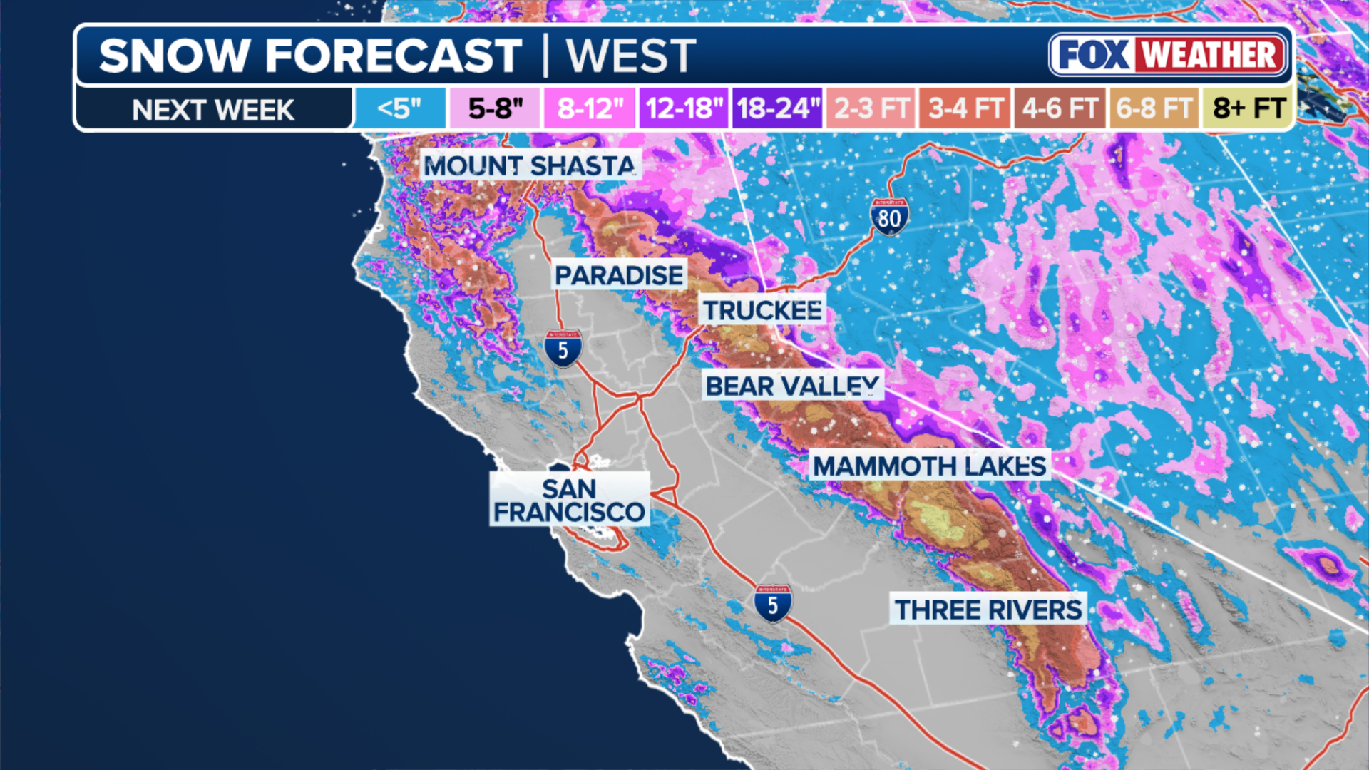
Snow will continue to fall into Wednesday as yet another system off the coast sustains a seemingly endless supply of Pacific moisture into California. The snow intensity will diminish during the day as the upper-level low moves directly overhead; however, as it does so, snow levels may drop below 1,000 feet. Officials are advising people to avoid travel in the Sierras. As much as 10 feet of snow could fall across the peaks of the Sierras through Saturday.
LOS ANGELES – Multiple searches are underway across California as first responders battle heavy rain and flooding in the southern part of the state while blizzard conditions are pummeling the Sierra.
San Bernardino County officials are searching for a person who was swept away after driving into a flooded road late Tuesday night north of Devore Heights, the county fire department said. The rain is expected to finally taper off through Wednesday.
Meanwhile, the search is ongoing for nine skiers who are still missing in Northern California after an avalanche in Truckee late Tuesday morning, the Nevada County Sheriff's Office said.
The third round of a series of storms from the Pacific Ocean is moving onshore across Northern California Wednesday and may bring flurries even to elevations below 1,000 feet.
![PASADENA, CALIFORNIA - FEBRUARY 16: Motorists drive through rainfall as a storm delivers heavy rain to the region on February 16, 2026 in Pasadena, California.]() Image 1 of 5
Image 1 of 5PASADENA, CALIFORNIA - FEBRUARY 16: Motorists drive through rainfall as a storm delivers heavy rain to the region on February 16, 2026 in Pasadena, California. ((Photo by Mario Tama/Getty Images))
![CALIFORNIA, USA - FEBRUARY 16: Cars pass on flooding water at Sawtelle neighborhood during heavy rain in Los Angeles, California, United States on February 16, 2026.]() Image 2 of 5
Image 2 of 5CALIFORNIA, USA - FEBRUARY 16: Cars pass on flooding water at Sawtelle neighborhood during heavy rain in Los Angeles, California, United States on February 16, 2026. ((Photo by Tayfun Coskun/Anadolu via Getty Images))
![CALIFORNIA, USA - FEBRUARY 16: Women cross the street in Beverly Hills during heavy rain in Los Angeles, California, United States on February 16, 2026.]() Image 3 of 5
Image 3 of 5CALIFORNIA, USA - FEBRUARY 16: Women cross the street in Beverly Hills during heavy rain in Los Angeles, California, United States on February 16, 2026. ((Photo by Tayfun Coskun/Anadolu via Getty Images))
![CALIFORNIA, USA - FEBRUARY 16: A view of flash flood on I-405 Highway near Sawtelle neighborhood during heavy rain in Los Angeles, California, United States on February 16, 2026.]() Image 4 of 5
Image 4 of 5CALIFORNIA, USA - FEBRUARY 16: A view of flash flood on I-405 Highway near Sawtelle neighborhood during heavy rain in Los Angeles, California, United States on February 16, 2026. ((Photo by Tayfun Coskun/Anadolu via Getty Images))
![Snow blasts Lake Heavenly Resort, South Lake Tahoe California on Feb. 16, 2026.]() Image 5 of 5
Image 5 of 5Snow blasts Lake Heavenly Resort, South Lake Tahoe California on Feb. 16, 2026. (Robert Ray/FOX Weather)


A dip in the jet stream has opened the door for rounds of storms to bring abundant rain and snow into the West Coast, after weeks of dry weather.
Los Angeles was placed under a Severe Thunderstorm Warning early Wednesday, for just the sixth time in the past two years, as a final slug of storms moved across Southern California.
HERE'S WHAT TO DO IF YOU ENCOUNTER A FLOODED ROAD
According to the FOX Forecast Center, the county had gone eight years without such a warning (2016–2024).
A Level 1 out of 4 flash flood threat covered most of the California coast from just north of the Bay Area south through San Diego, through early Wednesday morning, but rain is expected to lighten through the day.

(FOX Weather)
Flooding was reported Monday across parts of California, after 1–2 inches of rain fell across the Los Angeles Basin and 3–5 inches of rain dropped across the Coastal Range north of the Bay Area.
Urban flooding swamped parts of LA, with water rising to the mid-door panels of some sedans in the Westwood neighborhood.

Video: Heavy street flooding in Los Angeles' Westwood neighborhood
Drivers had to contend with heavy street flooding Los Angeles' Westwood neighborhood on Monday, February 16, 2026, as the first of a series of storms moved over California.
Parts of Topanga Canyon Boulevard in L.A.'s Westside remain closed due to debris slides Monday.
A third round of less intense rain will target the state on Thursday.

Mudslide closes part of Highway 27 in Topanga Canyon.
(CaltransDist7/X / FOX Weather)
Snow blankets Sierras with feet of snow before heading to parched Rockies
Meanwhile, feet of snow are piling up in the Sierra. Snow intensity is expected to diminish somewhat through Wednesday after Tuesday's blizzard conditions.
However, another storm will track across Northern California Wednesday bringing rain to the Bay Area and snow to elevations just below 1,000 feet, creating the chance of flurries for places like Redding, which hasn't recorded measurable snow in three years.
9 SKIERS STILL MISSING AFTER SIERRA NEVADA AVALANCHE AMID EXTREME WEATHER CONDITIONS

(FOX Weather)
Over 30 inches of snow has been reported in numerous areas in the region, with localized amounts recording more than 40 inches of snow through Sunday.
Part of Interstate 80 remained closed early Wednesday from Colfax, California to the Nevada state line, due to intense winds and blowing snow, according to Caltrans.
Officials continue to discourage travel through the northern mountain passes.

Feet of snow piling up in Sierra Nevada mountains
Over two feet of snow has fallen in Sierra Nevada, causing travel issues as major interstates and passes remain impassable. FOX Weather Correspondent Robert Ray is live in Stateline, Nevada, with the latest.
In Southern California, intermittent snow is expected Wednesday, staying mostly confined to higher elevations above 3,000 feet. But those driving through the Grapevine on Interstate 5 should be aware of possible closures Wednesday night.
All told, the higher peaks of the Northern Sierra could tally up to 8 feet of snow through Friday, while Lake Tahoe and the San Gabriel Mountains could see up to 4 feet of snow.
(FOX Weather)
However, these storms will be beneficial for California's snowpack and the Rockies farther east, where some snowpacks are at record lows.
Utah is seeing record-low snow levels across the state.

Aerial images of ongoing snow drought around Salt Lake City, Utah.
(Robert Ray/FOX Weather / FOX Weather)
According to the FOX Forecast Center, current measurements show a snow-water equivalent of near 6 percent across the state, a low not seen since 1981.
Winter snow provides an essential water supply for drinking and agriculture across the West in the summer months.
Stay with FOX Weather for the latest on storms impacting California.