Third Pacific storm slams California with heavy rain, mudslides
Many areas will see 1-2 inches of rain, but others are expected to see up to 8 inches through Friday. But as the region is already saturated from the atmospheric river that passed through on Tuesday, the incoming storm may cause flooding.

Third Pacific storm to slam California with heavy rain, mudslides
After a brief break of relentless rain and snow, Northern California is bracing itself for yet another storm event starting Thursday evening. Meanwhile, storms will also hit the southern part of the state, where wildfire-embattled areas will welcome the rain.
Fast Facts
- At least two deaths were reported in Northern California as a result of Tuesday's storms.
- Friday will be the final round of heavy rain and snow as the atmospheric river exits the West.
- This storm system will become a major winter storm as it moves into the eastern U.S.
SAN FRANCISCO – The West Coast will see a final round of rain and snow Friday as a multi-day atmospheric river concludes and shifts eastward, becoming the nation's next big winter storm.
Northern California received the last round of rain and snow-producing storms on Thursday evening, after the atmospheric river event on Tuesday led to at least two confirmed deaths in Sonoma County, according to the county sheriff's office.
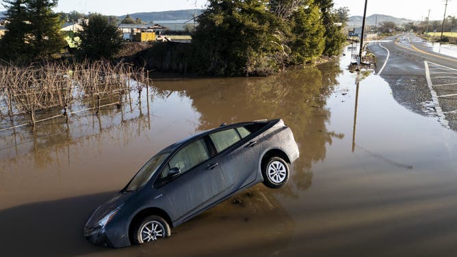
A vehicle is partially submerged in flood water along State Route 121 following an atmospheric river event near Schellville in Sonoma, Calif., Wednesday, Feb. 5, 2025.
(Stephen Lam / San Francisco Chronicle / FOX Weather)
More rain for saturated Northern California
The storm moved quickly Thursday night, bringing a surge of moisture to mountain ranges along the coast resulting in heavy rain for people at lower elevations.
Some areas have seen up to 24 inches of rain over the past week.

(FOX Weather)
Feet of snow for the Western mountains
In the higher elevations, moisture from the storm will produce a new round of very heavy snowfall for the Sierra Nevada and northern Rockies.
The FOX Forecast Center said an additional 1-2 feet or more of snow may accumulate through Friday, a welcome event for the below-average snowpack currently in the Sierras. Specifically, the Sierra Nevada range is expected to see a foot of snow on the eastern slopes.
This may cause very poor travel conditions in the Sierra Nevada from through Friday.
Outside of California, the National Weather Service has issued Winter Storm Warnings associated with this storm through Friday morning for a large part of Oregon, as well as Idaho and Montana.

(FOX Weather)
Rain for Southern California could put end of fire season within reach
A final round of storms is wrapping up in Southern California. Up to 1 inch of rain is possible in areas devastated by the Eaton and Palisades Fires. The rain will be light enough to see a reduction in the current fire threat without having to worry about burn scar mudslides.
With the catastrophic fires across Southern California finally contained, this next round of rain could help put an end to this devastating wildfire season for Los Angeles and Southern California, according to the FOX Forecast Center.
They said the rain is a very positive step toward, but not quite enough to completely end, the fire weather season for the region, which is experiencing rain deficits of 5-10 inches since October.

(FOX Weather)
Impacts from recent atmospheric river events in California
The latest storm comes as the region is still recovering from two massive atmospheric river storms since Saturday.
Sadly, the most recent storm has claimed at least two lives in Sonoma County. The sheriff's office confirmed deputies found a deceased person in a culvert on Wednesday, and a second body was recovered Thursday morning. No other details about the deaths were given.
Downtown San Francisco recorded 2.89 inches of rain on Tuesday, breaking a 138-year-old record that had stood since 1887. But the areas that saw the highest rain totals since Friday were areas north of Sacramento, with Paradise, California, reporting over 20 inches.
Such heavy rainfall pours into California's two biggest reservoirs, Lake Shasta and Lake Oroville, which have risen 15 feet since just Friday.
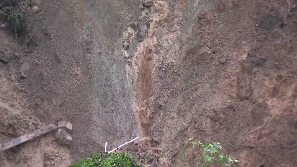
Mudslide caused by atmospheric river sends home in to river in Sonoma County, CA
Rains from a multiday atmospheric river triggered a landslide that pushed a home into the Russian River in Forestville, CA (Video Credit: KTVU).
Where there is heavy rain, however, there are often mudslides, as was the case in parts of Northern California.
SAN FRANCISCO SLAMMED BY DAMAGING WINDS AS ATMOSPHERIC RIVER EVENT SOAKS NORTHERN CALIFORNIA
One of the structural casualties was a Sonoma County home, which toppled into the Russian River in the North Bay Area. The Sonoma County Sheriff's office said the home was unoccupied.
![CALIFORNIA, USA - FEBRUARY 4: A large slide takes out a whole house dumping in to the Russian River during heavy rain in Forestville of Sonoma County, California, United States on February 4, 2025 as an atmospheric river hits Northern California.]() Image 1 of 5
Image 1 of 5CALIFORNIA, USA - FEBRUARY 4: A large slide takes out a whole house dumping in to the Russian River during heavy rain in Forestville of Sonoma County, California, United States on February 4, 2025 as an atmospheric river hits Northern California. (Tayfun Coskun/Anadolu)
![CALIFORNIA, USA - FEBRUARY 4: A large slide takes out a whole house dumping in to the Russian River during heavy rain in Forestville of Sonoma County, California, United States on February 4, 2025 as an atmospheric river hits Northern California.]() Image 2 of 5
Image 2 of 5CALIFORNIA, USA - FEBRUARY 4: A large slide takes out a whole house dumping in to the Russian River during heavy rain in Forestville of Sonoma County, California, United States on February 4, 2025 as an atmospheric river hits Northern California. (Tayfun Coskun/Anadolu)
![CALIFORNIA, USA - FEBRUARY 4: A large slide takes out a whole house dumping in to the Russian River during heavy rain in Forestville of Sonoma County, California, United States on February 4, 2025 as an atmospheric river hits Northern California.]() Image 3 of 5
Image 3 of 5CALIFORNIA, USA - FEBRUARY 4: A large slide takes out a whole house dumping in to the Russian River during heavy rain in Forestville of Sonoma County, California, United States on February 4, 2025 as an atmospheric river hits Northern California. (Tayfun Coskun/Anadolu )
![CALIFORNIA, USA - FEBRUARY 4: A large slide takes out a whole house dumping in to the Russian River during heavy rain in Forestville of Sonoma County, California, United States on February 4, 2025 as an atmospheric river hits Northern California.]() Image 4 of 5
Image 4 of 5CALIFORNIA, USA - FEBRUARY 4: A large slide takes out a whole house dumping in to the Russian River during heavy rain in Forestville of Sonoma County, California, United States on February 4, 2025 as an atmospheric river hits Northern California. (Tayfun Coskun/Anadolu)
![Flood water from the Russian River inundates vineyards off Wohler Road, near Windsor, Calif., on Tuesday, Feb. 4, 2025.]() Image 5 of 5
Image 5 of 5Flood water from the Russian River inundates vineyards off Wohler Road, near Windsor, Calif., on Tuesday, Feb. 4, 2025. (Alvin A.H. Jornada/San Francisco Chronicle)


The department issued an evacuation order for low-lying areas along the river just before 9 p.m. Tuesday night.
The multiday atmospheric river also brought damaging winds, taking down a swath of trees around an elementary school in Santa Rosa, California. The Santa Rosa Fire Department said no one was hurt.

High winds from atmospheric river brings down trees at Sonoma County, California school
High winds from an atmospheric river brought down trees at a Santa Rosa elementary school in Sonoma County, California on Monday. No injuries were reported (Video Credit: Santa Rosa Fire Department).
The strongest winds were recorded along the coast, north of San Francisco, including a gust of 90 mph. A 69 mph wind gust was recorded at San Francisco International Airport as a severe thunderstorm moved through, toppling trees and downing power lines in the city.
The San Francisco Fire Department said one person was hospitalized after being struck by a falling tree.