Timeline: Historic winter storm begins its sweep across the country, when will it reach your area?
A potentially historic major winter storm, tracking 2,300 miles across the U.S., has begun. Here is a timeline of when and where the potentially historic winter storm will arrive in your area, and what current forecasts predict it will deliver.

Historic winter storm could impact over 235 million Americans
A dangerous winter storm is on the way for the U.S. and is expected to impact over 40 states, spanning more than 2,000 miles. National Weather Service Director Ken Graham joins FOX Weather to discuss this historic winter storm and how it will affect residents.
A potentially historic major winter storm stretching more than 2,300 miles across the U.S. has begun. The system is expected to deliver harsh winter weather, impacting more than 245 million Americans across 40 states through Monday.
The FOX Forecast Center will be monitoring the winter storm that is expected to dump a combination of snow and freezing rain.
(FOX Weather)
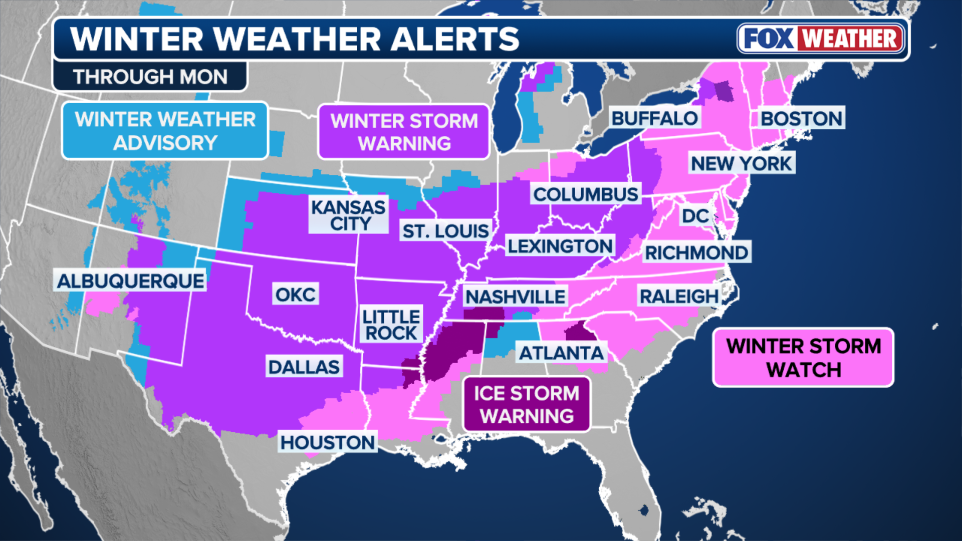
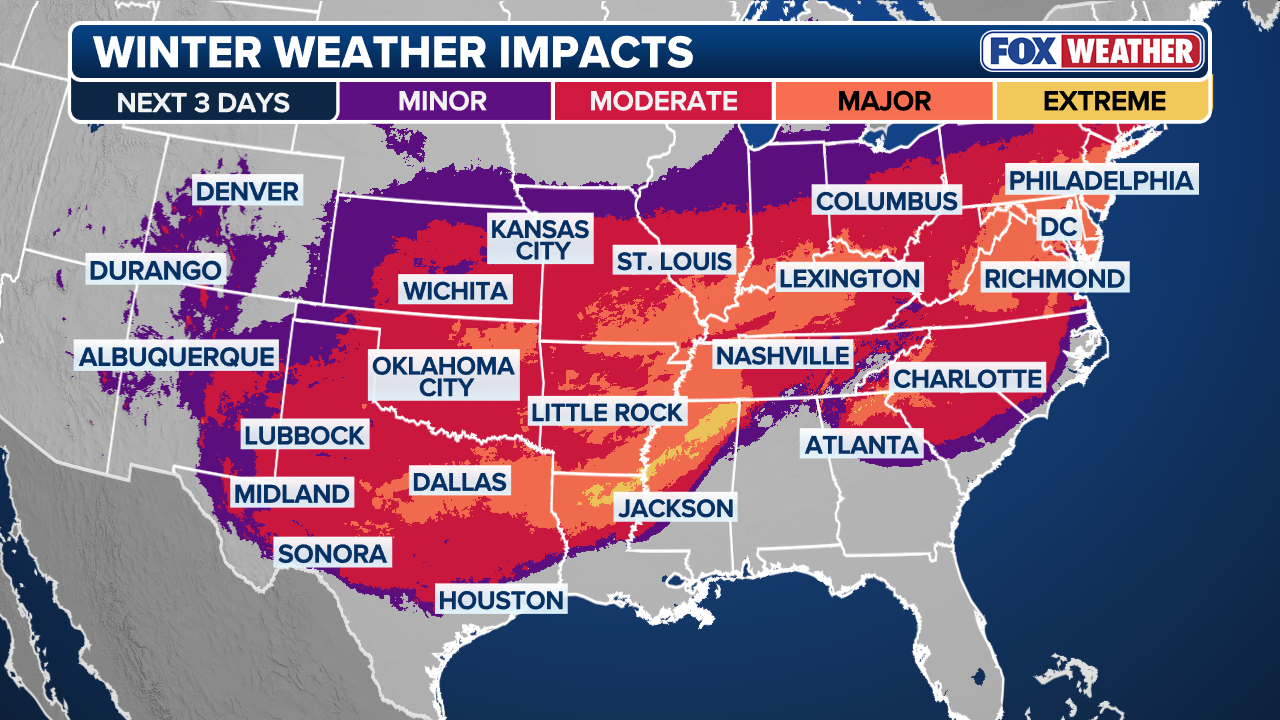
The monster winter storm has states from Arizona to Maine on watch, with Winter Storm Alerts issued from Albuquerque to Boston, placing nearly 194 million Americans now under alerts.
Here is a timeline of when and where the major winter storm will arrive in your area, and what current forecasts predict it will deliver.
(FOX Weather)
Saturday
CITIES IMPACTED: Dallas, Little Rock, Shreveport, Nashville, Memphis, Atlanta, Charlotte
INTERSTATES IMPACTED: I-40, I-20, I-65
AIRPORTS IMPACTED: BNA, LIT, SHV, MEM, ATL, CLT, HSV, BHM
(FOX Weather)
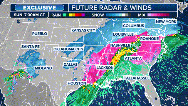
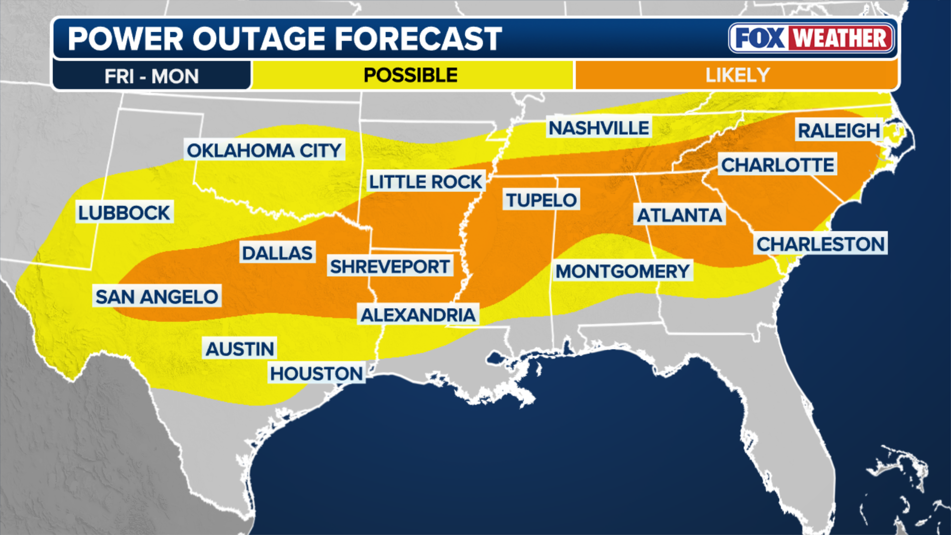
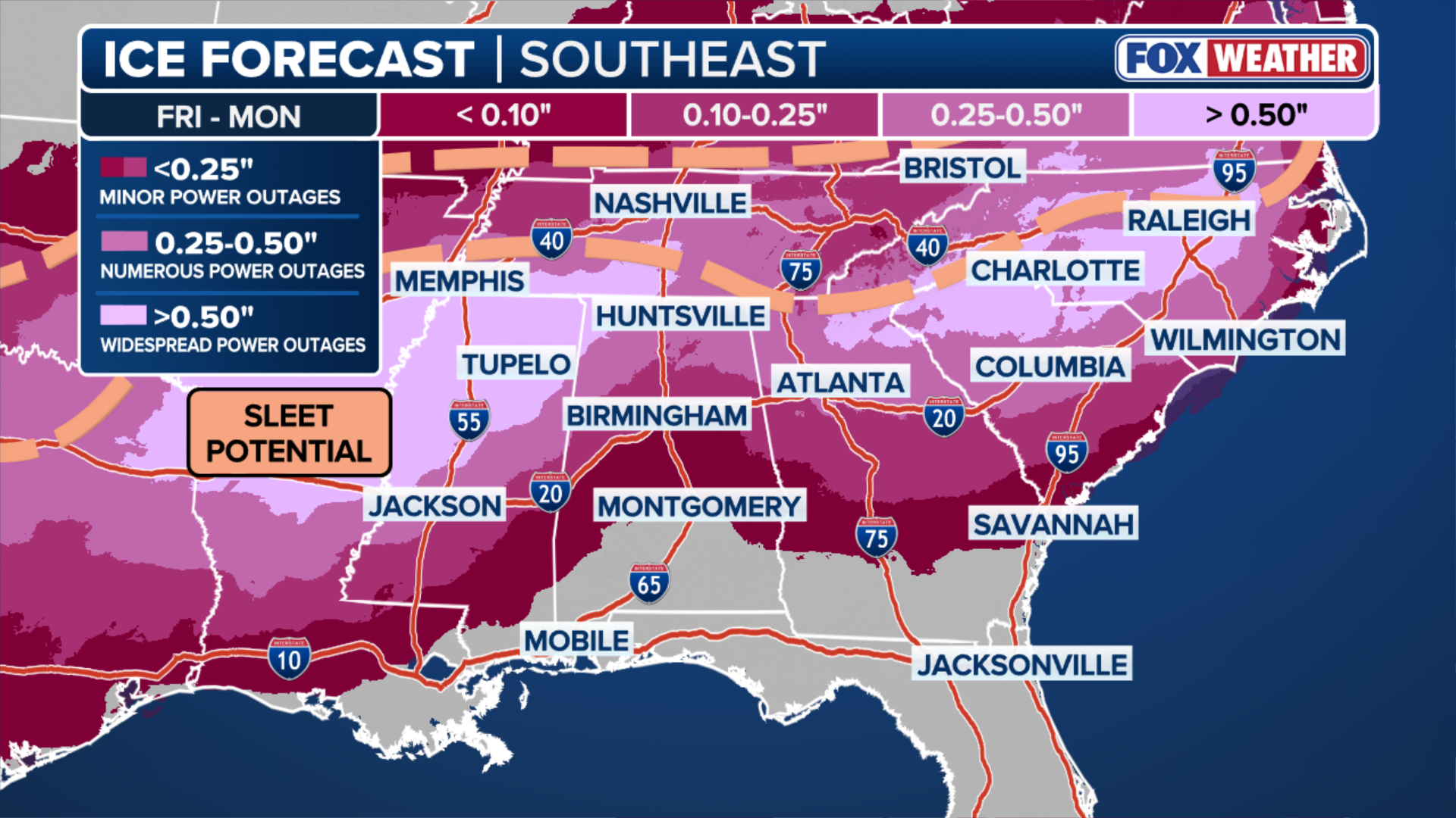
On Saturday, the high impact storm will begin to move into the Southeast, bringing crippling ice and snow to millions. From Mississippi into parts of the Carolinas, power outages will become increasingly likely due to ice and snow, triggering Ice Storm Warnings across 8 states from Arkansas to North Carolina.
WINTER STORM WARNING EXPLAINED: WHAT DOES IT MEAN AND WHEN IS IT ISSUED?
Winter weather will continue to impact Texas, Arkansas and Louisiana, and break into Tennessee, Kentucky, Georgia and into the Carolinas on Saturday.
Major cities, including Nashville, Memphis, Atlanta and Charlotte, and a number of major airports and interstates, will feel the effects.

(FOX Weather)
Widespread icing from Midland, Texas, to Dallas and Little Rock is likely throughout most of Saturday, threatening widespread power outages and significant travel disruptions.
Through Saturday afternoon, the storm will bring freezing rain to the Atlanta-Charlotte corridor.
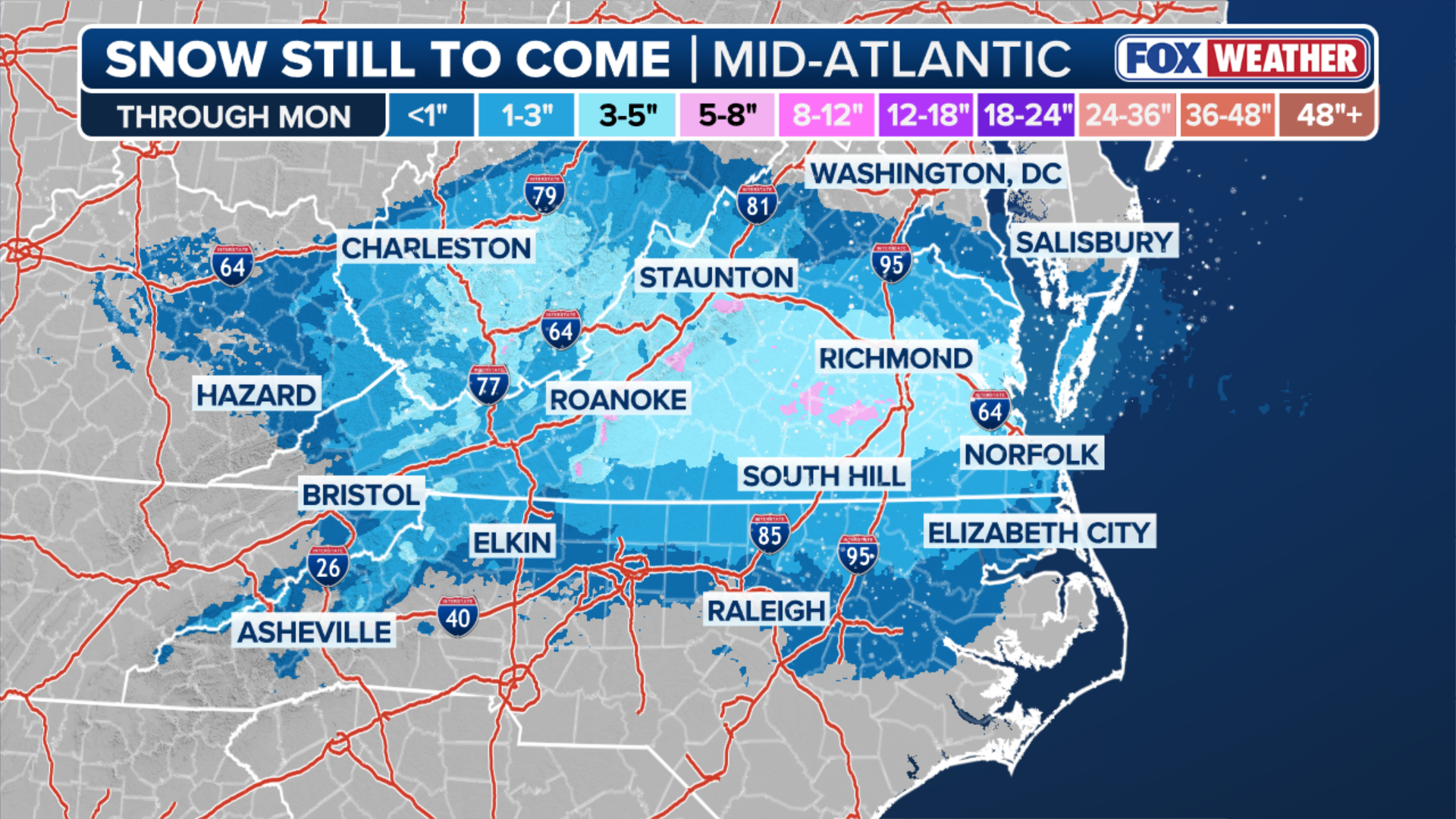
The highest snow totals will be confined to areas along and north of I-40 in Tennessee, specifically along the Cumberland Plateau and potentially into the southern Appalachians of East Tennessee and into Kentucky. Those areas are expected to see significant snow, with Louisville expected to see between 8 and 12 inches of snow.
(FOX Weather)
On Saturday afternoon, snow begins to work its way in from the west across Virginia and West Virginia and sets up for a massive Sunday in the Northeast, Mid-Atlantic and Southeast.
Sunday
CITIES IMPACTED: Nashville, Atlanta, Columbia, Raleigh, Wilmington, Richmond, Washington, Philadelphia, New York City
INTERSTATES IMPACTED: I-81, I-95, I-20, I-40, I-75
AIRPORTS IMPACTED: ATL, BNA, RDU, PHL, DCA, LGA, ROA, JFK, EWR

FILE - A resident shovels snow during a storm in Hudson, New York, US, on Sunday, Jan. 7, 2024. Hundreds of flights have been grounded across the US from a pair of winter storms that left more than a foot of snow in New York's Hudson Valley and sparked blizzard warnings across the Great Plains.
(Angus Mordant/Bloomberg via Getty Images / Getty Images)
As the sun rises Sunday morning, snow will be falling from northern Virginia to potentially as far north as the New York tri-state area.
Impacts will continue to be felt in the Southeast through Nashville, Atlanta, Columbia, Raleigh, Wilmington and Richmond.
The storm will peak in intensity through the day and into the evening, with snow rates potentially reaching as high as 2–3 inches per hour.
(FOX Weather)
Winter Storm Warnings are now in place across most of the Northeast, including Washington, DC, New York City, Philadelphia and Boston and will last into Monday.
Major interstates and airports across the East Coast could see travel delays and cancellations as the biggest snowstorm in years dumps snow across parts of the Mid-Atlantic and Northeast.
(FOX Weather)
Monday
CITIES IMPACTED: New York, Philadelphia, Washington
INTERSTATES IMPACTED: I-81, I-95, I-80
AIRPORTS IMPACTED: EWR, LGA, JFK, PHL, DCA

(FOX Weather / FOX Weather)
With the storm forecast winding down on Monday from west to east, snow and ice will stick around as extremely low temperatures across affected areas will lock in winter weather.
Winter weather will likely persist in the Northeast, including New York City and Philadelphia, as the storm wraps up, with the potential for snow to linger across portions of New England into Monday evening as the area of low pressure pulls away from the coast.
In the South, locations from Dallas to Little Rock could wake up to temperatures in the single digits or even below zero by Monday morning, nearly 30 to 40 degrees below average.

(FOX Weather)
Temperatures across the Southeast will remain frigid through the early part of next week, leading to prolonged impacts for areas affected by ice and snow.
Cities from Atlanta to Raleigh and Wilmington will see temperatures running 15 to 20 degrees below average, with daytime highs struggling to even reach the freezing mark for millions.
HOW TO STAY SAFE FROM DANGEROUS WINTER ICE
Overnight lows are forecast to plunge into the 20s—and potentially the teens—through Tuesday and Wednesday mornings in some areas of the Southeast. This persistent deep freeze will cause any daytime melting to refreeze, creating hazardous black ice and further complicating power restoration and recovery efforts.