Tropical disturbance 96L development chances fade as Saharan dust takes hold
Environmental conditions earlier in the week looked conducive for additional development of this system, but the system failed to take advantage. Now, Saharan dust and drier air in the vicinity has drastically cut 96L's chances for development.

Invest 96L struggling to survive amid Saharan dust, wind shear
What earlier in the week was looking like a future Tropical Storm Debby has instead run into hostile atmospheric conditions and its odds of development have plummeted. Still, it will bring heavy rains to the Windward Islands still reeling from Hurricane Beryl.
The tropics have been active this week in the Atlantic, with Hurricane Beryl plowing through the Caribbean Sea after its Category 4 landfall in the Windward Islands and another tropical disturbance being monitored for development several hundred miles behind it.

(FOX Weather)
Invest 96L in central tropical Atlantic
Showers and thunderstorms continue in association with an area of low pressure approaching the Windward Islands Wednesday.
The National Hurricane Center (NHC) has dubbed this system Invest 96L, which is simply a naming convention used by the NHC to identify areas it is investigating for possible development within the next several days.
Environmental conditions earlier in the week looked conducive for additional development of this system, but the system failed to take advantage. Now, Saharan dust and drier air in the vicinity has drastically cut 96L's chances for development to around 10-20% as of Wednesday.
The system is moving westward at 15-20 mph and while it is no longer expected to become a tropical depression or tropical storm, it is forecast to bring heavy rains to the Lesser Antilles that just took the brunt of Hurricane Beryl.
"The tough thing is for the Lesser Antilles and Windward Islands, we’re talking about heavy rain moving into an area that was just ripped apart. And that’s really tough," said FOX Weather Meteorologist Britta Merwin.
Merwin said there is enough wind shear in place and dry air and that is going to prevent 96L from getting its act together.
"So the good news is, we’re not expecting 96L to turn into anything," Merwin continued. "The bad news is it does still mean we have heavy rain and tropical rain into areas that have just been decimated… so that’s tough scenario — any type of weather moving into these areas is bad news."
Flash Flood Warnings are in effect for Barbadoes for an additional 1-3 inches of rain Wednesday. 96L could follow suit drenching Jamaica just days after that island deals with Beryl.

(FOX Weather)
Atlantic Basin climatology
The 2024 hurricane season in the Atlantic Basin is still ahead of schedule compared to a typical year.
According to NHC historical data, the fourth named storm typically forms by Aug. 15 and the second hurricane forms by Aug. 26.
WHY THE EASTERN CARIBBEAN IS KNOWN AS THE 'HURRICANE GRAVEYARD'
During an average season, 14 named storms form, with seven that strengthen into hurricanes.
The Atlantic hurricane season spans approximately 26 weeks and lasts through Nov. 30.
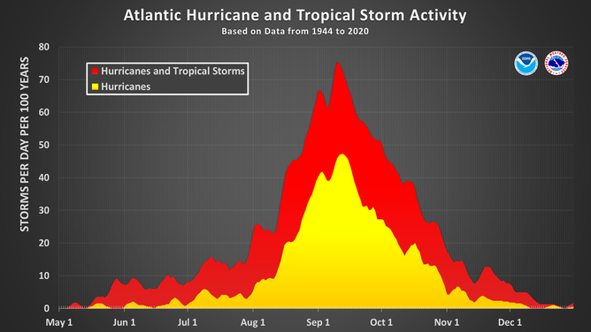
This chart shows the amount of tropical cyclone activity, in terms of named storms and hurricanes, that occurs in the Atlantic Basin on each calendar day between May 1 and Dec. 31. Specifically, it shows the number of hurricanes (yellow area) and the combined named storms and hurricanes (red area) that occur on each calendar day over a 100-year period. The chart is based on data from the 77-year period from 1944 to 2020 (starting at the beginning of the aircraft reconnaissance era) but normalized to 100 years. The official hurricane season for the Atlantic Basin is from June 1 to Nov. 30, but tropical cyclone activity sometimes occurs before and after these dates, respectively. The peak of the Atlantic hurricane season is Sept. 10, with most activity occurring between mid-August and mid-October.
(National Hurricane Center / NOAA)