Hurricane Helene produces ‘unsurvivable’ storm surge, over 1 million power outages
Hurricane Helene has made landfall in Florida’s Big Bend region, after intensifying into a catastrophic Category 4 hurricane with winds of 140 mph.

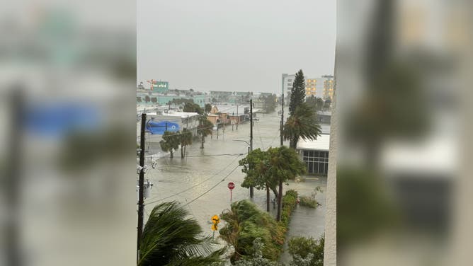
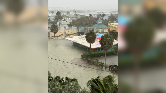
Storm surge from Hurricane Helene begins to overtake St. Pete Beach
FOX Weather Meteorologist Ian Oliver and his team battle powerful winds and rain to report on storm surge quickly coming into St. Pete Beach, Florida, Thursday night. Sept. 26, 2024.
TALLAHASSEE, Fla. – Hurricane Helene has made landfall in Florida’s Big Bend region, after intensifying into a catastrophic Category 4 hurricane with winds of 140 mph. The monster hurricane is unleashing a potentially "unsurvivable" 20-foot storm surge, catastrophic hurricane-force winds and flooding rain.
The National Weather Service in Tallahassee issued a rare Extreme Wind Warning for several counties in the Big Bend ahead of the approach of the eyewall.
The National Hurricane Center (NHC) said there is a significant risk of a life-threatening storm surge along the entire west coast of the Florida Peninsula, as well as Florida’s Big Bend region because of Hurricane Helene’s massive size.

(FOX Weather)
TRACKING HURRICANE HELENE: LIVE FORECAST CONE, SPAGHETTI MODELS, ALERTS, WIND PROJECTIONS AND MORE
The highest inundation, with as much as 20 feet of storm surge flooding, is expected from Carrabelle to the Suwannee River in Florida, with other locations like Apalachicola and Chassahowitzka forecast to see 10-15 feet of storm surge.
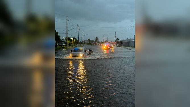
Power outages climb as Hurricane Helene's winds pummel Florida
After landfall, more than 1 million customers were without power in Florida, and outages were also climbing in Georgia and the Carolinas.
(FOX Weather)
"A catastrophic and deadly storm surge is likely along portions of the Florida Big Bend coast, where inundation could reach as high as 20 feet above ground level, along with destructive waves," the NHC warned. The National Weather Service in Tallahassee called the expected storm surge into Apalachee Bay "catastrophic and potentially unsurvivable."
FOX Weather's Ian Oliver said the surge quickly submerged streets around St. Pete Beach on Thursday evening, with high tide several hours away.
And further south in a community called Sunset Beach, local fire rescue said it would no longer respond to calls for service due to the flooding.
Clearwater Beach reported its highest surge since at least the Superstorm of 1993, with a level of more than 7 feet.
![Coastal flooding in St. Petersburg, Florida from Hurricane Helene.]() Image 1 of 23
Image 1 of 23Coastal flooding in St. Petersburg, Florida from Hurricane Helene. ( )
![ST PETE BEACH, FLORIDA - SEPTEMBER 26: The Gulf of Mexico's water pushes up against the beach as Hurricane Helene churns offshore on September 26, 2024 in St. Pete Beach, Florida. Later today, Helene is forecast to become a major hurricane, bringing the potential for deadly storm surges, flooding rain, and destructive hurricane-force winds along parts of the Florida West Coast. (Photo by Joe Raedle/Getty Images)]() Image 2 of 23
Image 2 of 23ST PETE BEACH, FLORIDA - SEPTEMBER 26: The Gulf of Mexico's water pushes up against the beach as Hurricane Helene churns offshore on September 26, 2024 in St. Pete Beach, Florida. Later today, Helene is forecast to become a major hurricane, bringing the potential for deadly storm surges, flooding rain, and destructive hurricane-force winds along parts of the Florida West Coast. (Photo by Joe Raedle/Getty Images) (Photo by Joe Raedle/Getty Images)
![Charles Starling, a lineman with Team Fishel, is pelted with rain as he walks by a row of electrical line trucks staged in a field in The Villages, Florida, on Thursday, Sept. 26, 2024.]() Image 3 of 23
Image 3 of 23Charles Starling, a lineman with Team Fishel, is pelted with rain as he walks by a row of electrical line trucks staged in a field in The Villages, Florida, on Thursday, Sept. 26, 2024. Thousands of the trucks are staged by Duke Energy in preparation for damage from Hurricane Helene. (Stephen M. Dowell/Orlando Sentinel/Tribune News Service via Getty Images) ( )
![ST PETE BEACH, FLORIDA - SEPTEMBER 26: Neil (who did not want to provide their last name) visits the beach as Hurricane Helene churns offshore on September 26, 2024, in St. Pete Beach, Florida. Later today, Helene is forecast to become a major hurricane, bringing the potential for deadly storm surges, flooding rain, and destructive hurricane-force winds along parts of the Florida West Coast. (Photo by Joe Raedle/Getty Images)]() Image 4 of 23
Image 4 of 23ST PETE BEACH, FLORIDA - SEPTEMBER 26: Neil (who did not want to provide their last name) visits the beach as Hurricane Helene churns offshore on September 26, 2024, in St. Pete Beach, Florida. Later today, Helene is forecast to become a major hurricane, bringing the potential for deadly storm surges, flooding rain, and destructive hurricane-force winds along parts of the Florida West Coast. (Photo by Joe Raedle/Getty Images) ( )
![ST PETE BEACH, FLORIDA - SEPTEMBER 26: People visit the beach as Hurricane Helene churns offshore on September 26, 2024 in St. Pete Beach, Florida. Later today, Helene is forecast to become a major hurricane, bringing the potential for deadly storm surges, flooding rain, and destructive hurricane-force winds along parts of the Florida West Coast. (Photo by Joe Raedle/Getty Images)]() Image 5 of 23
Image 5 of 23ST PETE BEACH, FLORIDA - SEPTEMBER 26: People visit the beach as Hurricane Helene churns offshore on September 26, 2024 in St. Pete Beach, Florida. Later today, Helene is forecast to become a major hurricane, bringing the potential for deadly storm surges, flooding rain, and destructive hurricane-force winds along parts of the Florida West Coast. (Photo by Joe Raedle/Getty Images) ( )
![PINELLAS PARK, FLORIDA - SEPTEMBER 25: Residents fill sandbags at Helen Howarth Park ahead of the possible arrival of Hurricane Helene on September 25, 2024 in Pinellas Park, Florida. Currently, Tropical Storm Helene is forecast to become a major hurricane, bringing the potential for deadly storm surges, flooding rain, and destructive hurricane-force winds along parts of the Florida West Coast. Helene is expected to make landfall in Florida on Thursday. (Photo by Joe Raedle/Getty Images)]() Image 6 of 23
Image 6 of 23PINELLAS PARK, FLORIDA - SEPTEMBER 25: Residents fill sandbags at Helen Howarth Park ahead of the possible arrival of Hurricane Helene on September 25, 2024 in Pinellas Park, Florida. Currently, Tropical Storm Helene is forecast to become a major hurricane, bringing the potential for deadly storm surges, flooding rain, and destructive hurricane-force winds along parts of the Florida West Coast. Helene is expected to make landfall in Florida on Thursday. (Photo by Joe Raedle/Getty Images) ( )
![TARPON SPRINGS, FLORIDA - SEPTEMBER 25: Gary Lush places plywood against a window as he prepares his store Five FIsh ahead of the possible arrival of Hurricane Helene on September 25, 2024 in Tarpon Springs, Florida. Currently, Tropical Storm Helene is forecast to become a major hurricane, bringing the potential for deadly storm surges, flooding rain, and destructive hurricane-force winds along parts of the Florida West Coast. Helene is expected to make landfall in Florida on Thursday. (Photo by Joe Raedle/Getty Images)]() Image 7 of 23
Image 7 of 23TARPON SPRINGS, FLORIDA - SEPTEMBER 25: Gary Lush places plywood against a window as he prepares his store Five FIsh ahead of the possible arrival of Hurricane Helene on September 25, 2024 in Tarpon Springs, Florida. Currently, Tropical Storm Helene is forecast to become a major hurricane, bringing the potential for deadly storm surges, flooding rain, and destructive hurricane-force winds along parts of the Florida West Coast. Helene is expected to make landfall in Florida on Thursday. (Photo by Joe Raedle/Getty Images) ( )
![CLEARWATER, FLORIDA - SEPTEMBER 25: Workers place plywood over the windows of a business before the arrival of Hurricane Helene on September 25, 2024, in Clearwater, Florida. Hurricane Helene is forecast to become a major hurricane, bringing the potential for deadly storm surges, flooding rain, and destructive hurricane-force winds along parts of the Florida West Coast. Helene is expected to make landfall in Florida on Thursday. (Photo by Joe Raedle/Getty Images)]() Image 8 of 23
Image 8 of 23CLEARWATER, FLORIDA - SEPTEMBER 25: Workers place plywood over the windows of a business before the arrival of Hurricane Helene on September 25, 2024, in Clearwater, Florida. Hurricane Helene is forecast to become a major hurricane, bringing the potential for deadly storm surges, flooding rain, and destructive hurricane-force winds along parts of the Florida West Coast. Helene is expected to make landfall in Florida on Thursday. (Photo by Joe Raedle/Getty Images) ( )
![TALLAHASSEE, FLORIDA - SEPTEMBER 25: Tallahassee State professor Pamela Andrews carriers sand bags to a car in preparation for possible flooding as Tropical Storm Helene heads toward the state's Gulf Coast on September 25, 2024 in Tallahassee, Florida. Currently, Tropical Storm Helene is forecast to become a major hurricane, bringing the potential for deadly storm surges, flooding rain, and destructive hurricane-force winds along parts of the Florida West Coast. Helene is expected to make landfall in Florida on Thursday. (Photo by Sean Rayford/Getty Images)]() Image 9 of 23
Image 9 of 23TALLAHASSEE, FLORIDA - SEPTEMBER 25: Tallahassee State professor Pamela Andrews carriers sand bags to a car in preparation for possible flooding as Tropical Storm Helene heads toward the state's Gulf Coast on September 25, 2024 in Tallahassee, Florida. Currently, Tropical Storm Helene is forecast to become a major hurricane, bringing the potential for deadly storm surges, flooding rain, and destructive hurricane-force winds along parts of the Florida West Coast. Helene is expected to make landfall in Florida on Thursday. (Photo by Sean Rayford/Getty Images) ( )
![TALLAHASSEE, FLORIDA - SEPTEMBER 25: Tallahassee State professor Pamela Andrews bags sand in preparation for possible flooding as Tropical Storm Helene heads toward the state's Gulf Coast on September 25, 2024 in Tallahassee, Florida. Currently, Tropical Storm Helene is forecast to become a major hurricane, bringing the potential for deadly storm surges, flooding rain, and destructive hurricane-force winds along parts of the Florida West Coast. Helene is expected to make landfall in Florida on Thursday. (Photo by Sean Rayford/Getty Images)]() Image 10 of 23
Image 10 of 23TALLAHASSEE, FLORIDA - SEPTEMBER 25: Tallahassee State professor Pamela Andrews bags sand in preparation for possible flooding as Tropical Storm Helene heads toward the state's Gulf Coast on September 25, 2024 in Tallahassee, Florida. Currently, Tropical Storm Helene is forecast to become a major hurricane, bringing the potential for deadly storm surges, flooding rain, and destructive hurricane-force winds along parts of the Florida West Coast. Helene is expected to make landfall in Florida on Thursday. (Photo by Sean Rayford/Getty Images) ( )
![PANACEA, FLORIDA - SEPTEMBER 25: Wakulla County firefighters go door-to-door to take note of which residents plan to stay in their homes during Hurricane Helene on September 25, 2024 at Ochlockonee Point near Panacea, Florida. Hurricane Helene is forecast to become a major storm, bringing the potential for deadly storm surges, flooding rain, and destructive hurricane-force winds along parts of the Florida West Coast. Helene is expected to make landfall in Florida on Thursday. (Photo by Sean Rayford/Getty Images)]() Image 11 of 23
Image 11 of 23PANACEA, FLORIDA - SEPTEMBER 25: Wakulla County firefighters go door-to-door to take note of which residents plan to stay in their homes during Hurricane Helene on September 25, 2024 at Ochlockonee Point near Panacea, Florida. Hurricane Helene is forecast to become a major storm, bringing the potential for deadly storm surges, flooding rain, and destructive hurricane-force winds along parts of the Florida West Coast. Helene is expected to make landfall in Florida on Thursday. (Photo by Sean Rayford/Getty Images) ( )
![A sign displays evacuation orders as preparations are made for the arrival of Hurricane Helene, in Cedar Key, Florida on September 25, 2024. Thousands of residents on Wednesday began evacuating parts of coastal Florida as the US state braces for Hurricane Helene, forecast to barrel ashore as a powerful, potentially deadly storm. Helene strengthened into a hurricane mid-morning in the Gulf of Mexico and is "expected to bring life-threatening storm surge, damaging winds, and flooding rains to a large portion of Florida and the Southeastern United States," the National Hurricane Center in Miami said in its latest bulletin. (Photo by Miguel J. Rodriguez Carrillo / AFP) (Photo by MIGUEL J. RODRIGUEZ CARRILLO/AFP via Getty Images)]() Image 12 of 23
Image 12 of 23A sign displays evacuation orders as preparations are made for the arrival of Hurricane Helene, in Cedar Key, Florida on September 25, 2024. Thousands of residents on Wednesday began evacuating parts of coastal Florida as the US state braces for Hurricane Helene, forecast to barrel ashore as a powerful, potentially deadly storm. Helene strengthened into a hurricane mid-morning in the Gulf of Mexico and is "expected to bring life-threatening storm surge, damaging winds, and flooding rains to a large portion of Florida and the Southeastern United States," the National Hurricane Center in Miami said in its latest bulletin. (Photo by Miguel J. Rodriguez Carrillo / AFP) (Photo by MIGUEL J. RODRIGUEZ CARRILLO/AFP via Getty Images) ( )
![People walk past a restaurant with sandbags blocking the main entrance to prevent flood waters from getting into the building ahead of the arrival of Hurricane Helene in Tarpon Springs, Florida, on September 25, 2024. Thousands of residents on September 25 began evacuating parts of coastal Florida as the US state braces for Hurricane Helene, forecast to barrel ashore as a powerful, potentially deadly storm. Helene strengthened into a hurricane mid-morning in the Gulf of Mexico and is "expected to bring life-threatening storm surge, damaging winds, and flooding rains to a large portion of Florida and the Southeastern United States," the National Hurricane Center in Miami said in its latest bulletin. (Photo by Ricardo ARDUENGO / AFP) (Photo by RICARDO ARDUENGO/AFP via Getty Images)]() Image 13 of 23
Image 13 of 23People walk past a restaurant with sandbags blocking the main entrance to prevent flood waters from getting into the building ahead of the arrival of Hurricane Helene in Tarpon Springs, Florida, on September 25, 2024. Thousands of residents on September 25 began evacuating parts of coastal Florida as the US state braces for Hurricane Helene, forecast to barrel ashore as a powerful, potentially deadly storm. Helene strengthened into a hurricane mid-morning in the Gulf of Mexico and is "expected to bring life-threatening storm surge, damaging winds, and flooding rains to a large portion of Florida and the Southeastern United States," the National Hurricane Center in Miami said in its latest bulletin. (Photo by Ricardo ARDUENGO / AFP) (Photo by RICARDO ARDUENGO/AFP via Getty Images) ( )
![A sign displays a hurricane warning along a roadside as preparations are made for the arrival of Hurricane Helene, in Cedar Key, Florida on September 25, 2024. Thousands of residents on Wednesday began evacuating parts of coastal Florida as the US state braces for Hurricane Helene, forecast to barrel ashore as a powerful, potentially deadly storm. Helene strengthened into a hurricane mid-morning in the Gulf of Mexico and is "expected to bring life-threatening storm surge, damaging winds, and flooding rains to a large portion of Florida and the Southeastern United States," the National Hurricane Center in Miami said in its latest bulletin. (Photo by Miguel J. Rodriguez Carrillo / AFP) (Photo by MIGUEL J. RODRIGUEZ CARRILLO/AFP via Getty Images)]() Image 14 of 23
Image 14 of 23A sign displays a hurricane warning along a roadside as preparations are made for the arrival of Hurricane Helene, in Cedar Key, Florida on September 25, 2024. Thousands of residents on Wednesday began evacuating parts of coastal Florida as the US state braces for Hurricane Helene, forecast to barrel ashore as a powerful, potentially deadly storm. Helene strengthened into a hurricane mid-morning in the Gulf of Mexico and is "expected to bring life-threatening storm surge, damaging winds, and flooding rains to a large portion of Florida and the Southeastern United States," the National Hurricane Center in Miami said in its latest bulletin. (Photo by Miguel J. Rodriguez Carrillo / AFP) (Photo by MIGUEL J. RODRIGUEZ CARRILLO/AFP via Getty Images) ( )
![A sign saying, "GO AWAY HELENE" was spotted in Hernando Beach, Florida, on Wednesday.]() Image 15 of 23
Image 15 of 23A sign saying, "GO AWAY HELENE" was spotted in Hernando Beach, Florida, on Wednesday. (Omar Delgado)
![People work to secure windows with wooden panels as preparations are made for the arrival of Hurricane Helene, in Steinhatchee, Florida, on September 25, 2024. Thousands of residents on Wednesday began evacuating parts of coastal Florida as the US state braces for Hurricane Helene, forecast to barrel ashore as a powerful, potentially deadly storm. Helene strengthened into a hurricane mid-morning in the Gulf of Mexico and is "expected to bring life-threatening storm surge, damaging winds, and flooding rains to a large portion of Florida and the Southeastern United States," the National Hurricane Center in Miami said in its latest bulletin. (Photo by Miguel J. Rodriguez Carrillo / AFP) (Photo by MIGUEL J. RODRIGUEZ CARRILLO/AFP via Getty Images)]() Image 16 of 23
Image 16 of 23People work to secure windows with wooden panels as preparations are made for the arrival of Hurricane Helene, in Steinhatchee, Florida, on September 25, 2024. Thousands of residents on Wednesday began evacuating parts of coastal Florida as the US state braces for Hurricane Helene, forecast to barrel ashore as a powerful, potentially deadly storm. Helene strengthened into a hurricane mid-morning in the Gulf of Mexico and is "expected to bring life-threatening storm surge, damaging winds, and flooding rains to a large portion of Florida and the Southeastern United States," the National Hurricane Center in Miami said in its latest bulletin. (Photo by Miguel J. Rodriguez Carrillo / AFP) (Photo by MIGUEL J. RODRIGUEZ CARRILLO/AFP via Getty Images) ( )
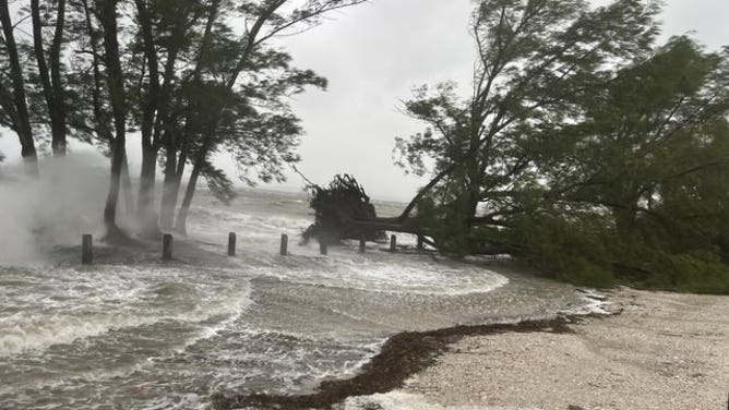
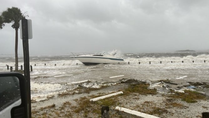
![Storm surge from Hurricane Helene in Bradenton, Florida]() Image 17 of 23
Image 17 of 23Storm surge from Hurricane Helene in Bradenton, Florida (Bradenton, Florida Police Department )
![Storm surge from Hurricane Helene in Bradenton, Florida]() Image 18 of 23
Image 18 of 23Storm surge from Hurricane Helene in Bradenton, Florida (Bradenton, Florida Police Department )
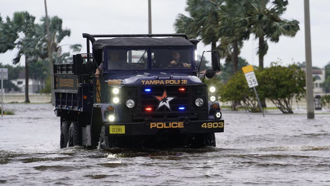
![Storm surge from Hurricane Helene in Tampa, Florida]() Image 19 of 23
Image 19 of 23Storm surge from Hurricane Helene in Tampa, Florida (Tampa Police Department)
![Storm surge from Hurricane Helene in Tampa, Florida]() Image 20 of 23
Image 20 of 23Storm surge from Hurricane Helene in Tampa, Florida (Tampa Police Department)
![Flooding in Lee County, Florida]() Image 21 of 23
Image 21 of 23Flooding in Lee County, Florida (Carmine Marceno, Lee County, Florida)
![Storm Surge flooding in Treasure Island, Florida from Hurricane Helene on Sept. 26, 2024.]() Image 22 of 23
Image 22 of 23Storm Surge flooding in Treasure Island, Florida from Hurricane Helene on Sept. 26, 2024. (City Of Treasure Island, Florida)
![Storm Surge flooding in Treasure Island, Florida from Hurricane Helene on Sept. 26, 2024.]() Image 23 of 23
Image 23 of 23Storm Surge flooding in Treasure Island, Florida from Hurricane Helene on Sept. 26, 2024. (City Of Treasure Island, Florida)


Water rescues along Florida's Gulf Coast
Deputies in Lee County were seen going from door-to-door in Fort Myers Beach looking for storm victims needing help.
A storm surge of more than 5 feet was reported which submerged roadways, forcing deputies to use boats for searches.
The Lee County Sheriff's Office deployed what is known as a swamp buggy in a neighborhood known as Margaritaville along Fort Myers Beach.
WHAT'S THE DIFFERENCE BETWEEN A TROPICAL DEPRESSION, TROPICAL STORM AND HURRICANE?
The Taylor County Sheriff’s Office in Florida's Big Bend asked residents who chose not to heed mandatory evacuation warnings for Hurricane Helene to write their name and other identifying information in permanent marker on their arms or legs.
"Phase 2 of the storm will be this evening when Helene makes landfall," FOX Weather Hurricane Specialist Byran Norcross said. "Based on everything we know, damage will be widespread around Tallahassee east and west and far north into Georgia. These are heavily treed communities that will not handle extreme winds. Power could be out for weeks."
During the hurricane, the Florida Highway Patrol reported responding to a serious crash along Interstate 4 with the possibility of one fatality.
In a Florida Department of Transportation video, a highway sign appeared to be dislodged and lying on a car.
Troopers have not revealed what they believe caused the crash but encouraged residents to simply stay home until the worst of the weather exits the region.

Deadly crash reported along Interstate 4 in Tampa.
(FDOT / FOX Weather)
WHERE DOES HELENE GO AFTER HITTING FLORIDA? SOUTHEAST, MID-ATLANTIC COULD SEE CATASTROPHIC FLOODING
Echoing the disaster of 2018's Hurricane Michael
Nearly the entire state of Florida is under some sort of tropical weather alert, with Tropical Storm Warnings extending hundreds of miles inland into Georgia and the Carolinas, including Atlanta.

Flooding hits downtown Naples as Hurricane Helene closes in
Storm surge led to severe flooding in downtown Naples, Florida, as Hurricane Helene moved closer to the state. Footage posted by X user @chuckbender66 shows conditions in the Tin City waterfront in Naples on Thursday morning.
WHAT TO DO WHEN HURRICANE OR TROPICAL STORM WATCHES AND WARNINGS ARE ISSUED FOR YOUR TOWN
NHC Director Dr. Michael Brennan joined FOX Weather on Thursday and urged residents to listen to officials and leave immediately if told to do so.
"The impacts of this storm are on an enormous scale and are going to extend over multiple states all the way up into the Carolinas and southern Appalachians – the storm surge, the hurricane and tropical storm force winds and the potential for catastrophic rainfall," Brennan said.
Brennan brought up Hurricane Michael in 2018 when talking about how deadly and dangerous a storm surge can be.
"When Hurricane Michael hit Mexico Beach in 2018, there were people who waited until that last minute, and people drowned in their cars trying to get away because the water comes up so fast that you cannot get out," Brennan noted. "That's why you should follow those evacuation orders you're given by your local officials and get out ahead of the storm. Much of these areas, you still have time, but that time is rapidly running out.
WHERE DOES HELENE GO AFTER HITTING FLORIDA? SOUTHEAST, MID-ATLANTIC COULD SEE CATASTROPHIC FLOODING

(FOX Weather)