Tropical Storm Idalia nearing hurricane strength, mandatory evacuations underway in Florida
Hurricane Warnings have been issued for Tampa Bay as Gov. Ron DeSantis and Florida officials urge all residents along the state's Gulf Coast to prepare for Idalia.
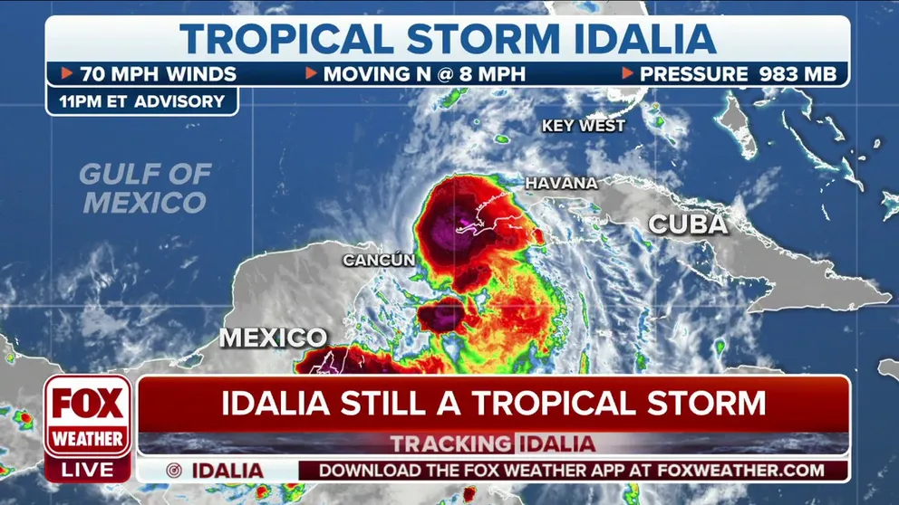
Idalia remains a tropical storm in Monday's last advisory
The NHC says there was no change between the 7 p.m. CT advisory and the 10 p.m. advisory. Idalia continues to linger near the western tip of Cuba.
As of Tuesday at 5:00 AM, Hurricane Idalia formed and is forecast to rapidly intensify into an ‘extremely dangerous major hurricane’ before Florida landfall. Continuous coverage has moved here.
Tropical Storm Idalia is intensifying and is forecast to become a major hurricane before it makes landfall along Florida’s Gulf Coast, blasting millions in the state with life-threatening storm surge and dangerous hurricane-force winds starting as early as Tuesday, according to the National Hurricane Center (NHC).
Hurricane, Tropical Storm and Storm Surge Watches and Warnings have been issued for most of Florida’s west coast as the state urges mandatory evacuations and finalizes preparations for Idalia’s landfall on Wednesday. Powerful hurricane-force winds up to 120 mph and catastrophic storm surge up to 7-9 feet are forecast for landfall. Dangerous flash flooding is also expected across Florida’s west coast, the Florida Panhandle and in southern Georgia.
"Rapid strengthening is predicted during the next day or so," said the NHC. "Idalia could become a hurricane at any time and is forecast to become a major hurricane by late Tuesday or Tuesday night."
Gov. Ron DeSantis held a news conference on Monday with other state leaders and said 46 counties are now included in a state of emergency. However, DeSantis stressed that even if a county is not included in the state of emergency, residents need to prepare for possible major impacts from Tropical Storm Idalia.

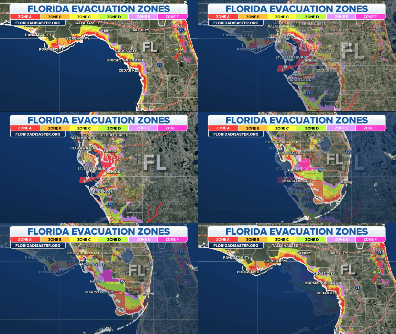
Florida evacuation zones.
(FOX Weather)
DOWNLOAD THE FREE FOX WEATHER APP
"Pretty much anybody on the west coast of Florida, I mean, you can see major, major impacts, so please prepare accordingly," he said.
President Joe Biden approved the state's emergency declaration to the federal government on Monday morning. The state’s Emergency Operations Center is now operating at Level 1, which means a 24-hour operation until the storm threat passes.
DeSantis said resources have been propositioned ahead of the storm, and more than 5,500 National Guard members are ready to respond in Florida. In addition, DeSantis said 650 Starlink dishes are ready to help with connectivity after the storm if needed.
"Buckle up for this one. It's going to be a major hurricane," he said.
Evacuations have already been ordered in 21 counties as of Monday night, and DeSantis is urging residents who are being told to evacuate to do so. Full evacuation orders are available here.
"Evacuation orders, I urge Floridians to heed the admonitions and heed the directives from your officials," DeSantis said. "There are going to be evacuations issued in all these Gulf Coast counties in the A zones. All the barrier islands, places that are low-lying on the coast. You are going to be told to evacuate."

(FOX Weather)
Florida Division of Emergency Management Executive Director Kevin Guthrie said storm surge was the number one cause of death during Hurricane Ian.
Tampa International Airport is set to close at 12:01 a.m. on Tuesday due to Idalia's impending landfall, as additional flight disruptions are expected in and out of Florida. St. Petersburg/Clearwater International Airport will close at 3 p.m.
Tampa Mayor Jane Castor issued an executive order on Monday declaring a state of emergency as a result of Tropical Storm Idalia, and the city of Jacksonville also declared a state of emergency that went into effect Monday morning.
Already 38 school districts have also announced that they will remain closed for at least the next few days. Ten state colleges and six universities canceled classes, too.
KNOW YOUR ZONE: FLORIDA EVACUATION MAP SHOWS WHO WILL HAVE TO LEAVE BEFORE A HURRICANE STRIKES
Where is Tropical Storm Idalia?

(FOX Weather)
As of the latest advisory from the NHC, Tropical Storm Idalia is located about 10 miles southwest of the western tip of Cuba and about 230 miles southwest of the Dry Tortugas. Tropical Storm Idalia has maximum sustained winds of 70 mph with some higher gusts. Idalia is moving north at 8 mph.
2023 ATLANTIC HURRICANE SEASON GUIDE: HERE'S WHAT TO KNOW ABOUT THIS YEAR'S STORMS
Where is Tropical Storm Idalia going next?

(FOX Weather)
The NHC said Tropical Storm Idalia will continue on its northward motion through Monday night, followed by a faster north-northeast motion on Tuesday and Wednesday. The NHC says that on the forecast track, the center of Idalia is forecast to pass near or over the western tip of Cuba on Monday night, over the extreme southeastern Gulf of Mexico by early Tuesday and then reach the Gulf Coast of Florida on Wednesday.
With the latest advisory, the NHC is forecasting 120 mph winds off the west coast of Florida by Wednesday morning.
FLORIDA HURRICANE THREAT LIVE TRACKER: FUTURE PATH, WATCHES AND WARNINGS, SPAGHETTI MODELS AND MORE
What watches and warnings for Tropical Storm Idalia are in effect?

(FOX Weather)
A Hurricane Warning is in effect for:
- The middle of Longboat Key northward to the Indian Pass, including Tampa Bay
A Hurricane Watch is in effect for:
- Englewood to the middle of Longboat Key
A Tropical Storm Warning is in effect for:
- Dry Tortugas, Florida
- Chokoloskee northward to the middle of Longboat Key
- West of the Indian Pass to Mexico Beach
A Tropical Storm Watch is in effect for:
- Lower Florida Keys west of the west end of the Seven Mile Bridge
- Sebastian Inlet, Florida, northward to the South Santee River, South Carolina

(FOX Weather)
A Storm Surge Warning is in effect for:
- Englewood northward to the Ochlockonee River, including Tampa Bay
- From west of Indian Pass to Mexico Beach
A Storm Surge Watch is in effect for:
- Chokoloskee northward to Englewood, including Charlotte Harbor
- Mouth of the St. Mary's River to the South Santee River, South Carolina
Rainfall and flooding impacts from Tropical Storm Idalia

(FOX Weather)
Portions of the west coast of Florida, the Florida Panhandle, southeastern Georgia and the eastern Carolinas can expect to see 4-8 inches of rain from Tuesday into Thursday. There will also be isolated higher totals of up to 12 inches of rain possible, primarily near where Tropical Storm Idalia makes landfall.
Because of the risk of torrential rain, there is a risk of flash and urban flooding, which could be locally significant across portions of the west coast of Florida, the Florida Panhandle and southeastern Georgia Tuesday into Wednesday and spreading into portions of the eastern Carolinas on Wednesday into Thursday.
Hurricane-force wind impacts from Tropical Storm Idalia

(FOX Weather)
Coastal residents along Florida's Gulf Coast are being urged to prepare for impacts from hurricane-force winds up to 115 mph.
Sustained winds of at least 39 mph are capable of downing small branches and damaging trees, which can impact power lines.
Once sustained winds reach at least 40 mph, local first responders and emergency management usually shut down access to bridges in an effort to keep high-profile vehicles safe.
The last tropical cyclone to make landfall in Florida was Hurricane Nicole in November. Nicole was a Category 1 cyclone that made landfall near Vero Beach, and the National Centers for Environmental Information estimated the damage from Nicole was around $1 billion.
