End of triple-dip La Nina in sight: What it could mean for spring severe weather season
The frequency of severe weather outbreaks is higher in the U.S. during a La Niña pattern versus neutral or El Niño conditions. The current La Niña has a high chance of running through February, which means the 2022-23 winter season will take place without a significant change in climate patterns.
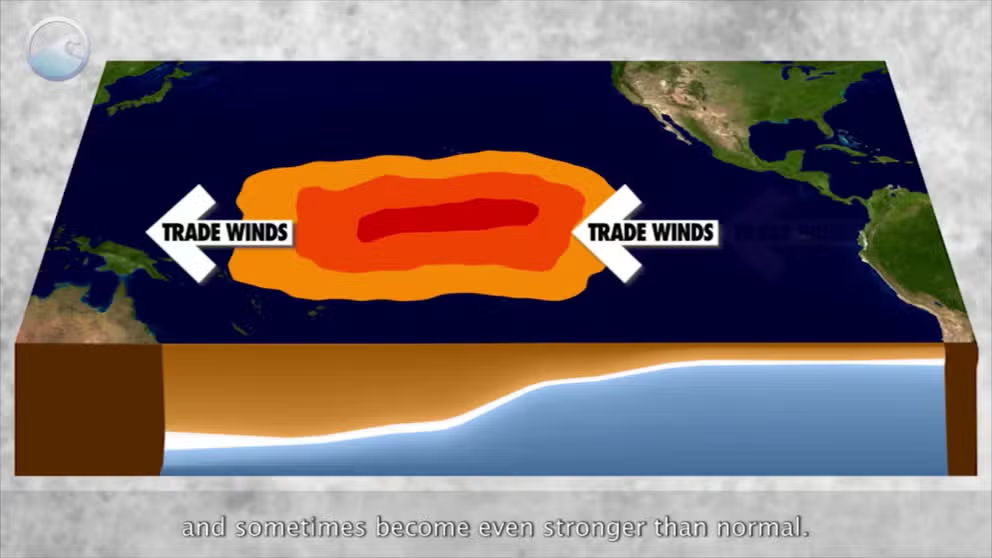
The meaning of El Nino and La Nina
The status of whether the world is being impacted by an El Nino or a La Nina is determined by water temperatures in the central and eastern Pacific. (NOAA)
The end of a rare triple-dip La Niña could occur during the upcoming spring, leading to weather changes around the globe.
Over the past three years, cooler than average water temperatures in the Pacific Ocean have led to consecutive La Niña years, but climate experts at the National Oceanic and Atmospheric Administration believe there is a 71 percent chance the status could switch to a neutral signal during the February through April time period.
Sea surface temperatures in critical parts of the eastern and central Pacific determine the status of the El Niño and the Southern Oscillation and whether a La Niña, El Niño or neutral conditions are in control.
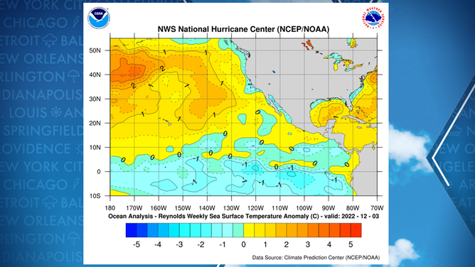
Water temperature anomalies in the Pacific
(NOAA)
A warming of the ocean in the central and eastern Pacific is expected to propel the ENSO status to jump from its current state of La Niña to a neutral status.
The neutral state is considered to in control when average water temperature anomalies are between 0.5 °C and -0.5 °C.
An extended period with readings above the 0.5 °C threshold sends the world into an El Niño, but forecasters believe seeing this type of weather pattern is not in the foreseeable future.
The changing of the climate patterns will not impact winter outlooks, as the season is already well underway, but the transition out of La Niña into neutral territory will mean changes in the weather across North America.
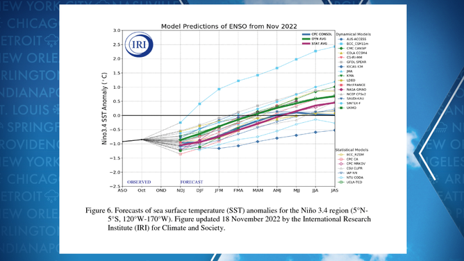
Computer forecasts for state of ENSO.
(NOAA)
La Niña winter is already underway
The current La Niña has a high chance of running through February, which means the 2022-23 winter season will take place without a significant change in climate patterns.
Forecasters expect the northern tier of the country to be colder and possibly snowier than normal, all while the South sees warmer-than-normal temperatures.
The FOX Weather Center said the contrast in temperatures and precipitation is fairly classic for a La Niña set-up.
So far, much of the southern U.S. has already seen mild temperatures, and the Pacific Northwest has been stuck in an unsettled weather pattern, which coincides with expectations.
Due to the warmer air that is typically present during these events, studies have found tornado outbreaks are more likely.
"Preliminary research indicates that La Niña corresponds to an especially active phase for tornadoes over the Deep South with a relatively high frequency of cold-season outbreaks of EF2 or stronger tornadoes," the National Weather Service office in Jackson, Mississippi, said.
But once the status flips from La Niña to neutral territory, there could be subtle changes in store for the country.
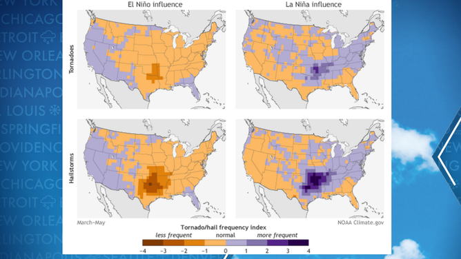
Where typical tornado activity occurs during El Nino and La Nina years.
(FOX Weather)
WHAT ARE EL NINO AND LA NINA CLIMATE PATTERNS?
ENSO-neutral conditions not known to produce busy spring severe weather seasons
As the atmosphere transitions out of a La Niña and tries to head towards an El Niño, the weather ingredients tend to be less prime for continuous severe weather outbreaks.
The spring season, which consists of the months of March, April and May, is typically the busiest period for severe weather as the jet stream allows plenty of warm moisture to stream northward and aid in the instability needed for thunderstorms.
Some storms can take advantage of vertical wind shear and become supercells with violent tornadoes.
Research completed by various private, government and educational groups has found that neutral-ENSO conditions tend to produce tornado and hail events that are more in line with average or slightly below-average historical tallies.
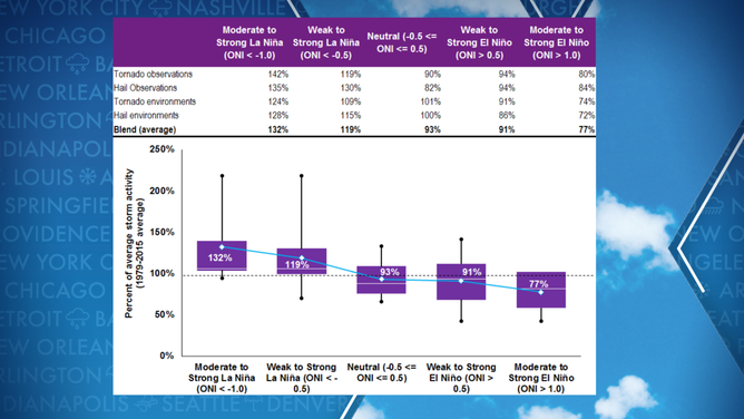
Hail and tornado activity versus state of atmosphere
(Willis Re/Columbia University / FOX Weather)
Some forecasters believe the ingredients typically aren't as conducive during a neutral event than during a La Niña period of the ENSO.
IT'S NOT YOUR GRANDPARENTS' TORNADO ALLEY ANYMORE
Experts stress there is tremendous variability, and not all neutral, La Niña or El Niño events follow historical trends.
The U.S. averages around 1,300 tornadoes each year, with many that either rank as an EF-0 and EF-1 on the Enhanced Fujita Scale.
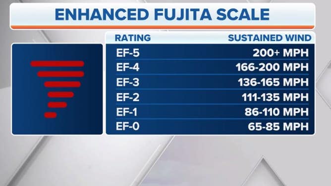
Tornadoes are rated from EF-0 to EF-5 on the Enhanced Fujita Scale.
(FOX Weather)
