Florida, Gulf Coast face torrential rain, flood threat from remnants of Tropical Storm Sara
Tropical Storm Sara was the eighteenth named storm to form during the 2024 Atlantic hurricane season. Significant flooding was reported in Honduras and Nicaragua as the storm system slowly trekked through the region.
Remnants of Tropical Storm Sara to bring heavy rain to Gulf Coast, Florida
The remnants of what was once Tropical Storm Sara are expected to be pulled to the north over the Gulf of Mexico and bring heavy rain to millions of people along the Gulf Coast and into Florida this week.
TALLAHASSEE, Fla. – Millions of people along the U.S. Gulf Coast from around New Orleans to the Florida Peninsula are facing a widespread rain event this week which stems from both a powerful storm system bringing severe weather to the Plains and the remnants of what was once Tropical Storm Sara.
According to the FOX Forecast Center, the cold front is expected to begin to move through the region late Monday through Wednesday, and could produce heavy precipitation and thunderstorms.

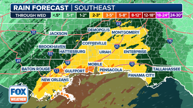
This graphic shows the forecast rain totals along the Gulf Coast.
(FOX Weather)
Computer forecast models suggest the heaviest rain will occur along the Interstate 10 corridor, where a widespread 2-3 inches of rain could fall, with locally higher amounts between 3-5 inches possible.
Cities such as New Orleans, Mobile, Alabama, and Pensacola, Florida, are all in the zone that could see the heaviest rainfall, while the rest of the Florida Peninsula is in store for lesser amounts.
Exact impacts will depend on how much moisture streams northward from the Caribbean and Gulf of Mexico associated with the tropical storm's remnants, but early indications suggest the slug of moisture will be fairly minimal when compared to previous Central American gyres and atmospheric river events.
DOWNLOAD THE FREE FOX WEATHER APP

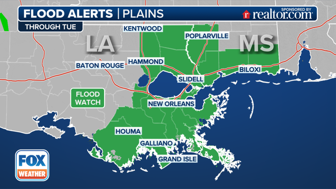
This graphic shows Flood Alerts in effect in the Southeast.
(FOX Weather)
The FOX Forecast Center says that the high rainfall rates could lead to flooding late Monday into Tuesday along the Gulf Coast, with the highest risk in southeastern Louisiana, southern Mississippi, Alabama, and the Florida Panhandle.
Some of the heaviest rain could fall overnight Monday into Tuesday, making travel especially dangerous as many drivers may not be able to see how deep water is when covering roadways.
Because of the threat, Flood Watches have been posted along the I-10 corridor from Louisiana to Mississippi, including cities like New Orleans, Houma, and Slidell in Louisiana and Biloxi in Mississippi.
WHAT TO DO IF YOUR HOUSE FLOODS?
Catastrophic flooding slams Honduras from Tropical Storm Sara
A combination of hostile upper-level winds, dry air and land interaction kept the 18th-named storm from ever becoming a hurricane but still led to catastrophic flooding in countries such as Honduras and Nicaragua.
Those countries are susceptible to flooding and natural disasters due to their terrain and socio-economic factors.

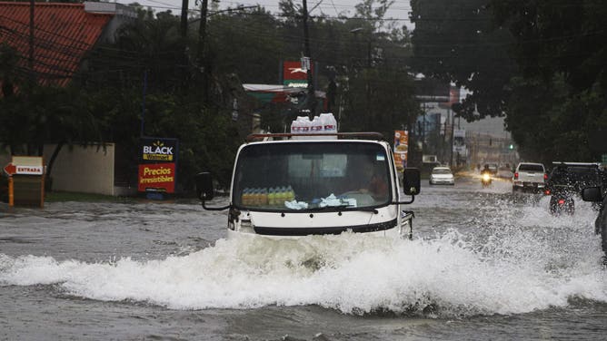
A truck drives through a flooded street during the passage of tropical storm Sara in La Ceiba, Honduras, on November 15, 2024. Honduras' President Xiomara Castro said emergency services had been activated to deal with "damage already caused by the rains," warning that Sara's impacts "could become a catastrophic event." (Photo by ESAU OCAMPO / AFP) (Photo by ESAU OCAMPO/AFP via Getty Images)
(Getty Images)
In 2020, aid groups estimated more than a quarter of a million residents were displaced after Hurricanes Eta and Iota, and in 1998, more than 11,000 were killed during the impacts of Hurricane Mitch.
Some of the same wording used by meteorologists to warn the Appalachians ahead of Hurricane Helene was used to alert Central American residents of the dangers that existed from Sara.
"There is a big history in Honduras of deadly floods. I was down there actually after Hurricane Mitch, and it was one of the most tragic things I’ve ever seen in my life," FOX Weather Hurricane Specialist Bryan Norcross said. "Whole hillsides coming down and just wiping out homes and homes, falling off of hillsides while families were in them. It happens in Honduras where there’s very mountainous areas. And, of course, economically, a lot of people were very distressed there. So all expectations are that this is going to be very bad in Honduras."
