Hurricane Watch issued in Florida as Tropical Depression 4 expected to strengthen into Debby
The Big Bend region of Florida is under a Hurricane Watch as Tropical Depression 4 inches into the Gulf of Mexico. Flooding rain, storm surge and high winds are likely starting late Saturday through the weekend.

Tropical Depression 4 starts to move into Gulf as warnings issued for portions of Florida Keys
A Hurricane Watch has been issued Saturday for a portion of the Florida Gulf coast as Tropical Depression Four is set to bring several inches of rain, strong winds and a possible life-threatening storm surge.
As of Saturday at 5:00 P.M., Tropical Depression Four strengthened into Tropical Storm Debby. Continuous coverage of Tropical Storm Debby has moved here.
MIAMI – A Hurricane Watch has been issued Saturday for a portion of the Florida Gulf coast as Tropical Depression Four is set to bring several inches of rain, strong winds and a possible life-threatening storm surge.
Most of the state remains under a state of emergency, and administrators urge people to prepare before the weather deteriorates during the second half of the weekend.
TRACK THE TROPICS: FORECAST CONE, LIVE CONDITIONS, SPAGHETTI MODELS AND MORE

Watch: Ominous skies seen over waters of Fort Myers Beach as storm approaches
Florida is preparing for tropical impacts. The latest advisory predicts that Debby will form sometime Saturday and make landfall on Monday morning in Florida's Big Bend, close to where Hurricane Idalia made its historic landfall as a Category 3 hurricane last year. Ominous skies were seen over waters of Fort Myers Beach on Saturday afternoon as the storm approaches.
National Hurricane Center Director Michael Brennan told FOX Weather on Saturday that this will be a multi-hazard event.
"The biggest hazards are usually the water, and we're expecting widespread heavy rainfall – 5-10 inches across much of Florida up into the coastal southeast U.S. (with) isolated total size of 15 inches," he said. "So certainly substantial risk for freshwater flooding and also the potential for storm surge."

NHC director: Storm surge flooding expected along Florida's west coast from tropical storm
The state of Florida has Tropical Storm Watches and Warnings in effect for parts of the state. Director of the National Hurricane Center, Michael Brennan, joins FOX Weather as Tropical Depression Four makes headlines, as the storm is expected to strengthen into Tropical Storm Debby, perhaps by Saturday evening.
Tropical downpours and gusty winds have already started to spread north across the Sunshine State and are expected to continue through Saturday.
The FOX Forecast Center expects this disturbance to strengthen into a tropical storm over the eastern Gulf of Mexico and move northeast toward Florida's Gulf Coast during the next 36 hours. Once it organizes and winds reach 40 mph, it will be named Debby.

Florida racing to prep ahead of tropical trouble this weekend
The race is on in Florida to prepare for likely Tropical Storm Debby's impact. The state's governor has already declared a state of emergency, as time is running out. FOX Weather Storm Specialist Mike Seidel is standing by in North Redington Beach, Florida, with the latest updates on the weather conditions in the Sunshine State.
The storm is tracking farther west than earlier forecasts, which pushes back the time of landfall until Monday morning, somewhere along Florida's Big Bend region, the NHC noted.
If the storm hugs the coast, it could make landfall earlier, but if it stays out over the warm waters of the Gulf, then it could undergo further strengthening, and it remains a possibility that the storm reaches hurricane strength before making landfall.
Regardless of name or strength, the storm will drop heavy rain across Florida and trigger flash flooding in flood-prone areas.
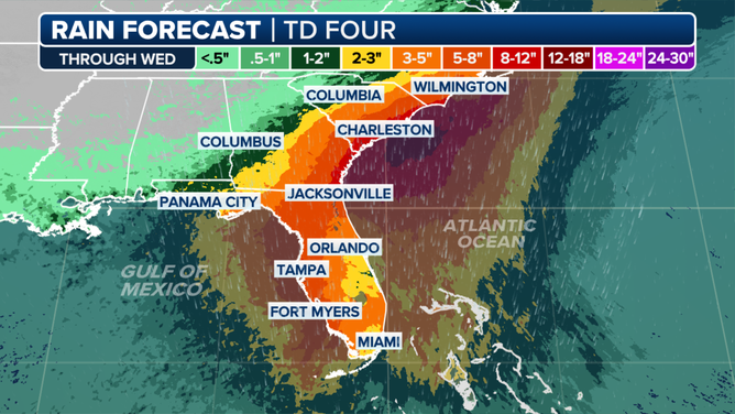
Here's a rain outlook through Wednesday of next week.
(FOX Weather)
Gusty winds are also a concern, especially along the Gulf Coast. Gusts of 50-70 mph should be expected as the storm makes landfall.
After landfall, the storm's forward speed will slow to a crawl, bringing an extended period of rain, wind and potential coastal flooding that could persist into next week.

Bryan Norcross provides update on Tropical Depression Four
FOX Weather Hurricane Specialist Bryan Norcross covers the latest advisory about Tropical Depression Four, which is expected to develop and become Tropical Storm Debby later today or tonight. Aug. 3, 2024.
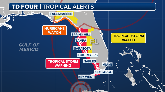
Who is under tropical storm alerts?
A Hurricane Watch is now in effect for the Florida coast west of the Aucilla River to Indian Pass, indicating hurricane-force winds of more than 74 mph are possible within 48 hours.
A Tropical Storm Warning is currently in effect for the Florida Keys west of the Seven Mile Bridge, including the Dry Tortugas, as well as the west coast of the Florida peninsula from south of Yankeetown to East Cape Sable.
Additionally, a Tropical Storm Watch has been issued for the Florida Keys south of the Channel 5 Bridge.
In terms of Storm Surge Warnings, Aripeka northward to the Aucilla River is under threat, while a Storm Surge Watch is in effect for Bonita Beach northward to Aripeka, including Tampa Bay and Charlotte Harbor, as well as west of the Aucilla River to Indian Pass.
TRACK POTENTIAL TROPICAL CYCLONE 4: FORECAST CONE, LIVE CONDITIONS, SPAGHETTI MODELS AND MORE
Alerts have been issued along the Florida Gulf Coast on Aug. 3, 2024, as Tropical Depression 4 strengthens.
(FOX Weather)
WHAT IS A POTENTIAL TROPICAL CYCLONE?
The NHC noted that while their latest forecast cone issued Saturday morning does not explicitly show the storm reaching hurricane strength, the storm may undergo additional strengthening just before landfall Monday.
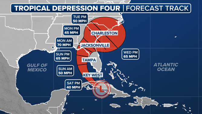
A look at the forecast track for TD 4.
(FOX Weather)
Feet of storm surge possible along Florida's west coast
Tropical storm-force winds are expected in the warned areas across southwestern Florida late Saturday into Saturday night, moving up the west coast of Florida into Sunday.
Storm surge of 2-5 feet is possible along portions of Florida's west coast, with the highest surge expected along the Big Bend area, and up to 4 feet in Tampa Bay and Charlotte Harbor, the NHC warned.

Here's a look at the expected storm surge.
(FOX Weather)
A Flood Watch is in effect for all of South Florida, including Miami, effective through Sunday evening.
Where does the storm go after landfall?
There still remains great uncertainty about the fate of the storm once it makes landfall Monday. Weakening steering currents will cause the storm to slow down over northern Florida, and from there, forecast model guidance becomes split.
Forecasts show a very slow motion between Monday and Thursday, Brennan said.
"We have the storm sort of crawling along the southeast coast, whether it's inland or just offshore, will have a big difference in how strong it gets from a wind perspective," he added.
What Brennan is most concerned about is the rainfall.
"We could see really heavy rainfall totals along portions of the coastal Southeast, places like Savannah, Hilton Head, Charleston and up to southern North Carolina," he said.
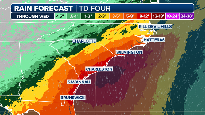
Here's a rain outlook through Wednesday of next week.
(FOX Weather)
The flash flooding risk Monday stretches from Jacksonville, Florida, up to Myrtle Beach, South Carolina. These areas are in a Level 3 out of 4 risk zone for flash flooding.
"This is the area of greatest concern where we can see that really heavy rainfall unfold," Brennan said.