Massive plume of Saharan dust keeps tropics in check for now
NOAA says the air surrounding a dust plume has 50% less moisture than the typical atmosphere, which means the presence of the Saharan Air Layer can be detrimental to cloud formation and thunderstorm activity.
Massive plume of Saharan dust keeps tropics in check for now
The largest outbreak of Saharan dust so far this summer is moving over the Atlantic, putting a cap on tropical development and threatening to impact air quality throughout the Caribbean.
MIAMI – The largest outbreak of Saharan dust so far this summer is moving over the Atlantic, putting a cap on tropical development and threatening to impact air quality throughout the Caribbean.
Dust across the Atlantic’s Main Development Region (MDR) has been running below average, but that hasn’t prevented other locales around the African continent from exhibiting their worst impacts in memory.
During the spring, major cities across Europe such as Rome, Paris, Athens and Kyiv all reported reduced visibilities and poor air quality as plumes traveled northward from the African deserts.
Now that weather patterns have shifted to summer mode, dust that previously followed a more northerly trajectory during the cooler months is now heading westward into the Atlantic Basin.

(FOX Weather)
SKIES OF GREECE TURN EERIE RED AS AFRICAN DUST STORM MOVES THROUGH
According to NOAA, the air surrounding a Saharan Air Layer (SAL) has about 50% less moisture than the typical atmosphere, which means the presence of the SAL can be detrimental to cloud formation and thunderstorm activity.
Significant plumes of dust and dry air are common in the Atlantic during the first two and a half months of the hurricane season and help to limit cyclone formation.
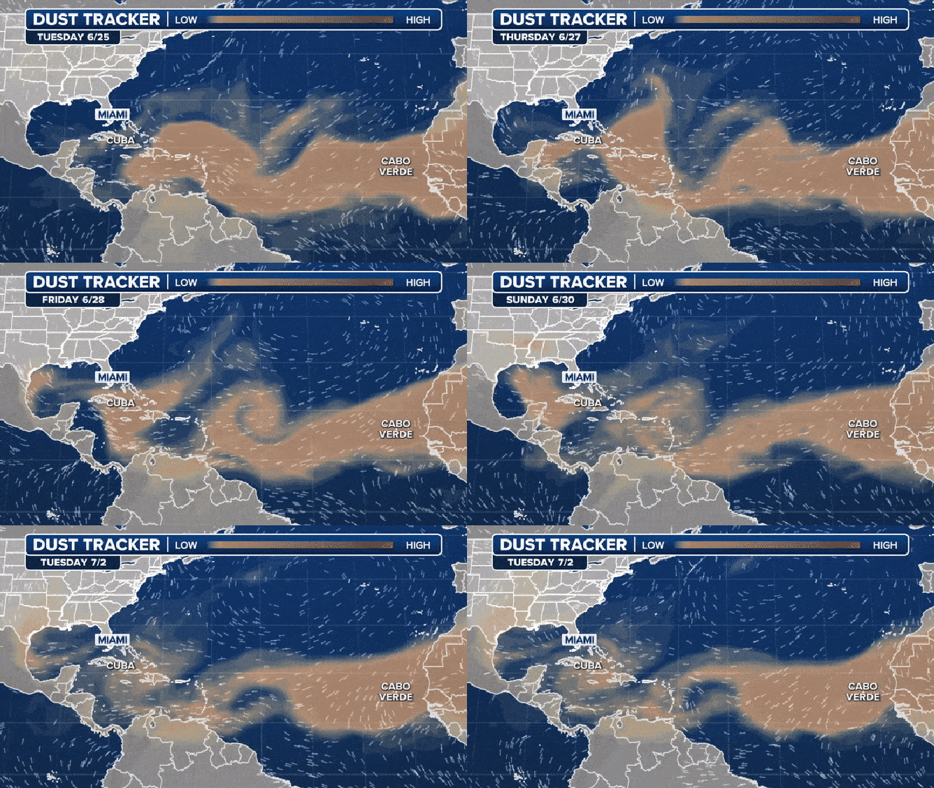
The latest outbreak is likely to hold any disturbances throughout the MDR in check for at least a week, if not longer.
Disturbances spawned by the Central American Gyre, such as Tropical Storm Alberto and Invest 93L, were far enough west in the basin not to see impacts from the dust.

The Saharan dust tracker.
(FOX Weather)
5 THINGS TO KNOW ABOUT THE SAHARAN DUST PLUME
It remains to be seen whether the SAL will have staying power to reach the Lower 48, but early indications from models from NASA and the European Union’s Copernicus program show this round of aerosols may not make it across the entire basin.
Coastal communities along the Florida Peninsula and the Gulf Coast are accustomed to seeing plumes of Saharan dust over the summer, which can impact air quality, produce colorful sunrises and sunsets and reduce chances of precipitation.
Islands in the Caribbean have a better chance of seeing impacts, as enough of the dust will make it near the surface.
According to medical experts at WebMD, eye, nose and throat irritations are possible when the fine dust particles reach lower elevations.

(FOX Weather)
