North Carolina clobbered with historic rain as potent non-tropical storm moved onshore
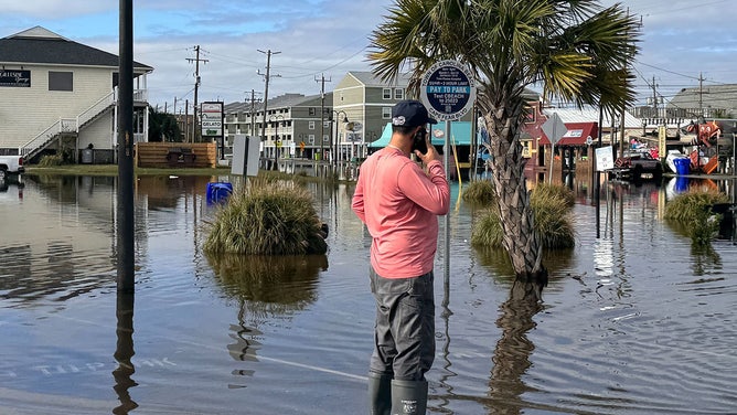
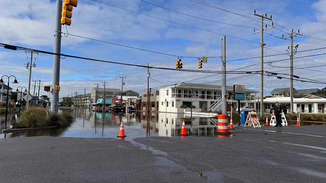
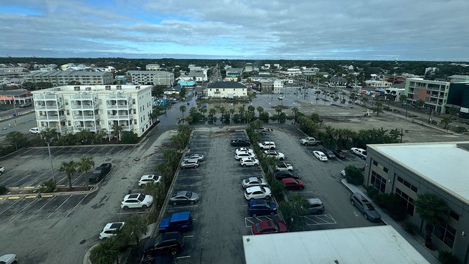
The coastal region was inundated with historic rainfall Monday, with places like Carolina Beach receiving upwards of 20 inches. This extreme precipitation, a once-in-a-thousand-year event, led to widespread and damaging flooding.

Coastal storm dumps upwards of 20 inches of rain in Carolina Beach, NC
Despite never receiving an official name, the storm that was once known as Potential Tropical Cyclone Eight has left its mark on southeastern North Carolina.
WILMINGTON, N.C. – Despite never receiving an official name, the storm that was once known as Potential Tropical Cyclone Eight has left its mark on southeastern North Carolina.

Watch: Flooding inundates Carolina Beach, North Carolina
A view from above shows flooding across Carolina Beach. The town has received more than 18 inches of rain since midnight on Monday.
The coastal region was inundated with historic rainfall Monday, with places like Carolina Beach receiving upwards of 20 inches. This extreme precipitation, a once-in-a-thousand-year event, led to widespread and damaging flooding.
![On Tuesday morning, residents and volunteers came together to clean up Carolina Beach, North Carolina, after the damage caused by Monday's storms.]() Image 1 of 17
Image 1 of 17On Tuesday morning, residents and volunteers came together to clean up Carolina Beach, North Carolina, after the damage caused by Monday's storms. (Brandy Campbell)
![On Tuesday morning, residents and volunteers came together to clean up Carolina Beach, North Carolina, after the damage caused by Monday's storms.]() Image 2 of 17
Image 2 of 17On Tuesday morning, residents and volunteers came together to clean up Carolina Beach, North Carolina, after the damage caused by Monday's storms. (Brandy Campbell)
![On Tuesday morning, residents and volunteers came together to clean up Carolina Beach, North Carolina, after the damage caused by Monday's storms.]() Image 3 of 17
Image 3 of 17On Tuesday morning, residents and volunteers came together to clean up Carolina Beach, North Carolina, after the damage caused by Monday's storms. (Brandy Campbell)
![On Tuesday morning, residents and volunteers came together to clean up Carolina Beach, North Carolina, after the damage caused by Monday's storms.]() Image 4 of 17
Image 4 of 17On Tuesday morning, residents and volunteers came together to clean up Carolina Beach, North Carolina, after the damage caused by Monday's storms. (Brandy Campbell)
![On Tuesday morning, residents and volunteers came together to clean up Carolina Beach, North Carolina, after the damage caused by Monday's storms.]() Image 5 of 17
Image 5 of 17On Tuesday morning, residents and volunteers came together to clean up Carolina Beach, North Carolina, after the damage caused by Monday's storms. (Brandy Campbell)
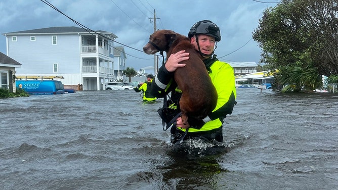
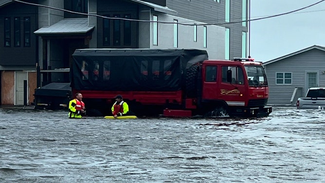
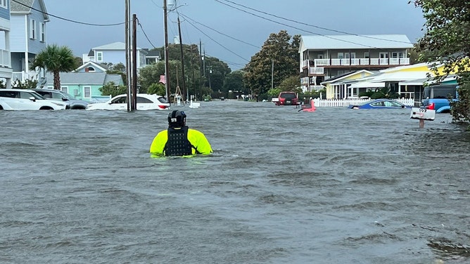
![The Wilmington Fire Department said their crews on their high-water rescue vehicle were hard at work in Carolina Beach and Kure Beach on Monday.]() Image 6 of 17
Image 6 of 17The Wilmington Fire Department said their crews on their high-water rescue vehicle were hard at work in Carolina Beach and Kure Beach on Monday. (Wilmington, NC Fire Department)
![The Wilmington Fire Department said their crews on their high-water rescue vehicle were hard at work in Carolina Beach and Kure Beach on Monday.]() Image 7 of 17
Image 7 of 17The Wilmington Fire Department said their crews on their high-water rescue vehicle were hard at work in Carolina Beach and Kure Beach on Monday. (Wilmington, NC Fire Department)
![The Wilmington Fire Department said their crews on their high-water rescue vehicle were hard at work in Carolina Beach and Kure Beach on Monday.]() Image 8 of 17
Image 8 of 17The Wilmington Fire Department said their crews on their high-water rescue vehicle were hard at work in Carolina Beach and Kure Beach on Monday. (Wilmington, NC Fire Department)
![Beachgoers should avoid the ocean over the next few days as Potential Tropical Cyclone Eight creates extremely dangerous surf conditions from Georgia to Virginia. The Carolina shore, including Kure Beach, is at risk of life-threatening rip currents and waves exceeding 10 feet.]() Image 9 of 17
Image 9 of 17Beachgoers should avoid the ocean over the next few days as Potential Tropical Cyclone Eight creates extremely dangerous surf conditions from Georgia to Virginia. The Carolina shore, including Kure Beach, is at risk of life-threatening rip currents and waves exceeding 10 feet. (Brandy Campbell)
![Beachgoers should avoid the ocean over the next few days as Potential Tropical Cyclone Eight creates extremely dangerous surf conditions from Georgia to Virginia. The Carolina shore, including Kure Beach, is at risk of life-threatening rip currents and waves exceeding 10 feet.]() Image 10 of 17
Image 10 of 17Beachgoers should avoid the ocean over the next few days as Potential Tropical Cyclone Eight creates extremely dangerous surf conditions from Georgia to Virginia. The Carolina shore, including Kure Beach, is at risk of life-threatening rip currents and waves exceeding 10 feet. (Brandy Campbell)
![Beachgoers should avoid the ocean over the next few days as Potential Tropical Cyclone Eight creates extremely dangerous surf conditions from Georgia to Virginia. The Carolina shore, including Kure Beach, is at risk of life-threatening rip currents and waves exceeding 10 feet.]() Image 11 of 17
Image 11 of 17Beachgoers should avoid the ocean over the next few days as Potential Tropical Cyclone Eight creates extremely dangerous surf conditions from Georgia to Virginia. The Carolina shore, including Kure Beach, is at risk of life-threatening rip currents and waves exceeding 10 feet. (Brandy Campbell)
![Beachgoers should avoid the ocean over the next few days as Potential Tropical Cyclone Eight creates extremely dangerous surf conditions from Georgia to Virginia. The Carolina shore, including Kure Beach, is at risk of life-threatening rip currents and waves exceeding 10 feet.]() Image 12 of 17
Image 12 of 17Beachgoers should avoid the ocean over the next few days as Potential Tropical Cyclone Eight creates extremely dangerous surf conditions from Georgia to Virginia. The Carolina shore, including Kure Beach, is at risk of life-threatening rip currents and waves exceeding 10 feet. (Brandy Campbell)
![Beachgoers should avoid the ocean over the next few days as Potential Tropical Cyclone Eight creates extremely dangerous surf conditions from Georgia to Virginia. The Carolina shore, including Kure Beach, is at risk of life-threatening rip currents and waves exceeding 10 feet.]() Image 13 of 17
Image 13 of 17Beachgoers should avoid the ocean over the next few days as Potential Tropical Cyclone Eight creates extremely dangerous surf conditions from Georgia to Virginia. The Carolina shore, including Kure Beach, is at risk of life-threatening rip currents and waves exceeding 10 feet. (Brandy Campbell)
![Beachgoers should avoid the ocean over the next few days as Potential Tropical Cyclone Eight creates extremely dangerous surf conditions from Georgia to Virginia. The Carolina shore, including Kure Beach, is at risk of life-threatening rip currents and waves exceeding 10 feet.]() Image 14 of 17
Image 14 of 17Beachgoers should avoid the ocean over the next few days as Potential Tropical Cyclone Eight creates extremely dangerous surf conditions from Georgia to Virginia. The Carolina shore, including Kure Beach, is at risk of life-threatening rip currents and waves exceeding 10 feet. (Brandy Campbell)
![Beachgoers should avoid the ocean over the next few days as Potential Tropical Cyclone Eight creates extremely dangerous surf conditions from Georgia to Virginia. The Carolina shore, including Kure Beach, is at risk of life-threatening rip currents and waves exceeding 10 feet.]() Image 15 of 17
Image 15 of 17Beachgoers should avoid the ocean over the next few days as Potential Tropical Cyclone Eight creates extremely dangerous surf conditions from Georgia to Virginia. The Carolina shore, including Kure Beach, is at risk of life-threatening rip currents and waves exceeding 10 feet. (Brandy Campbell)
![Beachgoers should avoid the ocean over the next few days as Potential Tropical Cyclone Eight creates extremely dangerous surf conditions from Georgia to Virginia. The Carolina shore, including Kure Beach, is at risk of life-threatening rip currents and waves exceeding 10 feet.]() Image 16 of 17
Image 16 of 17Beachgoers should avoid the ocean over the next few days as Potential Tropical Cyclone Eight creates extremely dangerous surf conditions from Georgia to Virginia. The Carolina shore, including Kure Beach, is at risk of life-threatening rip currents and waves exceeding 10 feet. (Brandy Campbell)
![Beachgoers should avoid the ocean over the next few days as Potential Tropical Cyclone Eight creates extremely dangerous surf conditions from Georgia to Virginia. The Carolina shore, including Kure Beach, is at risk of life-threatening rip currents and waves exceeding 10 feet.]() Image 17 of 17
Image 17 of 17Beachgoers should avoid the ocean over the next few days as Potential Tropical Cyclone Eight creates extremely dangerous surf conditions from Georgia to Virginia. The Carolina shore, including Kure Beach, is at risk of life-threatening rip currents and waves exceeding 10 feet. (Brandy Campbell)


The system made landfall in South Carolina on Monday evening before continuing inland and gradually weakening. The low-pressure area is expected to dissipate over the Carolinas on Wednesday, according to the FOX Forecast Center.
WATCH: CAROLINA BEACH FLOODED AS NORTH CAROLINA GETS HAMMERED BY POTENTIAL TROPICAL CYCLONE 8

(FOX Weather)
As the storm moved onshore, Tropical Storm Warnings were lifted, but Flash Flood Warnings and Flood Watches remain in effect for portions of southeastern Virginia and North Carolina.
The storm unleashed a deluge upon Carolina Beach and Kure Beach, with rain falling so heavily it felt like a firehose. Karly Wilson captured a video showing the conditions around her home in Carolina Beach on Tuesday morning.
"We were not able to go out front but could make it out back and just walked to the beach for some coffee and breakfast," she said Tuesday.
GRASSHOPPER JOINS BOB VAN DILLEN FOR UPDATES ON FLOODING IN WINNABOW, NORTH CAROLINA

Floodwater remains in Carolina Beach, NC following historic rainfall
Floodwaters remained in parts of coastal North Carolina on Tuesday following a historic amount of rain the day before. Footage by Karly Wilson shows conditions around her home in Carolina Beach on Tuesday morning.
Footage filmed Monday by Eitan Feldstein, who was sailing from Cape Canaveral to Chesapeake Bay before getting stuck in the storm at Carolina Beach, showed the ferocity of the storm.
"We just happened to get caught in this, unfortunately," Feldstein said. "(Sunday), we pulled into Carolina Beach and tied up to a mooring ball. We were the only boat not docked, but we took comfort knowing no boats would break free and smash into us. The storm was much stronger than we expected."
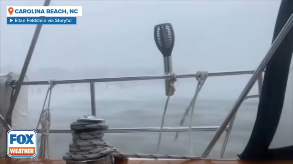
Daredevil boater records 'historic' storm lashing North Carolina coast
Strong wind and rain battered parts of coastal North Carolina on Monday as a historic 18 inches of rain fell over a span of 12 hours, according to the National Weather Service. This footage was filmed by Eitan Feldstein on Monday, who said he was sailing from Cape Canaveral to Chesapeake Bay before getting stuck in the storm at Carolina Beach since Sunday.
The storm's impact was severe in the small coastal town, resulting in widespread flooding. Emergency services were inundated with calls for assistance as residents were trapped due to rising water levels. Vehicles were stranded along Canal Drive as a Flash Flood Warning remained in effect until 8:45 p.m. ET Monday.
"Folks, do not go out," said Carolina Beach Mayor Lynn Barbee after issuing a state of emergency for the coastal town.
Resident Ed Alexander described the storm's flooding as the worst he had seen in the area since Hurricane Florence in 2018.
"It's a mess for sure," he told FOX Weather. "I don't think anyone was ready for this … that's living by the ocean. This is what to expect."

Carolina Beach, NC overwhelmed by floodwaters as state of emergency issued
Powerful winds and heavy rainfall are causing havoc across parts of southeastern North Carolina on Monday as Potential Tropical Cyclone Eight approaches the coast of South Carolina. FOX Weather Meteorologist and Storm Specialist Mike Seidel is live from Carolina Beach, North Carolina.
The storm's fury was also evident in nearby Sunny Point, North Carolina, where wind gusts reached 77 mph. The relentless assault on the North Carolina coast led to waves as high as 10 feet, eroding the beaches.

Potential Tropical Cyclone 8 lashes Carolina coast with heavy rain, wind
Powerful winds and heavy rainfall are sweeping across parts of southeastern North Carolina on Monday as Potential Tropical Cyclone Eight nears landfall and could soon become Tropical Storm Helene.
As storm surge inundated North Carolina's coastal communities, the relentless pounding of waves eroded Wrightsville Beach. The video below captured the moment when sand collapsed into the raging surf.

Severe beach erosion evident in Wrightsville Beach, North Carolina following Monday's storms
The sheer force of a non-tropical storm devastated North Carolina's coastline on Monday. In Wrightsville Beach, the relentless assault of waves eroded the beach, as video captures sand collapsing into the sea.
Where it is headed next
The coastal low will continue to slowly move north across the Carolinas towards the mid-Atlantic over the next day or so.
DOWNPOURS TARGET I-95 CORRIDOR IN MID-ATLANTIC WITH FLASH FLOOD THREAT TUESDAY

(FOX Weather)
Moist, onshore winds will support persistent showers and thunderstorms across portions of North Carolina and the southern mid-Atlantic on Tuesday. Locally heavy rainfall could result in some instances of flash flooding.

(FOX Weather)