Helene rapidly organizing as millions in Florida prepare for landfall of major hurricane
Tropical Storm Helene is expected to strengthen into a major hurricane before making landfall on Florida's Gulf Coast or Big Bend region later this week. Storm Surge and Hurricane Warnings are in place for Florida's Gulf Coast.

Helene rapidly organizing, remains on track to become major hurricane on approach to Florida
Tropical Storm Helene is rapidly organizing and is expected to become a major hurricane as it approaches Florida as residents rush to finish preparing for a potentially deadly storm surge, destructive hurricane-force winds and flooding rain.
UPDATE: Tropical Storm Helene strengthened into a hurricane on Wednesday, Sept. 25. Follow the latest FOX Weather coverage and forecast for Hurricane Helene by clicking here.
– Previous story –
TAMPA, Fla. – Tropical Storm Helene is rapidly organizing Wednesday and is expected to become a major hurricane as it approaches Florida while residents rush to finish preparing for a potentially deadly storm surge, destructive hurricane-force winds and flooding rain.
The National Hurricane Center (NHC) said there is danger of a life-threatening storm surge along the entire west coast of the Florida Peninsula and Big Bend.
As the storm comes ashore late Thursday, the Big Bend area is expected to experience the highest water levels – as much as 15 feet above dry land. Tampa Bay could see 5-8 feet of storm surge inundation under current forecasts.
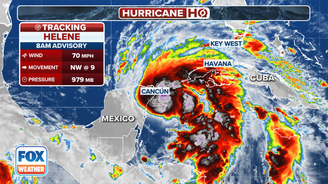
The latest information on Tropical Storm Helene.
(FOX Weather)
Mandatory evacuation orders are in effect for swaths of Florida's Gulf Coast, from the Panhandle, across the Big Bend and into Southwest Florida. This includes portions of Hillsborough County, which is where Tampa is located, for Zone A.
Florida Gov. Ron DeSantis issued an executive order Tuesday declaring a state of emergency for 61 of the state’s 67 counties to help agencies prepare for the incoming storm.
What is the forecast for Tropical Storm Helene?
According to the NHC's Wednesday morning update, Helene's maximum sustained winds have ramped up to at least 70 mph with higher gusts. The system is moving northwest, and that general motion is expected through Wednesday morning. It will be followed by a turn to the north starting later Wednesday.
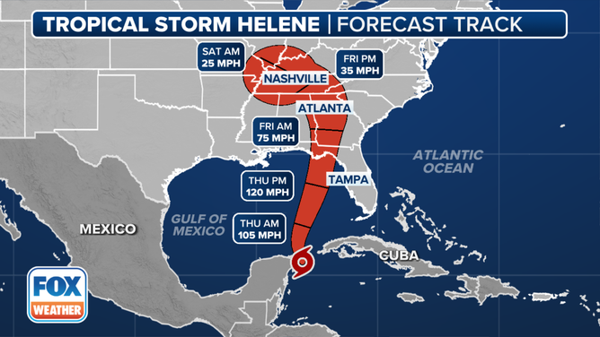
This graphic shows the forecast track for Tropical Storm Helene.
(FOX Weather)
Helene is expected to rapidly intensify into a major hurricane, meaning winds of at least 111 mph, as it moves over the eastern Gulf of Mexico and approaches the northeastern Gulf Coast on Thursday. The current 120-mph peak intensity forecast would rate the storm a Category 3 hurricane on the Saffir-Simpson Scale.
A Hurricane Warning has been issued from Anclote River to Mexico Beach, Florida, where damaging hurricane-force winds are expected later Thursday. The NHC is urging those in the warning areas to complete any preparations by early Thursday morning.
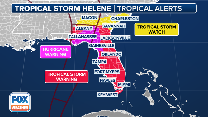
Current tropical alerts in effect for Tropical Storm Helene.
(FOX Weather)
Tropical Storm Warnings are in effect for all the Florida Keys, Dry Tortugas and the west coast of Florida from Flamingo to Anclote River, including Tampa Bay. West of Mexico Beach to the Walton/Bay County line, the east coast of Florida from Flamingo northward to the mouth of the St. Mary's River, and Lake Okeechobee.
Helene is expected to be a large hurricane in size – perhaps ranking among the 90% percentile among typical hurricanes of the area, according to the NHC.
"Therefore, storm surge, wind, and rainfall impacts will likely extend well away from the center and outside the forecast cone, particularly on the east side," NHC forecasters said Tuesday.
WHAT TO DO WHEN HURRICANE OR TROPICAL STORM WATCHES AND WARNINGS ARE ISSUED FOR YOUR TOWN

Time to prepare running out as Helene heads for Florida
Tropical Storm Helene is expected to become a major hurricane on approach to Florida, and that has the state on high alert. FOX Weather Meteorologist Michael Estime is in Tampa where residents are rushing to finish up preparations ahead of Helene.
National Hurricane Center Deputy Director Jamie Rhome said Helene will be unique for its large size and the intensification it's expected to undergo over the next 24 hours.
"A lot of people wrongly use the current intensity, how it looks currently in satellite imagery, as their overall indicator of risk, not what the storm will be when it moves ashore or moves into their community, but how it looks right now," Rhome told FOX Weather.
Storm surge, flooding a major concern
With the large storm size and track, a life-threatening storm surge is possible. Water could reach 10-15 feet above dry level if the surge comes in at high tide between the Ochlockonee River and Chassahowitzka along Florida's Big Bend, according to the NHC. A storm surge of varying heights is expected all along the entire west coast of Florida, with higher levels expected the closer you get to Helene's eventual landfall.

The storm surge forecast for the Gulf Coast of Florida.
(FOX Weather)
WHAT'S THE DIFFERENCE BETWEEN A TROPICAL DEPRESSION, TROPICAL STORM AND HURRICANE?
Torrential rains from Helene will bring "considerable" flash and urban flooding across the Southeast, according to the NHC, with accumulations of 4 to 8 inches and isolated totals of about 12 inches. Significant river flooding is also a risk.
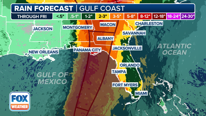
The rainfall forecast for the Southeast because of Tropical Storm Helene.
(FOX Weather)
Helene impacts could reach far inland
As future Hurricane Helene sets its sights on Florida, residents have been busy preparing for the storm as state and local officials begin to issue mandatory evacuation orders and declare states of emergency.
WATCH: HURRICANE ERNESTO’S SWELL CAUSES NORTH CAROLINA HOUSE TO COLLAPSE INTO OCEAN
![TALLAHASSEE, FLORIDA - SEPTEMBER 25: Kyley Weems bags sand in preparation for possible flooding on September 25, 2024 in Tallahassee, Florida. Forecasts predict Tropical Storm Helene will strengthen to a hurricane, making landfall along the Florida Gulf Coast on Thursday. (Photo by Sean Rayford/Getty Images)]() Image 1 of 13
Image 1 of 13TALLAHASSEE, FLORIDA - SEPTEMBER 25: Kyley Weems bags sand in preparation for possible flooding on September 25, 2024 in Tallahassee, Florida. Forecasts predict Tropical Storm Helene will strengthen to a hurricane, making landfall along the Florida Gulf Coast on Thursday. (Photo by Sean Rayford/Getty Images) ( )
![TALLAHASSEE, FLORIDA - SEPTEMBER 25: Kyley Weems, right, and Jordan Rochester carry bagged sand in preparation for possible flooding on September 25, 2024 in Tallahassee, Florida. Forecasts predict Tropical Storm Helene will strengthen to a hurricane, making landfall along the Florida Gulf Coast on Thursday. (Photo by Sean Rayford/Getty Images)]() Image 2 of 13
Image 2 of 13TALLAHASSEE, FLORIDA - SEPTEMBER 25: Kyley Weems, right, and Jordan Rochester carry bagged sand in preparation for possible flooding on September 25, 2024 in Tallahassee, Florida. Forecasts predict Tropical Storm Helene will strengthen to a hurricane, making landfall along the Florida Gulf Coast on Thursday. (Photo by Sean Rayford/Getty Images) ( )
![TALLAHASSEE, FLORIDA - SEPTEMBER 25: Jordan Rochester, right, and Kyley Weems bag sand in preparation for possible flooding on September 25, 2024 in Tallahassee, Florida. Forecasts predict Tropical Storm Helene will strengthen to a hurricane, making landfall along the Florida Gulf Coast on Thursday. (Photo by Sean Rayford/Getty Images)]() Image 3 of 13
Image 3 of 13TALLAHASSEE, FLORIDA - SEPTEMBER 25: Jordan Rochester, right, and Kyley Weems bag sand in preparation for possible flooding on September 25, 2024 in Tallahassee, Florida. Forecasts predict Tropical Storm Helene will strengthen to a hurricane, making landfall along the Florida Gulf Coast on Thursday. (Photo by Sean Rayford/Getty Images) ( )
![TALLAHASSEE, FLORIDA - SEPTEMBER 25: People bag sand in preparation for possible flooding on September 25, 2024 in Tallahassee, Florida. Forecasts predict Tropical Storm Helene will strengthen to a hurricane, making landfall along the Florida Gulf Coast on Thursday. (Photo by Sean Rayford/Getty Images)]() Image 4 of 13
Image 4 of 13TALLAHASSEE, FLORIDA - SEPTEMBER 25: People bag sand in preparation for possible flooding on September 25, 2024 in Tallahassee, Florida. Forecasts predict Tropical Storm Helene will strengthen to a hurricane, making landfall along the Florida Gulf Coast on Thursday. (Photo by Sean Rayford/Getty Images) ( )
![This image shows empty shelves at a Winn-Dixie in St. Petersburg, Florida, ahead of Helene.]() Image 5 of 13
Image 5 of 13This image shows empty shelves at a Winn-Dixie in St. Petersburg, Florida, ahead of Helene. (Michael Estime)
![This image shows empty shelves at a Winn-Dixie in St. Petersburg, Florida, ahead of Helene.]() Image 6 of 13
Image 6 of 13This image shows empty shelves at a Winn-Dixie in St. Petersburg, Florida, ahead of Helene. (Michael Estime)
![]() Image 7 of 13
Image 7 of 13ST. PETE BEACH, FLORIDA - SEPTEMBER 2: Storm clouds are seen on the horizon as the sun sets on September 24, 2024 in St. Pete Beach, Florida. Tropical Storm Helene is forecast to become a major hurricane, bringing a potential for deadly storm surge, flooding rain, and destructive hurricane-force winds along parts of the Florida West coast. Helene is expected to make landfall in Florida on Thursday. (Photo by Joe Raedle/Getty Images) ( )
![Storm clouds are pictured as people walk on the beach ahead of the arrival of Hurricane Helene in Cancun, Quintana Roo state, Mexico on September 24, 2024.]() Image 8 of 13
Image 8 of 13Storm clouds are pictured as people walk on the beach ahead of the arrival of Hurricane Helene in Cancun, Quintana Roo state, Mexico on September 24, 2024. (Photo by Elizabeth Ruiz / AFP) (Photo by ELIZABETH RUIZ/AFP via Getty Images) ( )
![Storm clouds are pictured as people walk on the beach ahead of the arrival of Hurricane Helene in Cancun, Quintana Roo state, Mexico on September 24, 2024.]() Image 9 of 13
Image 9 of 13Storm clouds are pictured as people walk on the beach ahead of the arrival of Hurricane Helene in Cancun, Quintana Roo state, Mexico on September 24, 2024. (Photo by Elizabeth Ruiz / AFP) (Photo by ELIZABETH RUIZ/AFP via Getty Images) ( )
![A surfer leaves the beach ahead of the arrival of Hurricane Helene in Cancun, Quintana Roo state, Mexico on September 24, 2024.]() Image 10 of 13
Image 10 of 13A surfer leaves the beach ahead of the arrival of Hurricane Helene in Cancun, Quintana Roo state, Mexico on September 24, 2024. (Photo by Elizabeth Ruiz / AFP) (Photo by ELIZABETH RUIZ/AFP via Getty Images) ( )
![People secure their boats ahead of the arrival of soon-to-be Hurricane Helene in Cancun, Quintana Roo state, Mexico on September 24, 2024. (Photo by Elizabeth Ruiz / AFP) (Photo by ELIZABETH RUIZ/AFP via Getty Images)]() Image 11 of 13
Image 11 of 13People secure their boats ahead of the arrival of soon-to-be Hurricane Helene in Cancun, Quintana Roo state, Mexico on September 24, 2024. (Photo by Elizabeth Ruiz / AFP) (Photo by ELIZABETH RUIZ/AFP via Getty Images) ( )
![This image shows conditions as Tropical Storm Helene lashed Grand Cayman on Tuesday, Sept. 24, 2024.]() Image 12 of 13
Image 12 of 13This image shows conditions as Tropical Storm Helene lashed Grand Cayman on Tuesday, Sept. 24, 2024. (@Kelsey_RaeSmith/X)
![This image shows waves crashing on shore in Grand Cayman as Tropical Storm Helene lashes the region.]() Image 13 of 13
Image 13 of 13This image shows waves crashing on shore in Grand Cayman as Tropical Storm Helene lashes the region. (@Kelsey_RaeSmith/X)


But Helene isn't just expected to cause problems for Florida. Tropical-storm-force winds could cause power outages across the Southeast as Helene moves farther inland. On Tuesday, President Joe Biden approved federal assistance for Georgia, and Georgia Gov. Brian Kemp declared a state of emergency.
Helene will also be a rainmaker for the Southeast.
"The other unique thing about big storms is they can hang on to that momentum and carry that momentum farther inland, both the wind and in this case, the rain," Rhome said in front of a map showing expected impacts across the Southeast. "Look how far inland it reaches, all the way up into Atlanta, to upstate South Carolina and possibly even western North Carolina could feel significant impacts from this system down the line."