Hone's outer bands lash Hawaii's Big Island as cyclone passes south of archipelago
While the center of Tropical Storm Hone is expected to remain far enough south of the Hawaiian islands to prevent a direct landfall, the storm will pass close enough to bring heavy rain and strong winds to many of the islands, especially on the mountain downslope areas.

Tropical Storm Hone rain bands begin impacting Hawaii
FOX Weather's Robert Ray is in Hilo, Hawaii, where bands of Tropical Storm Hone are moving ashore.
HILO, Hawaii - A Tropical Storm Warning is in effect for parts of Hawaii as Hone swirls south of the Big Island.
Communities have seen off and on squally weather, which is expected to continue at least through Monday.
A Tropical Storm Warning means tropical storm force winds of 39-74 mph are expected within the next 36 hours.
"I want to make sure everyone is taking care of the things they need to take care of around the house," said Hawaii County Mayor Mitch Roth. "Going through their preventive checklist, whether it's putting aside water or clothes or things like that."
HONE TRACKER: FORECAST CONE, SATELLITE IMAGERY, SPAGHETTI MODELS AND MORE

(FOX Weather)
What is the forecast for Tropical Storm Hone?
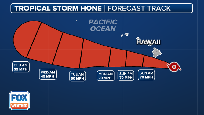
The National Hurricane Center says hurricane hunters found Hone’s peak wind speeds are now up to 65 mph with higher gusts as of Saturday evening, with the center of the storm less than 200 miles away from Hilo.
On the forecast track, the center of circulation will remain south of the Hawaiian Islands during the next several days.
Forecast cone for Hone
(FOX Weather)
The tropical storm is expected to remain far enough south of the islands to prevent a direct landfall, but the storm will pass close enough to bring heavy rain and strong winds to many of the islands, especially on the mountain downslope areas.
"The many different ecosystems of the Big Island will have different affects," said FOX Weather Correspondent Robert Ray. "The south shores will have the heaviest wind and lots of precipitation. In Hilo, in some areas, maybe a foot or so of rain… The problem with that kind of rain is that this is a very tough terrain. It's mountainous, it’s hilly, there are people that live on the hillsides, and there could be major problems with flash flooding and mudslides and rockslides."
What are the expected wind impacts for Hone?
Strong and gusty winds are expected to impact the Big Island, with widespread gusts of 50 mph, according to the National Weather Service. The strongest gusts are expected along the South Point/Ka Lae area, and along the downslopes of the island’s vast mountains.

(FOX Weather)
Pressure gradients will tighten across the rest of the island chain as Hone continues its trek west through the weekend, with winds of 25-35 mph gusting as high as 50 mph likely across Kauai, Lanai, Maui, Molokai, Niihau and Oahu into Monday morning and as a result, a Wind Advisory is now in effect for those islands.
What are the expected rain impacts with Hone?
Even without a direct landfall, Hone will bring widespread heavy rainfall into Hawaii, where the moist, tropically-infused winds will slam into the windward side of the mountains along the islands, squeezing out torrential downpours.

Rain forecast from Hone on Hawaii.
(FOX Weather)
As much as 5-8 inches of rain is forecast along the windward and southeast facing slopes of the Big Island, with isolated areas receiving even higher amounts. Meanwhile, embedded showers and thunderstorms from Hone’s rainbands will bring quick accumulations and potential for localized flash flooding. A Flood Watch remains in effect for the Big Island starting Saturday afternoon.
For the rest of the islands, about 2-4 inches of rain is expected on the windward sides with showers and thunderstorms spreading east to west along the chain Sunday into early next week.

How Hawaii's dramatic topography leads to wild variations in rainfall over short distances
Rainfall totals are expected to vary greatly between the windward and leewards sides of the Hawaiian Islands due to Tropical Storm Hone. FOX Weather Meteorologist Steve Bender explains how Hawaii's mountains have a super-sized impact on where and how much rain falls.
In addition, life-threatening surf and rip currents are expected along the Hawaiian beaches through the weekend.
The National Park Service announced Saturday it closed the coastal and Mauna Loa summit backcountry to hiking and camping at Hawaii's Volcanoes National Park due to the inclement weather.
The county's emergency management opened four shelters ahead of the storm, which are expected to stay open through the duration of the tropical weather alerts.
Dry, gusty winds ahead of Hone ramp up fire threat
While the windward sides of the islands await the heavy rains from Hone, the rain-shadowed leeward sides face dangerous wildfire conditions Saturday. Drier air is pushing into Hawaii ahead of Hone’s arrival, and the combination of a dry air mass and increasing downslope winds ahead of Hone has prompted Fire Weather Warnings for the leeward of the islands through Saturday afternoon.
While this atmospheric set up is nowhere near as dire as what triggered the deadly wildfires in Maui in 2023 as a much stronger Hurricane Dora passed to the south, fire weather conditions are present through the day.
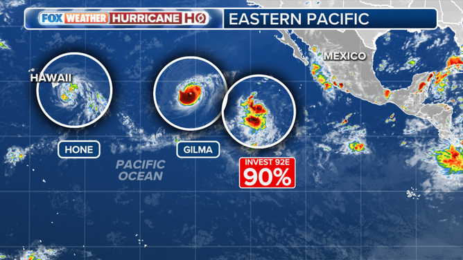
Two other tropical systems lurk behind Hone
It's not just one, but three tropical systems in the eastern and central Pacific Ocean under watch from the National Hurricane Center.
The strongest of the systems is Hurricane Gilma, which is about 1,700 miles away from Hawaii. Similar to Hone, Gilma is moving westerly or west-northwest, in the general direction of Hawaii.
The Category 3 hurricane had plenty of warm water and sufficient moisture, which allowed the tropical cyclone to strengthen into a major hurricane as it continues to trek westward.
Active storms in the Pacific.
(FOX Weather)
Gilma is expected to remain a hurricane through much of the upcoming weekend, but the National Hurricane Center forecasts weakening during the next several days with the storm dropping below tropical storm status well before any approach to Hawaii. And due to its slow forward speed of about 6 mph, the storm system’s closest approach to Hawaii would likely not occur until around the Labor Day weekend.
But while Gilma may no longer be organized by the time it would near Hawaii, forecasters are watching for potential of a renewed round of heavy rains from the storm's remnants.
Behind Gilma is a third tropical disturbance designated as Invest 92E. Some strengthening is forecast, likely becoming a tropical depression by early next week, the NHC said. If it reaches tropical storm strength, it will be named Hector.
The hurricane season in both the Central and Eastern Pacific runs through Nov. 30.