What’s next in the tropics after Beryl?
According to climatology, July is typically the fourth busiest month of the season, running behind September, August and October. The next tropical storm will earn the name of Debby. The 2024 hurricane season will end on November 30.

New updated hurricane forecast by CSU experts is even more aggressive in calling for 'hyperactive' year
Experts at Colorado State University have upped their forecast for the number of hurricanes and major hurricanes in the Atlantic basin just a day after record-breaking Hurricane Beryl made landfall in Texas.
After a busy couple of weeks with the formations of Alberto, Beryl and Chris, the Atlantic basin appears destined for a break in tropical activity as Saharan dust becomes dominant.
The 2024 hurricane season started off on a quiet note, but beginning around June 19 and lasting for about four weeks, cyclones impacted countries from the Caribbean to Mexico and even the United States.
Two of the formations - Alberto and Chris - were caused by a weather phenomenon called the Central American Gyre, or CAG for short, while Beryl formed from a low-latitude disturbance in the central Atlantic.
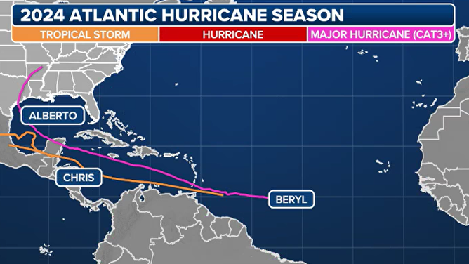
Hurricane season 2024 summary
(FOX Weather)
Without a CAG in the western part of the basin and disturbances being affected by dry air and dust in other regions, most of the Gulf of Mexico, Caribbean and Atlantic appear to be shut down for tropical cyclone formation for the time being.
It isn’t unusual for there to be a lack of tropical activity in July as hostile conditions are usually more prevalent than not in the basin. Although the tropics are not 100% dormant now. A new tropical disturbance is being monitored off the Southeast coast, though the NHC only gives it a 10% chance of development.

(FOX Weather)
According to climatology, July is typically the fourth-busiest month of the season, running behind September, August and October.
WHY THE WAFFLE HOUSE INDEX IS IMPORTANT WHEN EVALUATING SEVERE WEATHER EVENTS
Significant plumes of dust and dry air are common during the first months of the hurricane season and usually persist through mid-August.
NOAA estimates that more than 180 million tons of dust leave the African continent annually, significantly reducing moisture in the air.
If levels of SAL maintain their steadiness after about August 20, there will be significant ramifications for both the number of cyclones and their overall strength in the Atlantic basin.
Saharan dust was not an issue during the formation of any of this year’s named storms but did play a role in the demise of Invest 96L, which was being monitored several hundred miles to the east of Beryl in the Atlantic.
Water temperatures across large parts of the basin continue to clock in at above-normal values; however, they have decreased from record highs.
Ocean temperatures of around 80 degrees and above are considered sufficient to support tropical cyclone formation, but other influences, such as moisture and upper-level winds, must also be conducive.
![This map shows where tropical cyclone activity tends to occur in July.]() Image 1 of 2
Image 1 of 2This map shows where tropical cyclone activity tends to occur in July. ( )
![This map shows where tropical cyclone activity tends to occur in August.]() Image 2 of 2
Image 2 of 2This map shows where tropical cyclone activity tends to occur in August. ( )


MILLIONS STILL WITHOUT POWER IN SWELTERING HEAT AS TEXAS BEGIN CLEANING UP IN HURRICANE BERYL'S WAKE
During an average year, the fourth-named storm usually doesn’t form until around August 15.
It is also during the last month of meteorological summer that forecasters will pay closer scrutiny to waves coming off Africa as the entire basin becomes climatologically favorable for formation.
The hurricane forecasters at Colorado State University maintain that 2024 could be a busy year in the Atlantic for tropical storms and hurricanes.
CSU released its updated outlook on Tuesday, which calls for an additional 22 named storms to form, with 11 becoming hurricanes.
"It's really a matter of like what we have seen with Hurricane Beryl up until now. This is pretty early in the season, and having this kind of unprecedented storm come around is what made us increase our numbers," said Angelie Nieves Jiménez, a hurricane researcher at CSU.
The season runs through November 30, but the bulk of the activity tends to favor August, September and October.
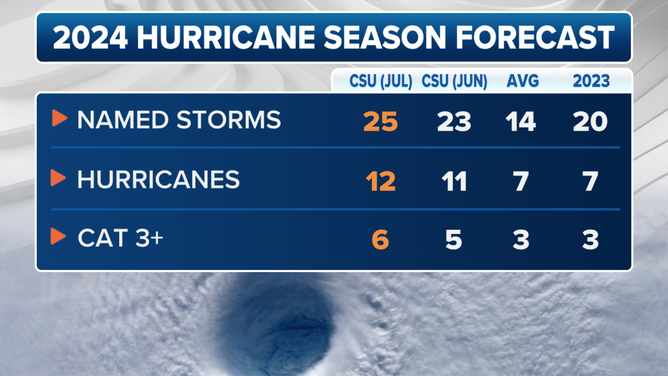
2024 updated Colorado State University hurricane season forecast.
(FOX Weather)